|
|
Mountain/Rock |
|---|---|
|
|
42.15470°N / 13.37110°E |
|
|
Hiking |
|
|
Spring, Summer, Fall, Winter |
|
|
7726 ft / 2355 m |
|
|
Overview
Even if Monte Velino is more attractive and the highest mountain of the Group Velino-Sirente (Appennino Centrale, Italy), the hikers have more opportunities to enjoy the beautiful and interesting landscape of the Group. One of the possible targets is Monte di Sévice (2355 meters), connected to the Monte Velino by a short but steep ridge to SE direction. Together with Monte Cafornia (2423 meters), Monte di Sévice is one of the three summits of the Velino massif. The main routes to Monte di Sévice are from the W-SW side and it can be climbed also joining the ascent to Monte Velino (it depends on our legs).
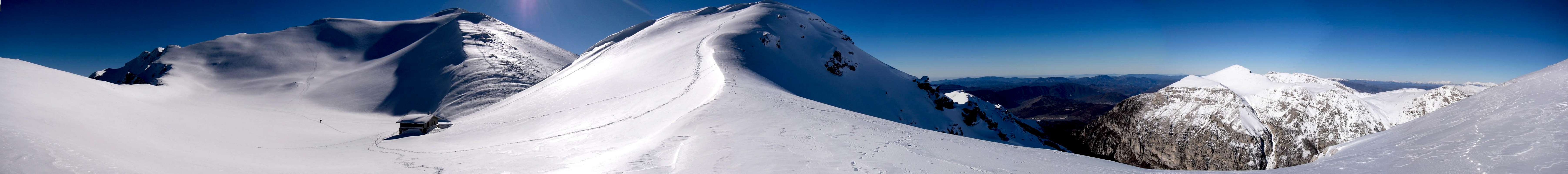
The summit is placed in a interesting environment with the peculiar U-shaped valley of Val di Teve. In Appennino Centrale, this is rare case of glacial valley. It is characterised also by a very long rocky (calcareous) wall running on its S side, called Muro Lungo (2124 meters), known within the climbers community as a hard climbing area due to the really bad rock quality rather than its climbing difficulties. This mountain belongs to the Natural Reserve of Monte Velino, placed within the wider Regional Natural Park of Sirente-Velino. The access to the Val di Teve, possible from the village of Cartore, is forbidden from February till May cause of the presence of the eagles. 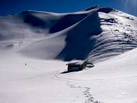 The summit The summit Muro Lungo-Val di Teve Muro Lungo-Val di TeveGetting There The main starting points of the routes are from the village of Rosciolo dei Marsi (899 m) and from the few houses of Cartore (944 m). FROM ROME By car:The fastest way is the Highway A24-Roma/L’Aquila. Starting at Rosciolo dei Marsi: Leave the Highway A24-Roma/L’Aquila (after about 60 km) and turn right following the Highway A25 towards Pescara. Exit at Magliano dei Marsi (10 km). Continuing for few kilometres, follow the indication towards Rosciolo dei Marsi and then the indications of the Natural Reserve of Monte Velino. Just before a beautiful Romanic Church (Santa Maria in Valle Porclaneta, 1022 m), take a not asphalted road connecting Rosciolo to Cartore. Depending on the condition of the road, you can to leave, or not, the car in this place.  Cartore Cartore Starting at Cartore: Take the Highway A24-Roma/L’Aquila till the exit Valle del Salto. Turn left and after about 700 meters, leave the main road (indication: Maneggio) and take a not asphalted road. Continue for few kilometres (about 5 km) till the houses of Cartore. Parking is possible close a pic-nic area. By bus transportation From Rome is available a bus transportation (CO.TRA.L) connecting downtown with many villages of Lazio Region. For starting from Cartore, take the bus till the bus-stop "Valle del Salto-A24". For planning the trip see the CO.TRA.L web-site. Route overview The Club Alpino Italiano (CAI) hardly worked in the past to improve the access to the summits of the Velino massif. Some routes are well marked and easily recognizable (mainly in summer), in other cases you must find the easiest (intuitive) and most logical ways along the slopes of the massif. All the routes are suggested for hikers, but depending on the season, they can be more or less tiring. The base of the ascents are in some cases characterised by tangled beechwoods (Fagus sylvatica), while the upper part you find steep slopes, alternatively grassy or stony.
 Route map - RED= W-ridge; BLUE= From Passo le Forche; ORANGE= Vallone di Sévice Route map - RED= W-ridge; BLUE= From Passo le Forche; ORANGE= Vallone di Sévice From Cartore (944 m) by the W ridge. The route is only partly marked in the upper part. It runs along the W ridge till the Capanna di Sévice (Sévice hut) located at 2119 meters. From the Capanna di Sévice reach the summit by the steep NW side. The ascent request about 4:00-4:30 hours. More time is needed in winter depending by the snow condition. For the descent following the same trail to the Capanna di Sévice. Traverse the S-side of Monte Rozza and descending the SW slopes you gain the road connecting with Cartore. This route is less frequented than others (about 1400 meters of difference from starting point to the summit) but the view on the wonderful Val di Teve and of the Monti della Duchessa from the W ridge is more gratifying with respect to the routes on the SW side.
From Rosciolo-Passo Le Forche (1221 m). This is the normal route partly marked with yellow-red indication. About 3:30-4:00 hours for about 1130 meters. Descent by the same route or along the W ridge.
By the Vallone di Sévice (1090 m) on the SW side. This route goes through the Vallone di Sévice separating the SW-side of Monte di Sévice and Monte Rozza (W ridge). Tiring and long route partly marked with yellow-red indication. About 4:00 hour for about 1260 meters. Descent by the same route.
When to climb The mountain can be climbed all over the year, but the relevant effort needed suggests to tackle it in fall or in summer (at early morning).
 Vallone di Sévice Vallone di Sévice W-ridge W-ridge In winter the climb is pleasant, not requiring in general the use of crampons, excepted in the last part of the ridge connecting the Capanna di Sévice with the summit. I was on the Monte di Sévice only in winter. In that occasion, the high temperatures and the risk of avalanches on the SW side forced me to ascent the mountain starting in the early morning in the dark.
In case of need and emergency you can cal the phone number 800.25.82.39, operating in all the Abruzzo region. Mountain meteoAn international reference can be the AccuWeather, web site.In addition, a useful site could be the Aeronautica Militare-Servizio Meteorologico web site (In Italian). Refuges Capanna di Sévice Capanna di Sévice The ascent is supported by the rifuge Capanna di Sèvice (2119 meters), 10 beds. Phone: +39-0347-6873118. The key of the refuge is at the tobacco shop in Magliano dei Marsi (contact Danilo Santoponte +39-0863-51133) or to the Bar Martino in Magliano dei Marsi (+39-0863-517889). In winter one room is always opened (12 beds)
Books and MapsTwo books in Italian including not only routes towards the Monte Sevice but even in Abruzzo and in the Regional Park:-Stefano Ardito "A piedi in Abruzzo", 2003 (in Italian). Guide ITER (Subiaco, Roma) – ISBN 88-8177-029-6; -Narciso Galiè, Gabriele Secchioni “Parco Regionale Sirenette-Velino-Le più belle escursioni”, 1999 (in Italian). Edited by Parco Regionale Sirente-Velino and Club Alpino Italiano-Società Editrice Ricerche – ISBN 88-86610-12-2 The main maps are: -CAI (Delegazione Abruzzese) – “I sentieri della provincia de L’Aquila. Gruppo Velino-Sirente” CdC L’Aquila (1:25000); -IGMI Fogli n° 146 III NE (Monte Sirente), 146 III SE (Pescina), 146 IV SE (Tione degli Abruzzi), 145 IV SE (Magliano dei Marsi). |