|
|
Mountain/Rock |
|---|---|
|
|
48.87917°N / 114.09611°W |
|
|
Flathead |
|
|
Hiking, Scrambling |
|
|
Summer, Fall |
|
|
9891 ft / 3015 m |
|
|
Overview of Rainbow Peak
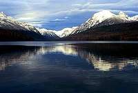
Rising over a vertical mile from the surface of Bowman lake in the Northfork district of Glacier National Park, Rainbow Peak is a dramatic mountain featured in many a panoramic photo. Thousands of leisurely auto tourists make their way along the dusty Northfork road to one of its popular terminus' - Bowman Lake - from where Rainbow Peak rises 5500 some odd feet above the surface of the lake. As one stands on the lake shore they are presented with a view of Numa ridge to the Northwest and Quartz Ridge to the Southeast. Dominating the Southeast of this panorama is the formidable Rainbow Peak. | |||
Parentage of Rainbow Peak
| |||
Getting to Rainbow Peak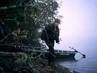 Approach via watercraft. Approach via watercraft.Climbers will have no difficulty getting to within six miles of the summit by car as a road from the National Park Boundary at Polebridge, MT winds its way to the foot of Bowman Lake. From here access to the base of the peak is via two methods. Canoes, kayaks and low horsepower motorized watercraft are allowed on the waters of Bowman Lake. Take note that Glacier National Park has a strict policy that all boaters must wear life jackets. Climbers can follow the Southeast shoreline of of the lake to the semi-prominent point in the lake where an audibly noticeable creek empties. It is here that climbers can stash their boats and make their way by land. The second obvious approach is via land and significantly more difficult than a water approach. A trail from the foot of the lake extends to the head of the lake where Bowman Lake backcountry campground is located. From here it is possible to bushwhack the approximately 1.5 miles to the same creek outlet described in the water approach. | |||
Climbing Rainbow Peak
| |||
Climbing Informational Resources Midpoint, looking West. Midpoint, looking West.Another excellent resource for climbing information in and around Glacier National Park are the friendly folks at Rocky Mountain Outfitters in Kalispell, MT. Finally, if you get the chance to get into a conversation with NPS backcountry rangers, trail crews, fire fighters or anyone else who spends time in the backcountry a wealth of information can be gathered. In Polebridge, look for these folks at the Northern Light Saloon and in West Glacier check out Frida's West Glacier Bar. | |||
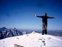
Climbing Considerations for Rainbow Peak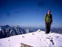 Stoic above the Bowman drainage Stoic above the Bowman drainageAnother consideration to take into account is the overall instability of rock in the park. Because of this there is a special grading systems unique to the Park developed by both J. Gordon Edwards and the Glacier Mountaineering Society. Reading documentation on this grading system should be mandatory for anyone doing off-trail travel in the high country. Please educate yourself on the information put together by Fred and Moni Spicker: Glacier National Park Rock & Grading Systems. | |||
Camping and Lodging Near Rainbow Peak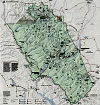 GNP Map GNP MapFor backcountry camping options visit with a National Park Service ranger at either the Northfork entrance (NW of Polebridge) or the backcountry permit office located in West Glacier. A backcountry camp accessible via the lake or trail is located at the NW corner of Bowman Lake. For undesignated camping somewhere along your route to the summit a special permit must be aquired. Inquire at the above locations. Car camping is available at the Bowman Lake campground located at the foot of the lake. In the unlikely event this campground is full or closed there are also informal camping options along the North Fork of the Flathead River locatd on USFS land outside the village of Polebridge. Polebridge proper also has lodging opportunities. There is an inexpensive hostel located there as well as good eats at the Polebridge Mercantile and Northern Lights Saloon. | |||
Bear Habitat near Rainbow Peak[img:425263:alignleft:small:GNP Map]Refer to the main Glacier National Park page for red tape and restriction information. However special attention should be paid to the bear habitat that Rainbow Peak and nearby campgrounds are located in. Grizzly and black bear population is high in the Bowman Lake area and proper care should be taken in the consumption and storage of food. Follow official Glacier National Park strategies for the safety of yourself and the wildlife. | |||
External Links |