
-
 9888 Hits
-
 78.27% Score
-
 9 Votes
|
|
Mountain/Rock |
|---|---|
|
|
34.55920°N / 117.7216°W |
|
|
Los Angeles |
|
|
Hiking |
|
|
3581 ft / 1091 m |
|
|
Overview

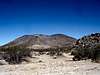
Black Butte is a old familiar friend for those who have been in the San Gabriel Mountain high country at sunset and watched the light change on the Mojave Desert. In the immediate foreground there is little black as coal butte called Black Butte breaking up the tan sands of the Southwestern Mojave Desert. It is a well known natural landmark in the open desert country. It is a quick short jaunt that could be combined with any multitude of buttes and little peaks that dot this landscape. A more traditional peak to combine would Saddleback Butte. Black Butte has a prominence value of 531 feet, ranking 31 on the San Antonio Cell.
Getting There
Take whatever route you like to get yourself on the 395 Highway and reach the desert town of Adelanto. From Adelanto take the turnoff from the the 395 to Rancho Road towards El Mirage Dry Lake. There are signs for this turnoff for El Mirage. Head east then make a right turn after a couple miles at the junction. Once again follow the signs. Reach another junction and turn left resuming your progress west now on El Mirage Road. Conitnue pass El Mirage and hit another junction. Turn left(south) on 240th Street towards Palmdale. After 1.5 miles turn right at the signs for Palmdale. Black Butte is now in front of you to the southwest. Conitnue about a quarter miles and turn left (south) onto 235th Street. It is a well oiled dirtroad. Take this road for about 2 miles as it passes the east slope of Black Butte. Turn route onto one of the many little dirt roads that lead up to the southeast ridge. Park and head up the ridge.Route
 |
 |
 |
From the parking area hike up the firebreak like scar along the southeastern ridge. First you reach a false summit and then connect over to the open summit.
Roundtrip is about 1.5 miles with 600 feet of gain.
External Links
Weather UndergroundFor road and highway information in San Bernardino County.