
|
|
Mountain/Rock |
|---|---|
|
|
40.76360°N / 107.05757°W |
|
|
Hiking, Mountaineering, Scrambling, Skiing |
|
|
Summer |
|
|
10879 ft / 3316 m |
|
|
Overview-Colorado's Forgotten Mountain Range
Meaden Peak East is the highest peak in the Elkhead Mountains. It rises to the west of Steamboat Lake, and is much photographed from that direction, usually in conjunction with Sand Mountain. Remarkably, the first four highest peaks in the Elkhead Mountains are all within 40 feet in elevation, so Meaden Peak East doesn’t stand that much taller than its neighbors. Meaden Peak East is just barely below timberline, and receives heavy winter snows. In a normal year, the snowbanks on the mountain stay until sometime August, and sometimes year-round.Several aspects of the Elkheads make this a rather unique mountain range in Colorado. It is certainly possible that the Elkhead Mountains are the least known of the major mountain ranges in Colorado. This is partially because the range is a long way from any metropolitan area, and partially because the Elkheads are fairly low by Colorado standards, as there are no peaks reaching 11,000 feet. There are also few lakes, so the range isn’t visited by fishermen. Despite their low altitude, the Elkheads receive much snow, and snow lasts into July on the higher peaks. Most of the peaks in the Elkheads see very few ascents, but Hahns Peak, the eastern-most peak in the range is a popular climb for residents of Steamboat Springs. The Bears Ears see quite a few ascents by Elkhead standards, because of their prominent shape and visibility from the Yampa River Valley. Black Mountain is also climbed fairly often because it is the highest point in Moffat County, and the popularity is on the increase with more county highpointing interest. Sand Mountain must be a fairly popular (by Elkhead standards) climb as well, as there is a trail to the top, and as it is the first and only mountain in the range where I have ever met anyone. This was on Labor Day weekend, 2005, when we saw 3 other hikers. Most of the rest of the peaks see few ascents, and one ranger has told me some of the peaks only have a few names in the registers since 1980. So, there are few hikers around, but hunting is another story. The Elkheads are very popular for hunting in the fall and contain large populations of deer, elk, bear, etc.
One thing unique about the range is that hiker use is overall actually decreasing, rather than increasing as it is in most places in Colorado. The summit registers (which the Forest Service keeps record of) on most peaks indicate that they have had more ascents in the 1960’s and 1970’s than they do now. Even before that, there were many summit logs from the 1930’s and 1940’s from sheepherders.
The Elkhead Mountains are made of old volcanic rocks 17-25 million years old. One thing unusual is that the Elkhead Mountains run west to east as opposed to north and south as most of the ranges run in North America. It is impossible to describe the general forms of the peaks because they are all so different, but most of the peaks are isolated rises from a huge plateau which forms the bulk of the Elkheads.
Elkhead Mountains-10,000+ Foot Peaks with 300+ feet of Prominence
 Meaden Peak East as viewed from the south on July 26 2008.
Will the Real Meaden Peak Please Step Foreward?
Even though Meaden Peak East is the highest mountain in the Elkhead Mountains, there is some confusion about the name of the mountain or even a debate as to if there is a real name at all!According to Kramarsic’s book on the history of the area, the name Meaden Peak originally identified the peak to the west at 10,561 feet that overlooks California Park. In 1932 the wrong name was applied on the map to this, the highest peak in the Elkhead Mountains. Because of this, the 7.5 minute map labels this peak as Meaden Peak and since the mistake was made almost 80 years ago, most locals refer to the peak as Meaden Peak (especially when viewing it from the east), East Meaden Peak, or Meaden Peak East. The name McFaddin Peak has also been proposed for this peak.
The website listsofjohn adds yet another name of "North Sand Mountain", but since the mountain is already known by several other names, adding yet another name will only add to the confusion.
USGS Link
7.5 Minute Map designation of Meaden Peak:
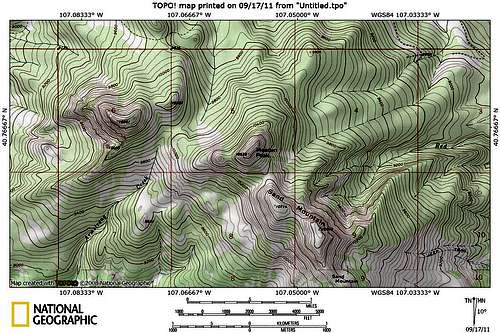
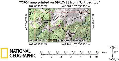
1:100,000 Map designation of Meaden Peak (the red dot is the Meaden Peak on the 7.5 Minute Map):
Navigational Warning
Warning:The topo maps currently available don’t show the roads or trails around this mountain accurately. The closest one that bears resemblance to reality is the Forest Service Map-Routt National Forest, but it is of a small scale. The USGS maps don’t show many of the roads in the areas, but seem to show roads and trails that don’t exist; at least not any more.
Update:
The USGS has (finally) updated the 7.5 minute maps. They were scheduled to be produced for Colorado last year, but I’m not sure when they will hit all the stores. Right now you can get/see/print/buy the new 7.5 minute maps on My Topo.
On the new 7.5 minute maps, Meaden Peak is still Peak 10879.
The good news is that all the roads and trails are FINALLY accurate for the Elkhead Mountains (and undoubtably other areas as well). After receiving the new maps, I am very pleased to see that the roads and trails are in the right places. I am also very pleased that the USGS has a new agreement with the US Forest Service and within the national forest service areas, the private land holdings are shaded (but only in USFS areas, land ownership is not shown outside FS lands) on the 7.5 minute scale maps.
Overall, I am very pleased with the new 7.5 minute maps. They didn't do anything to alleviate any confusion on Meaden Peak though.
Getting There
Without directions, these trailheads aren’t exactly easy to find, so I took lots of notes and have done my best to explain them. On our first attempt, we failed to find the correct trailhead, so these directions should help, even if they sound slightly confusing! The maps of the area are not accurate!!VIA STEAMBOAT SPRINGS
Option #1, East Loop:
From Steamboat Springs, drive to the north end of town and to where County Road 129 leaves Highway 40. A sign marks "Clark" and "Hahns Peak". This is the same road heading to the airport. Drive north on CR 129 for approximately 26 miles. Pass Steamboat Lake and turn left on County Road 62. Drive County Road 62 west and south for about 3.5 miles to FR 42 on the right. Turn right on FR 42 and drive for 0.6 miles to the forest service gate. This gate is locked until July 1st each year. Drive County Road 42 for 1.5 miles to where FR 480 (east loop) takes off to the left. The road here is bumpy, but still passable to 2wd’s if you go slowly. Turn left on to FR 480 which is a very rough 4wd road. Before driving this road, make sure you have a competent 4wd. We witnessed a grouse hunter damage his Dodge Durango on this road, so use caution. Follow the rough FR 480 for 3.3 miles to where the better road 480A turns left. Follow 480A for 0.5 miles to its end. This is the trailhead.
Another possible trailhead is road 480B (see the Routes Overview). From the junction of FR 480 and FR 480A as mentioned above, you can also turn right on 480 instead of left on 480A. If you do this, follow FR 480 for 0.8 miles to FR 480B. Turn left on FR 480B and follow this short road to its end.
 Sand Mountain (left) and Meaden Peak East (right) as viewed from the Southeast and on the road to the trailhead on July 26 2008.
Option #2, West Loop:
If you don’t have a 4wd, and if you want to minimize road walking, you may want to choose this option. From the Junction of County Road 42 and FR 480 (east loop), continue straight along County Road 42 and follow the bumpy road for another ~3.7 miles. The west loop of FR 480 takes off to the left. Park here if you have a 2wd, or follow FR 480 left for 0.4 miles to 480B (see above). To reach the trailhead at 480A, continue on FR 480 for another 0.8 miles to the junction of FR 480A. Turn right on 480A and follow it 0.5 miles to the trailhead.
VIA HAYDEN
From Walnut Street in Hayden, turn north on Walnut, a.k.a. County Road 76, and follow it north for 0.7 miles to County Road 80. Turn right on (gravel) County Road 80 and follow it for 27.3 miles to FR 42. Turn right on FR 42. The first 2.5 miles of FR 2.5 are pretty good, but it quickly turns into a 4wd road after that. The rough section last for 1.4 miles and ends at a saddle. Continue straight at the saddle (instead of heading left), and follow FR 42 for another 0.8 miles. At this point, FR 480-West Loop takes off to the right. See the above paragraph for directions to the trailhead from here.
Routes Overview
Meaden Peak East is a steep mountain, but not a rugged mountain so several routes are possible. The below outline a few possibilities, but there are other routes on the mountain. There aren’t any technical routes available, but the biggest obstacle might be steep scree on some routes. In addition to the below, you could find other routes, such as via the north spur from FR480.Via the East
Perhaps the easiest route up the mountain from the east is to follow Trail #1175 from the end of FR 480A before leaving the trail and scrambling to the pass between Sand Mountain and Meaden Peak East and then north to the top. This route is short and steep, gaining over 1500 feet in a short amount of time. There is a more direct route, but it appears to have more loose scree and is not recommended.
Via the South and Sand Mountain
Meaden Peak East can be combined with Sand Mountain for a nice loop hike. From the summit of Sand Mountain, I followed the ridge straight over the top of Sand Mountain’s north summit and down to the Meaden Peak East/Sand Mountain saddle, but it’s probably easier to follow the Sand Mountain trail back down towards the trailhead until you can skirt around most of the extensive talus fields. Even with climbing both peaks, this is just a vigorous half day climb if you are in reasonable shape.
Via the West Ridge
An alternate route is via FR 480B (see “Getting There”). From the end of that road, a trail climbs south to a saddle between the two Meaden Peaks and then drops to the meadows to the south. Instead of dropping down to the meadows, it seems like a relatively straight forward and steep scramble along the west ridge to the summit. Joseph Kramarsic has climbed this route to the summit and labels the route as class 2.
 Meaden Peak East as seen from the south and from the north ridge of Sand Mountain.
Red Tape
No permits are required.When to Climb
July through early September could be considered the normal season to climb the mountain. The access road doesn’t open until July 1, but the roads could certainly be walked, snowshoed, or skied before then. The Elkheads are a very popular hunting destination in September and October (until snow closes the road), so use extreme caution at this time of year. In winter, this mountain isn’t that far from the road closure, so it could be climbed in two days, or possibly in one very long day in winter.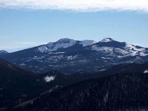 Sand Mountain and East Meaden Peak as viewed from Nipple Peak in February 2006.
Camping
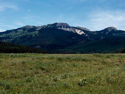
There are many informal campsites along the road to the trailheads after you reach the forest boundary. Also in the area are the campgrounds at Pearl Lake and Steamboat Lake State Park. These are crowded on summer weekends, and reservations are recommended. Hahns Peak Lake is a Forest Service Campground in the area. All the campgrounds are fee-use areas.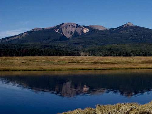 Sand Mountain (center) as viewed from the east, rises above Steamboat Lake. September 3, 2005. East Meaden Peak is the cone shaped peak on the right.
Mountain Conditions
CLICK HERE FOR THE MEADEN PEAK EAST AREA WEATHER FORECASTBelow is the National Weather Service Climate Summary of Steamboat Springs. The data is from 1908-2005. This is the closest long term weather station, but be aware that higher elevations will be much wetter and colder. Steamboat Springs is at 6695 feet elevation, so expect the temperatures on Meaden Peak to be 10-20 degrees colder than in Steamboat (except for cold winter nights).
| MONTH | AVE HIGH | AVE LOW | REC HIGH | REC LOW | AVE PREC (in) |
| JAN | 29 | 1 | 57 | -54 | 2.47 |
| FEB | 34 | 4 | 59 | -48 | 2.24 |
| MAR | 42 | 13 | 70 | -34 | 2.11 |
| APR | 54 | 24 | 79 | -15 | 2.28 |
| MAY | 65 | 31 | 88 | 8 | 2.08 |
| JUN | 75 | 36 | 96 | 19 | 1.49 |
| JUL | 82 | 41 | 97 | 25 | 1.54 |
| AUG | 80 | 40 | 98 | 20 | 1.60 |
| SEP | 72 | 33 | 93 | 6 | 1.81 |
| OCT | 60 | 24 | 89 | -16 | 1.89 |
| NOV | 43 | 14 | 72 | -28 | 1.97 |
| DEC | 31 | 3 | 64 | -44 | 2.38 |