
|
|
Mountain/Rock |
|---|---|
|
|
36.31838°N / 50.98493°E |
|
|
Mountaineering |
|
|
Summer |
|
|
13222 ft / 4030 m |
|
|
Overview
Click for Introduction to the Central Alborz Mountains.Click to see the Map of the Takhte Soleyman Massif.
Note about name and elevation: Khers Char is also known as “Lashgarak Sarband”. The Iranian 1:50 000 Map shows an elevation of 4017 m for this peak. My GPS showed 4030 m so I decided to use that figure.
Khers Char Peak:
Elevation: 4030 m, 13222 ft
Coordinates: 36.31838 North, 50.98493 East
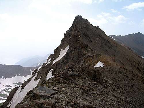 Northwest Face
 SE Face
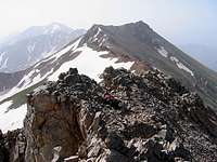
 Summit from SE
Khers Char is a small but very pointy peak that rises on the crest of the ridgeline that forms the southeastern arm of the Takhte Soleyman Massif. Although lower than its neighbors, the rocky triangular shape of Khers Char gives it prominence among the peaks of the area.
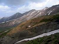
To the northwest, Khers Char is connected to the 4184 m Lashgarak the Small Peak and to the southeast, it is connected to the 4065 m Alaneh Sar Peak (via Peak 3990 m, see below). The northeastern slopes of Khers Char are walls/steep rocky slopes that drop 200 vertical meters into a snow-filled alpine bowl. This bowl drains into a branch of the Chalus River. The southeastern slopes of Khers Char go down into a branch of the Shah Rood (Taleghan) Valley.
Khers Char is a long way from any trailhead. Reaching its summit requires a multi-day hiking program. It is usually climbed by those who do a ridge-top traverse of the southeastern arm of the Takhte Soleyman Massif: from Lashgarak the Great Peak to Zarrin Kooh Peak. Reaching the summit of Khers Char or even bypassing it requires route finding and rock climbing skills but in my opinion is not hard enough to be classified as a technical climb.
 Southwest Slopes Southwest Slopes | 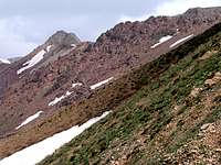 Southwest Slopes Southwest Slopes |  Summit Block from NW Summit Block from NW |  NW Slopes NW Slopes |
views from the summit of Khers Char:
 Alaneh Sar & Zarrin Kooh Alaneh Sar & Zarrin Kooh |  Bowl Bowl | 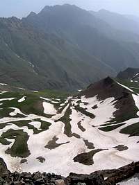 Abidar Abidar |
 KoliKosh & Taleghan Valley KoliKosh & Taleghan Valley | 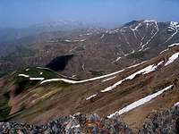 Meeshchalak & Shah Alborz Meeshchalak & Shah Alborz |  Lashgarak & Alam Kooh Lashgarak & Alam Kooh |
Peak 3990 m:
Elevation 3990 m, 13091 ft
Coordinate: 36.31483 North, 50.9953 East
 Peak 3990 m
Peak 3990 m sits on the ridgeline between Khers Char and Alaneh Sar Peaks. If you approach it from the northwest, you will see it as nothing more than a small ridge-top high point. From the southeast, however, Peak 3990 m appears as a jagged peak made of orange/reddish rock. Its northeastern slopes go down into a large alpine bowl that houses a small lake.
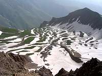 Bowl Bowl |  Bowl Bowl | 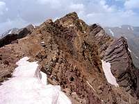 Summit Block Summit Block |  Very Top Very Top |
Route Information:
The starting point for this route is the summit of Lashgarak the Small Peak. Click here to see the page for Lashgarak the Small.
Distance from Lashgarak the Small to Khers Char: 1.35 Km
Distance from Lashgarak the Small to Peak 3990 m: 2.10 Km
From the summit of Lashgarak the Small (4184 m), hike down the southeastern slopes to reach the 3975 m saddle with Khers Char. These slopes are at times rocky and require route finding skills (see the “Southeastern Slopes” pictures on the Lashgarak the Small Page). You will then climb up the rocky northwestern slopes of Khers Char (see above pictures) to reach the summit of Khers Char. This will require extensive hand and foot rock climbing.
From the summit of Khers Char, do some hand and foot descending to go down its slopes until you reach an easy ridge-top that can be hiked. Continue southeast and hike to the top of Peak 3990 m. To continue to Alaneh Sar Peak, you must do some hand and foot descending again to get down to the saddle to the southeast of Peak 3990 m.