
|
|
Mountain/Rock |
|---|---|
|
|
40.69112°N / 110.5024°W |
|
|
Duchesne |
|
|
Hiking |
|
|
Summer |
|
|
12260 ft / 3737 m |
|
|
Overview
 Bluebell Peak from the S Bluebell Peak from the S Bluebell Peak from the NNE Bluebell Peak from the NNEAt 12260 feet, Bluebell Lake Peak with prominence of 440 feet ranks 84th on Scott's list of Utah 12,000+ Foot Peaks with 200+ Feet Prominence. Bluebell Lake Peak is one of five peaks over 12000 feet which line the ridge which forms the west boundary of Garfield Basin. From south to north/ smallest to largest, it is peak number two. Swasey Knob lies to the south and Stone Benchmark, South Porcupine Mountain, and Porcupine Mountain lie to the north. |
Kings Peak (13528), Utah's highpoint, lies 9 miles to the northeast. Mount Emmons (13440), Utah's 4th highest peak lies 10.5 miles to the east. There are good views of the entire Kings-Emmons ridge and in the late afternoon sun, the Timothy Peaks-Paul Benchmark ridge which lies in front about 1000 feet lower, will be streaked with bright yellow.
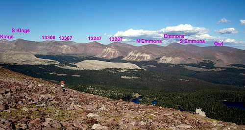 Kings-Emmons ridge
The highpoint of Bluebell Lake Peak sits at the south end of a .7x.4 mile flat plain of red rocks. The benchmark disk is located at N40 41.467 W110 30.144 in the middle of an easy to find 2x3 foot, flat, triangle shaped rock. Bluebell Lake lies 1400 feet below, .7 miles to the northeast.
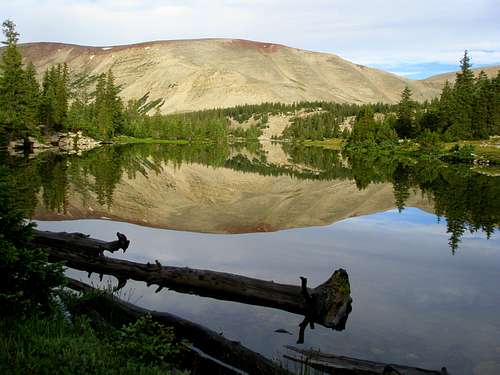
 Bluebell Lake
The summit is a 8.5 mile hike from the Center Park Trailhead to the south. Most people would not want to climb this peak by itself but would do it as part of a multiday trip to several summits. The best months to climb are July, August, and September.
Getting There
Access from the south is via the Center Park Trailhead.Red Tape
Group size is limited as per wilderness area rules. Many lakes have proximity restrictions. These restrictions change from time to time so check the sign board at the trailhead to see what restrictions are currently in place.Camping
There are 5 established campgrounds near the Center Park Trailhead as descriped in the trailhead page. There are numerous places to camp in Garfield Basin.Routes
From Center Park on the south Topo map
 Approaching Bluebell Lake Peak from the S
Start at the Center Park Trailhead and head north on the trail to Garfield Basin. After about 2.9 miles, leave the trail at N40 38.259 W110 27.603 and head for the 11193 benchmark to be found at N40 38.636 W110 29.439. Follow the ridge west and then northwest to the 11842 benchmark, the remains of which are found at N40 38.686 W110 29.439. Follow the ridge north to the 12007 bump and continue another 1.1 miles on flat terrain to Swasey Knob (12124). Continue north another 1.4 miles along the ridge until you come to the highpoint of Bluebell Lake Peak. The final 200 vertical feet are moderately steep and require some hand use but are not particularly difficult unless you are carrying a heavy pack. It is a total of 8.5 miles to the summit with 2726 feet of vertical gain. The elevation gain on the way back is 925 feet.
For the return you could either retrace your steps or descend northeast in the direction of Drift Lake and then head east and pick up the Garfield Basin trail just north of Spider Lake.
 Looking across Spider Lake at Bluebell Lake Peak
Garfied Basin Rim Loop
There are seven peaks above 12000 feet ringing Garfield Basin and they all can be done in one trip. See Garfield Basin Rim Loop.