
-
 32885 Hits
-
 81.18% Score
-
 13 Votes
|
|
Mountain/Rock |
|---|---|
|
|
33.06393°N / 117.08809°W |
|
|
San Diego |
|
|
Hiking |
|
|
Spring, Summer, Fall, Winter |
|
|
1150 ft / 351 m |
|
|
Overview
Bernardo Mountain is the most prominent feature west of I-15 on the northern shore of Lake Hodges. It climbs to 1,150 feet above sea level and is located at latitude coordinates - N 33.063931 and longitude W -117.088088. As part of the San Dieguito River Park, the Bernardo Mountain summit is reached from the Coast-to-Crest Trail at either the parking lot trailhead east of I-15 at Via Rancho Parkway and Sunset or from the west at the staging area near the Lake Hodges boat ramp, off Lake Drive. With its panoramic views, Bernardo Mountain is open for hiking, biking and equestrian use and is a fairly easy 7.2 mile hike. With it's Class 1 climb to the summit, Bernardo Mountain is also listed on the San Diego County Sierra Club Chapter's County Peak List.Getting There
The following 7.2-mile round-trip hike to Bernardo Mountain starts at the end of Sunset Drive, south of Via Rancho Parkway and just east of Interstate 15. This is a relatively easy hiking route but semi-technical for mountain bikes.Trailhead Location(s): Sunset Drive Trailhead: North on I-15, exit Via Rancho Parkway, go east. Take a right at Sunset Drive (first light) and drive to trailhead parking lot at the cul de sac or park along the street.
Start off heading south, parallel to the freeway, initially on a wide, concrete walkway. Battle Mountain (with cross on top) appears ahead.

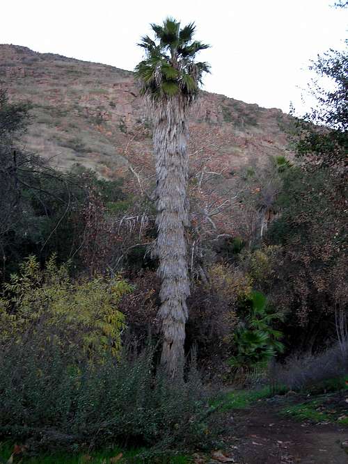
After about 0.4 mile, the pathway turns sharply right and passes under the Interstate 15 bridge that goes over the east arm of Lake Hodges. The reservoir is now almost completely dry, though heavy winter or spring rains this season or next could fill it again. After swinging north on the far side of the freeway, the path joins for a short time the crumbling pavement of the long-abandoned Highway 395, the former inland highway running north from San Diego into Riverside County. Soon, however, the pavement disappears and you're on a dirt trail heading southwest and slowly the trail follows the shoreline west. (Due to the recent fires and road construction, the shoreline trail is under maintenace. At this junction the trail detours to the west switchbacking over a small knob before heading south and merging with the shoreline trail heading west again). At 1.5 miles into the run, you cross Felicita Creek, a small perennial brook deeply shaded by oaks, sycamores, palms, and other water-loving vegetation.
You rise out of the creek and ascend moderately, wrapping around the broad south flank of Bernardo Mountain. At 1.7 miles in, a couple of minutes past the creek crossing, make a very sharp right turn on the path heading north. You ascend slowly, with the oaks and sycamores of Felicita Creek just below you on the right and Bernardo Mountain rising on the left. By about 2.5 miles, you've swung around to the north side of the mountain, where the chaparral vegetation thickens to jungle-like proportions and the ascent quickens. Stay left (uphill) at the next two trail intersections, always heading upward.
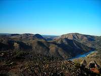
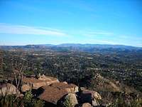
You continue either ascending or contouring in a long switchback pattern, passing a large water tank at 3.2 miles, and finally reaching the rocky summit at 3.6 miles. From this noble vantage point you can clearly visualize the patchwork of urban/suburban/wildland that inland North County has become. The white noise of traffic on Interstate 15 wafts upward to you -- but peering in certain other directions you see little apparent human impact on the landscape. Westward, down the valley below Lake Hodges, a slice of Pacific Ocean is visible on clear days. To the east; Woodson Mountain, Iron Mountain, and the Cuyamaca Peaks standout. A summit register (an old hang up mailbox) is tucked away among the boulders on the summit and a couple of cairns marking the north end of the summit.


Red Tape
No Permits required.Signs along the trail request that no cross-country travel be made.
During the weekend, mass quantities of bikers flock to this area and parking can be a nightmare. If the lot at the end of Sunset is full, parking is also available on the sides of the road and an overflow parking lot (dirt lot) is also available.
*Tip* Head out early and avoid the congestion.
MISC...
Bring plenty of fluids, a camera, and a nice snack for the summit.Topo of Bernardo Mountain.

External links
San Dieguito River ParkClimb Bernardo Mountain
Photos of My Bernardo Mountain Trip