
|
|
Mountain/Rock |
|---|---|
|
|
40.49617°N / 111.57663°W |
|
|
Utah, Wasatch |
|
|
Hiking |
|
|
Spring, Summer, Fall, Winter |
|
|
10349 ft / 3154 m |
|
|
Overview
Mill Canyon Peak, elevation 10349, is located on the border of Utah and Wasatch counties in Utah, 6.32 miles east of Box Elder Peak and 8.14 miles NNE of Mount Timpanogos. Its prominence is 1569 feet. There are several routes to the summit. All of them are technically easy (little more than class 1), but some require a significant vertical gain and some are a long way. There is however, at least one short route. There is no trail that goes to the actual summit, but it is a straightforward off-trail hike with minimal bushwhacking to the top.At the summit you will find a large cairn with a big stick protruding. There is supposed to be a benchmark at N40 29.770 W34.598, but I have not been able to locate it. One of the reference marks seemed to indicate a location directly under the cairn.
 Red Baldy and American Fork Twin Peaks behind summit cairn
From the summit, to the north one sees the south side of the Little Cottonwood Ridge. From left to right the most prominent peaks seen are White Baldy (11321), Red Baldy (11171), and American Fork Twin Peaks (11489). To the west lies 11101 foot Box Elder Peak.
 Box Elder Peak
To the SSW lies Mount Timpanogos (11749), probably the most scenic and most climbed major peak of the entire Wasatch range.
 Mount Timpanogos
When to Climb
 Mill Canyon Peak lies ahead in the clouds
Mill Canyon Peak can be climbed all year round. Fall is particularly nice because aspens predominate the landscape.
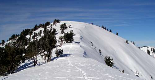 Looking back at the top on the way down
In the winter, you will probably not see any other person on your hike except near the trailheads.
Getting There (American Fork Canyon)
 Approaching American Fork Canyon on state route 92
Utah County, Utah is particularly blessed with dramatic views. Your drive to the trailheads mentioned below will be full of scenic vistas, unless you are hiking the Tibble Fork route in the dead of winter and you will be driving both ways in the dark.
 View N along state route 92 of the south side of the Little Cottonwood ridge
Tibble Fork Reservoir Trailhead 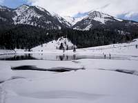 Tibble Fork Reservoir with Box Elder Peak behind Tibble Fork Reservoir with Box Elder Peak behindFrom Interstate 15 take Exit 294, Highland Alpine, Route 92 east towards American Fork Canyon. At the mouth of the Canyon you will come to the intersection with Route 146. From this intersection continue straight on Route 92 for 5 miles until the road splits (.6 miles past mile marker 12). Take the left fork, Route 144 for 2.1 miles to Tibble Fork Reservoir where you should park. If the lot is full, you can continue .3 miles to a much bigger parking lot, with an outhouse. In the winter, this is where the plowing ends. |
Mill Canyon Trailhead 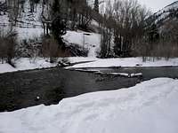 Looking back at the trailhead from across the creek Looking back at the trailhead from across the creekFrom Interstate 15 take Exit 294, Highland Alpine, Route 92 east towards American Fork Canyon. At the mouth of the Canyon you will come to the intersection with Route 146. From this intersection continue straight on Route 92 for 5 miles until the road splits (.6 miles past mile marker 12). Take the left fork, Route 144 for 2.4 miles to the end of the pavement. In the winter you will have to park here. Continue straight for .15 miles on a dirt road. There doesn't seem to be any official place to park. I just parked at the side of the road. The trail goes down hill a very short distance to meet American Fork Creek and continues on the other side. The creek is shallow but wide. There is no bridge and even in the middle of winter was not frozen over. Therefore, unless you don't mind getting your feet wet or come prepared with appropriate foot wear, I don't recommend starting here. |
Corral Trailhead
From Interstate 15 take Exit 294, Highland Alpine, Route 92 east towards American Fork Canyon. At the mouth of the Canyon you will come to the intersection with Route 146. From this intersection continue straight on Route 92 for 5 miles until the road splits (.6 miles past mile marker 12). Take the right fork, labeled Alpine Loop and continue along route 92 about 9.3 miles until you reach N40 27.209 W111 34.860 where a dirt road forks north. Follow the dirt road about 1.9 miles until it ends at a spot labeled "corral" on the USGS map.
This dirt road is not in the best shape. My husband drove it without any mishaps in our Subaru Legacy. I personally would be a little uneasy driving it in such a vehicle. On the forest service Mill Canyon map, this road is labeled with the number 180 and is deemed "Not suitable for passenger car". If you choose to walk the road it will add another 1.9 miles (one way) and another 720 feet of elevation gain to the hike.
Getting There (Alta)
Catherine Pass TrailheadHead up Little Cottonwood Canyon (state route 210) to Alta. Continue 1.9 miles on the dirt road that goes to the Catherine Pass and Albion Basin trailheads. At a large bend, you will find the Catherine Pass Trailhead on your right at N40 34.972 W111 37.109.
Routes Overview
The first three routes, Tibble Fork, Mill Canyon, and Corral, all converge about 2 miles before the summit. Almost at summit, looking back at Provo Canyon
Tibble Fork
This route has a detailed route page. Only an overview is presented here. It starts at the Tibble Fork Reservoir trailhead, climbs 3 miles via the Tibble Fork Trail (#041) to the southwest ridge of Mill Canyon Peak and then follows the ridge 4 miles to the summit, going over a series of small bumps. This is a very scenic route and you will be presented with grand views almost the whole way. When all the little bumps on the ridge are taken into account, the total round trip elevation gain is 5000'.
 About .6 miles after gaining the ridge, looking back at Mount Timpanogos
Mill Canyon  Topo map of Mill Canyon route Topo map of Mill Canyon route Mill Canyon route Mill Canyon route Box Elder Peak looms behind you as you follow Mill Canyon up to the ridge Box Elder Peak looms behind you as you follow Mill Canyon up to the ridgeAs far as I know, this route is the easiest way to climb Mill Canyon Peak in the winter. Starting from Tibble Fork Reservoir, round trip, it is 11.5 miles with a 4200' elevation gain. In the winter, it took me 4:40 to get to the summit and 7:45 round trip. The short version is, start at the reservoir, cross the bridge, walk along the SE bank of the reservoir, ascend Mill Canyon to Mill Canyon Peak's SW ridge, follow the ridge to the summit. The long version: If you don't mind getting your feet wet (see the Getting There section) you can start at the Mill Canyon Trailhead. If this is a problem for you, park at the Tibble Fork Reservoir Trailhead and walk across the bridge. At the far side of the bridge, just after the bridge, on your left, you will see a fence with a gap in it. Go through the gap and walk along the SE bank of the reservoir and creek until you reach the trail sign for the Mill Canyon Trail (#040) at N40 29.017 W111 38.411 in .45 miles from the start. I did this in the winter on snowshoes when all of the brush was covered and found a well trod, easy to follow path. I don't know what this would be like in summer, but I suspect there is probably a trail. But, in summer, it would not be unreasonable to wade across the creek near the actual trailhead. One caveat for the winter, is that the path around the reservoir is right next to the water in a few spots, slopes toward the water, gets a lot of sun, and if it hasn't snowed for a while could be very interesting first thing in the morning before it softens up. Follow the Mill Canyon Trail (#040) for .9 miles to an intersection at N40 28.653 W111 37.695 with trail 173 which leaves to the right. Stay on 040 for another .9 miles to an intersection at N40 28.583 W111 36.712 with trail 039 which leaves to the left. In another .75 miles I came to an obvious fork. The trail went to the left, but the snowshoe track went to the right up a gully to the Ridge Trail (#157). This fork may not be apparent in the summer or with fresh snow. You want to bear left and stay on the trail for another .75 miles to a big intersection at N40 28.44 W111 35.274 with the Corral route and the Tibble Fork route. In the summer, take the Ridge Trail (#157) in a generally NE direction until about 9240 feet near the beginning of a long traverse across Mill Canyon Peak's western slopes. Route find across a sage brushy slope about .1 miles east to the top of a ridge. Follow the ridge generally north to the summit about .7 miles. In the winter, once you get to the big intersection with the other routes, the trail will no longer be apparent and you can just follow the ridge to the summit. In the vicinity of this intersection you will probably encounter a few snowmobile tracks. I've never actually seen a snowmobile though and I've found their tracks a welcome relief from trailbreaking. |
Corral  Topo map of route from the corral Topo map of route from the corralThis is the quickest route to the summit that I know of (if your car can make it to the corral) but the trailhead is only accessible in summer months. From the corral (see the "Getting There" section) proceed NNW up a rutted trail about .5 miles to a big intersection. Take the Ridge Trail (#157) in a generally NE direction about 1.2 miles until about 9240 feet near the beginning of a long traverse across Mill Canyon Peak's western slopes. Route find across a sage brushy slope about .1 miles east to the top of a ridge. Follow the ridge generally north to the summit about .7 miles. Starting from the corral, the total one way mileage is 2.5 miles and the elevation gain is 2400 feet. |
From Alta  Topo map of Alta route Topo map of Alta routeThis route is a long way, 20 miles round trip with round trip elevation gain of 6000 feet. Most of the way you are on the Great Western Trail (GWT) which runs from Canada to Mexico passing through Montana, Idaho, Wyoming, Utah, and Arizona. The GWT is a multi-use trail and the section from the top of Dry Fork to the base of Mill Canyon Peak is open to off-road motorcycle use. Start at the Catherine Pass Trailhead. Head towards Catherine Pass which you will reach in about 1.5 miles. At the pass, you will intersect the GWT. Follow the GWT 2.3 miles up about 300 vertical feet and then south down Dry Fork to about the 8800' level. You will loose 1640 feet of elevation (a big drag on the way back). Continue on the GWT .4 miles east to the ridge running between Sunset and Mill Canyon Peak. Continue on the GWT another 5.2 miles, sometimes on the ridge and sometimes contouring next to it until about N40 30.106 W111 35.106 where the trail is about to go around knob 9620. Leave the trail and head up a gully to a ridge that runs east to join the main Mill Canyon Peak Ridge. Once on the main ridge, head south to the summit. This off-trail section is about .7 miles. An alternative to dropping down Dry Fork would be to ascend Sunset Peak and follow the ridge SSE to the 9400' saddle where you will meet the GWT. I do not recommend this way because there is a nasty stretch right in the middle. It will start out mellow and end mellow, but the crest of the ridge in the middle is very blocky. I stayed on the SW side and traversed just below the crest across a steep slope consisting of a thin layer of pea sized gravel on slick rock. Taking this variation turns an easy but long class 1 hike into a minimum of class 3. |
Red Tape
Starting from American Fork Canyon (the first 3 routes)There is a fee to access American Fork Canyon. There is a booth near the entrance to the canyon and if it is open you can pay there. If not, you need to find a self-pay tube along the road. Currently, it costs $6 for a 3 day pass, $12 for a 7 day pass, and $45 for an annual pass. Interagency annual (America the Beautiful), senior, and access passes are honored. Before you spring $45 for an annual pass, consider that the America the Beautiful pass is only $80 and is good locally for the Mirror Lake Highway as well as all national parks.
There are signs stating that a permit is required for overnight camping and may be obtained at the Pleasant Grove Ranger Office (801)785-3563.
Starting from Alta
No dogs are permitted in Little Cottonwood Canyon unless you live in Alta and have a special permit.
Camping
There are several established campgrounds near the trailheads. However, in summer months, unless you have a reservation, you would most likely find them full on the weekends. In American Fork Canyon, the Little Mill and Granite Flat Campgrounds are the closest to the Tibble Fork Reservoir Trailhead. The closest campground for a start from Alta is the one at Albion Basin.Mountain Weather
 The skies are not always blue in Utah
Here is the current weather forecast for the area.