
|
|
Mountain/Rock |
|---|---|
|
|
52.54347°N / 3.72918°W |
|
|
Powys |
|
|
Hiking, Mountaineering |
|
|
Spring, Summer, Fall, Winter |
|
|
1850 ft / 564 m |
|
|
Overview:-
In the far north reaches of the vast Cambrian Mountains lies a remote and isolated hill, rarely touched even though it stands close to the mountain road linking the village of Staylittle / Penffordd-las with the town of Machynlleth. This isolated hill is called Foel Fadian and although it is only 564 metres high the magic that this hill holds is the haunting silence along with the rewarding views and the landscape that surround it.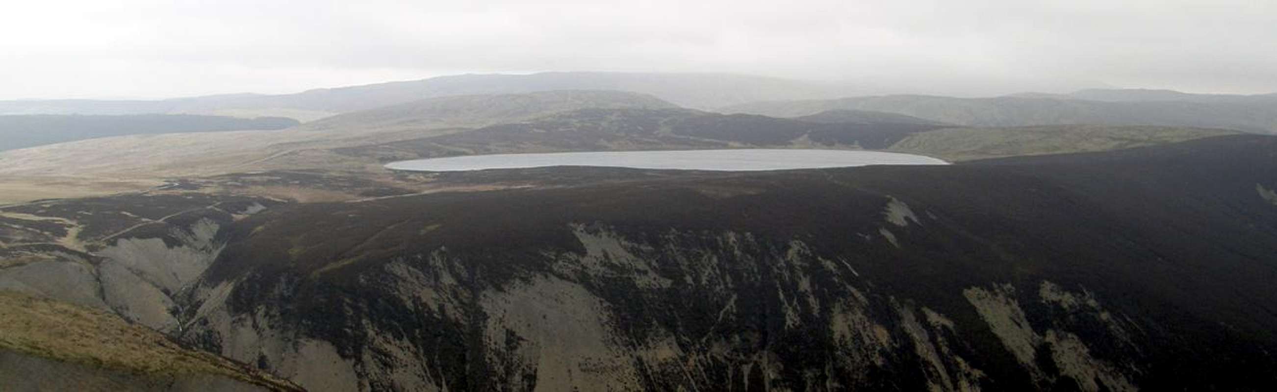  |
Foel Fadian is a point marked by an OS-Trig on a pinnacle of high land that juts out over what must be one of the most beautiful glacially cut valleys. This valley is dominated with steep cliffs guarding all its sides and tumbling with many waterfalls. From the summit trig point the commanding views into this valley are very impressive. The other features that stand out in view from here are the great mountain lake of Glaslyn and the mighty summit of Pumlumon Fawr with its satellite tops in the background. The lake of Glaslyn is part of a vast nature reserve which encompasses much of the isolated moorland, surrounding hills and valleys.
 From the road
 From Glaslyn lake
 From Penyglog
The best and most shapely view of Foel Fadian other than the views seen from its summit are from the shores of the lake at Glaslyn. From here Foel Fadian rises gently from the east then falls away in a dramatic and steep drop into the edges of the neighbouring glacially cut valley.
The hill itself is very easy to access and from parking on the near by mountain pass road takes about 20 to 30 minutes to reach the trig point on its summit. Once the summit is reached it is certainly worth walking down the steep edge of the hill to a path that follows the top of the glacially cut valley. From this path you can follow the edge of the cliffs all the way back up to the road via the lake of Glaslyn making a pleasant round trip.
When on the summit in the clearest of weather the views are rewarding for such a small hill. It was overcast and the views were not good when I was there on the 22nd March 2009 which was sad as I would have added the pictures on this page. There is always another time to visit it and although the views were not good I can say that from here on a clear day you can definitely see the summits of Cadair Idris, the Aran's and Pumlumon Fawr.
 View looking east
 Summit trig number
 View looking west
 Wynford Vaughan-Thomas memorial
A memorial was constructed not far from Foel Fadian next to the road at Rhiw Fawr in remembrance of the welsh journalist Lewis John Wynford Vaughan-Thomas. It was constructed after his death, completed and unveiled in 1990 in the form of a toposcope looking north-west out over the rolling hills and mountains of Wales, with a depiction of Vaughan-Thomas pointing towards Snowdon, Wales' highest peak, which is just visible on a clear day. From this view point the complete traverse of Cadiar Idris is also clearly visible.
Picture of Cadair Idris from the memorial via this link:-
Cadair Idris from the memorial
The memorial was constructed here, not because he had any connections with the area, but because he felt that the view from here towards Snowdon was the best in Wales.
Sadly when I visited the memorial on 22nd March 2009 it is currently undergoing maintenance work due to weather damage and vandalism. It will hopefully be back to its original state soon for other people to enjoy.
Glaslyn lake and nature reserve:-
A Really Wild Place…!Not only is this the biggest reserve currently managed by Montgomeryshire Wildlife Trust, 230ha ( 540 acres ), but it is also the wildest and most regionally important site.
Why is it so important:-
The reserve has several distinct habitat types, the largest being heather moorland. The trust is increasing the area of this valuable habitat at Glaslyn by returning an area of agriculturally improved grassland back to heather moorland.
The mix of heathers, bilberry and crowberry provide cover and food for red grouse, wheatear, skylark and ring ouzel.
Boggy areas of heather and rough grass with sphagnum moss, rushes and sedges are another habitat. Carnivorous plants including sundew and butterwort live in the bogs.
The lake here at Glaslyn does not attract a lot of wildlife because of the low nutrient levels of the acidic water. Diving ducks like golden eye do visit in the winter and one plant that does survive in the lake is quillwort.
The neighbouring glacial valley is a very harsh environment for any colonising wildlife with exposed rocks and unstable screed slopes. The springs in the valleys upper reaches are the source of the River or Afon Dulas which flows out to meet the River Dovey or Afon Dyfi at Machynlleth. It is advised not to stray off into this steep valley as it is very dangerous.
Birds of prey:-
Remember when here if you like birds of prey look up. Many birds of prey keep an eye on the heather moorland looking for rabbits and other small rodents. Often seen here in the Glaslyn reserve are red kite, merlin and peregrine falcons.
 A red kite looking for prey over the local countryside
Keep the area special:-
Now you know how important the countryside is and the nature that this reserve supports. So keep to the following to do your bit on helping.
- Keeping to the designated paths
- Not making to much noise
- Take all your litter hope
- Leaving the plants and flowers alone
- Not paddling or allowing dogs into the water
 Glaslyn lake
 Glacial valley
 From Foel Fadian
The nature reserve is open 24/7 as in all day and admission is free of charge.
Contact Address and numbers:-
Montgomeryshire Wildlife Trust, Collot House, 20 Severn Street, Welshpool, SY21 7AD
Telephone
01938 555654
Fax
01938 556161
Directions to Glaslyn nature reserve:-
Glaslyn reserve is situated on the minor mountain road between the B4518 near Staylittle / Penffordd-las and the A489 at Machynlleth. Follow a track for about a mile, and parking is available in a designated car park at the reserve entrance.
Getting there:-
The summit of Foel Fadian is within easy reach from the small section of road linking Llanidloes in the south and Llanbrynmair to the north via the small village of Staylittle / Penffordd-las.
 1:25 000 Map
 1:50 000
Llanidloes – Streetmap link
Llanbrynmair - Streetmap link
Staylittle / Penffordd-las - Streetmap link
Machynlleth - Streetmap link
The A470 is the main road linking the north of Wales at Conwy with the south of Wales at Cardiff which of course links with all the other roads that lead into Wales. The A470 I believe is the easiest road to head for from most parts.
From the north - Llanbrynmair:-
Once on the A470 from the north there is a small village called Llanbrynmair. From Llanbrynmair come off the A470 and take a small road called the B4518. Heading south towards a village called Staylittle / Penffordd-las. If you end up in Staylittle / Penffordd-las you have gone too far. Just before the village there is a road to the right which signposts Machynlleth via mountain pass. Take this road and follow it winding up into the hills until you reach the entrance track to the Glaslyn nature reserve. Foel Fadian stands proud in front of you. Car parking is available but restricted just a little further on where a memorial and viewpoint are on the left side.
From the south - Llanidloes:-
Once on the A470 from the south there is a small town called Llanidloes. From Llanidloes come off the A470 and take a small road from the town centre called the B4518. Heading north towards a village called Staylittle / Penffordd-las. Just after the village do not take the first turning left signposted Hafren forest but take the next left signposted Machynlleth via mountain pass. Take this road and follow it winding up into the hills until you reach the entrance track to the Glaslyn nature reserve. Foel Fadian stands proud in front of you. Car parking is available but restricted just a little further on where a memorial and viewpoint are on the left side.
From the west - Machynlleth:-
From the town of Machynlleth this small mountain road that has been mentioned in the previous directions links through from Staylittle / Penffordd-las.
From Machynlleth head east on the A489 then take the minor road signposted for Forge and Staylittle / Penffordd-las. Follow this road high up until you reach a memorial on the right hand side. You can either park here and walk up or continue to the entrance track for Glaslyn nature reserve.
View Larger Map
Rail services:-
The nearest rail services are the stations at Caersws, Machynlleth and Newtown. These are all on the main rail line from Shrewsbury to Aberystwyth. Shrewsbury has connecting rail services to and from other major cities such as Manchester and Birmingham which in turn have services to and from London.
Nearest airports are at:-
Birmingham International
Cardiff
Liverpool
Manchester
The Ordnance Survey Maps for this area are as follows:-
1:50 000 scale Landranger maps:-
Landranger 135 Aberystwyth and surrounding area.
Landranger 136 Newtown, Llanidloes and surrounding area.
1:25 000 scale Explorer maps:-
Explorer 215 Newtown and Machynlleth
1:250 000 scale Travel maps:-
Road 6 - Wales / Cymru and West Midlands
Ordnance Survey via this link:-
Ordnance Survey Home Page
Red tape:-
 Waterfalls and rapids deep in the glacial valley on the River or Afon Dulas
As with Plumlumon Fawr there is no red tape here, and even if there was there’d be no one around to enforce it. Although unlikely it is worth checking the countryside access map provided by the Countryside Council for Wales (CCW) regarding whether or not any restrictions on movement in the area are in place.
Countryside Access Map
Local towns - accomodation and camping:-
Local Towns:-The hill of Foel Fadian is relatively remote but in the lower valleys there are quite a few towns that accommodation can be found in. These are listed below and I advise you to add these towns into an internet search engine such as google and add in the search the subject such as, bed and breakfasts, youth hostels or camping and as you know the amount of information available will be endless. This is the easiest way of getting that information.
The main towns of interest are as listed below and these are active links to where they are on streetmap.
Aberystwyth:-
Dolgellau:-
Llanbrynmair:-
Llandrindod Wells:-
Llangurig:-
Llanidloes:-
Machynlleth:-
Newtown / Y Drenewydd:-
Rhayader / Rhaeadr Gwy:-
I hope the information I have put into this page is sufficient but if not there is a lot more available concerning this area in detail from the Cambrian Mountains page on Summitpost added by Nanuls.
Cambrian Mountains by Nanuls SP-Page via this link
Weather:-
Some off the information within this page is from Nanuls Pumlumon and Cambrian Mountain pages. This is because these are in the same area and share many similarities to each other. This information has been added with his kind permission.In the spring and summer the weather here is usually quite mild and although the weather is usually warm rain showers are a common occurrence. It is advised full waterproofs along with good quality walking boots are an essential. It can be very dangerous straying off to the cliffs in the vicinity of the valleys and in icy conditions do not go anywhere near the cliffs as there are drops of around 500 feet in places…!
In winter the area is much quieter as most tourists prefer to visit the area when it's warm. In winter conditions an ice axe and crampons should probably be carried. Despite the areas comparatively low altitude it can get very cold with temperatures dropping to near Arctic levels, many inexperienced walkers and climbers have been caught out in these conditions most are rescued safely by mountain rescue teams however occasionally the consequences are more serious.
The BBC has a detailed 5-Day forecast for various areas of Wales.
The nearest towns covered by this are as follows:-
Aberystwyth is to the west of Foel Fadian:-
Aberystwyth BBC 5-Day forecast link
Llanidloes is to the east of Foel Fadian:-
Llanidloes BBC 5-Day forecast link
Guide books:-
The Cambrian Way – the mountain connoisseurs walk by A.J. DrakeThe Mountains of England and Wales: Volume 1 Wales (Cicerone Guide) by John and Anne Nuttall
Hillwalking in Wales Vol 1 (Cicerone Guide) by Peter Hermon
Hillwalking in Wales Vol 2 (Cicerone Guide) by Peter Hermon
Useful links:-
 The dramatic glacial valley with its steep cliffs
 A stunning local waterfall near the town of Machynlleth
Cambrian Mountains Society
Carmarthenshire County Council
Ceredigion County Council
Powys County Council
Countryside Council for Wales
British Geological Survey
The National Trust
CADW
Royal Commission on Ancient & Historical Monuments in Wales
Cefn Croes Wind Farm Campaign
Top Trumps
An explanation of Top Trumps
Bogs
Bog Snorkelling
Wildfowl & Wetlands Trust
The Wildlife Trusts: Water and Wetlands
Mountaineering and Climbing Organizations
British Mountaineering Council
The Climbers Club
Tourist Information
Welsh Tourist Board
Mid Wales Tourism Partnership
Carmarthenshire Tourist Board
Ceredigion Tourist Board
Powys Tourist Board
Leaping Stiles
Pentir Pumlumon
Local Towns
Builth Wells
Aberystwyth
Lampeter
Llandovery
Llandrindod Wells
Llanidloes
Llanwrtyd Wells
Machynlleth
Pontrhydfendigaid
Rhayader
Tregaron
Weather
Mountain Weather Wales
Weather from the Met Office
Weather Channel UK
Travel
Welsh Public Transport Information
Uk Train Timetable
Accommodation
Hillscape: The Self-guided Walking Specialists
Youth Hostel Association in Wales
Dolgoch Bunkhouse YHA
Tyncornel YHA
Mid Wales Campsites
Maps and Guidebooks
Ordnance Survey
Harvey Map Services
Cicerone Guidebooks
Climbers Club Guidebooks
Welsh Language
Welsh Language Board
Cymdeithas yr Iaith Gymraeg Welsh language pressure group
Cymuned Welsh language pressure group
Yr Urdd (Welsh Youth Association)
Welsh-English / English-Welsh online translator
Welsh-English / English-Welsh Online Dictionary
Welsh-English / English-Welsh Online Lexicon