
-
 9090 Hits
-
 83.69% Score
-
 17 Votes
|
|
Mountain/Rock |
|---|---|
|
|
15.239°S / 72.641°W |
|
|
La Union |
|
|
Mountaineering |
|
|
Spring, Summer, Fall, Winter |
|
|
18038 ft / 5498 m |
|
|
Overview
 Cotahuasi Canyon, Arequipa, Peru
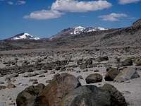 Firura In September
 Nevado Coropuna as seen from Laguna Alpalcocha
Nevado Firura is an extinct volcano situated in the Department of Arequipa, Peru. It is in the province of La Union, near the village of Cotahuasi, on the high plain above the Cotahuasi Canyon. Cotahuasi is 375 Km. from the city of Arequipa. For information about getting to Cotahuasi, as well as lodging there, check the Cotahuasi Canyon link above.
Although Firura is 18,038 feet (5,498 m.) high, it is only about 2,000 feet above the lowest point of the high plain, and only 1,500 feet or less, higher than the Alturas de Firura and Firurana which surround the mountain on most of three sides. The summit is located on the large humpback ridge, with a lower peak behind that, and a separate lower peak to the left of the summit. The mountain itself is non-technical and very easy to climb, especially when it is covered in snow. What makes it a difficult climb is the long access hike, although that can be shortened from two days to one day if you have a 4WD vehicle.
Firura is usually overlooked by climbers, probably because it is overshadowed by its higher neighbors, Nevados Solimana and Coropuna. Of all the locals and mountain guides that I have talked to, none of them have climbed, or who know of anyone, who has climbed, the mountain. However through a web search I found out that the University of Maine's Climate Change Institute has been studying the area around Firura for years. I wrote to them and received a reply from Gordon Bromley and he said that he and Kurt Rademaker did indeed reach the summit, by "toiling up that endless scree" on the north side, during the dry season in 2005.
It is not mentioned in the text of Jill Neat's book, “Mountaineering in the Andes”, although she does show it on a map. John Bigger only lists the elevation on his website. Given the ease of climbing it, I'm sure it was climbed by the Incas, and has probably often been climbed since by local herders who live up on the high plain. We went from our high camp, which was at the base of the mountain (16,900') to the summit ridge (17,800') in just under 1½ hours, arriving there just before dark. We returned to camp in about 50 minutes, under an almost full moon.
Getting There
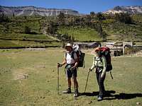
 The Road Up to Achambi
 Rocky Going Near the Base of the Mountain
The easiest way to climb Firura is to drive from just past Visca Grande (near Nevado Solimana, before arriving in Cotahuasi), past the Telefonica tower to Lagunas Apalcocha. This is at about 16,200', which makes a good base camp. Then follow a draw up to the high plain and you will see Firura. I feel like that is cheating by driving so high, so I prefer to hike up from Cotahuasi (8,800') or Tomepampa (8,857') or to drive up to an intermediate village and hike from there. There is a steep road with lots of switchbacks that goes from Tomepampa to Achambi (12,200'). An easier drive is to go from Cotahuasi to Locrahuanca (11,160') and then it's a bit over an hour's hike up to Achambi. There are many other ways to get up to the high plain as well, including walking trails and roads to Cahuana and Ayahuasi. A look at the topo map will show that there is no really good direct way, but any of the side canyons up from the Cotahuasi Canyon, between Cotahuasi and Alca, are possible.
The Route
 Starting in Achambi
 Above Achambi
 Follow This Ridge Up to a Notch
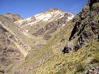 Looking Down From the Notch
 The Pasture Area, Turn Right Here
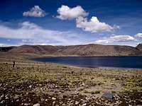 Stay To the Left of This Lake Going Up
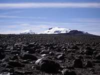 First View of Firura
 Follow the Valley To the Left of These Rocks
 Follow This Valley
 Almost To the Snow Line
The mountain can be climbed at almost any time of the year, but during the rainy season (January to March), be prepared for rain down lower and snow on the mountain. Visibility can be very limited during this time of the year with clouds at higher elevations. However there are stretches of nice weather, if you are prepared to wait out a storm. May through August can be quite cold on top, but there is more snow on the mountain in May and June, which makes climbing easier.
From Cotahuasi go up canyon to Tomepampa by car or combi and then drive or hike up to Achambi. From Achambi take the trail that goes southeast up a canyon to Lagunas Apalcocha on the high plain. There is a wide trail climbing up from the village to the pasture lands right above, but then the trail disappears until you get up above them. Follow the ridge up to the right of the main canyon. From here the trail reaches a notch at the highpoint, and then drops back down into the canyon and crosses to the other side of the creek. The trail is somewhat faint at times from here. The canyon will widen out in a pasture area, go to the right here and you will see the trail going up on the left side of the stream. The trail is fairly clear until you reach the high plain and see the lakes, then it is just a small path going to a herder's house on the right side of the lake. This is the end of the trail, it is all cross-country from here.
Once on the plain, go east, passing to the left of the largest lake and then up a draw to a higher plain. Here you will soon get your first view of Nevado Firura. Be sure to turn around and notice the two rocky points to the left of the canyon that you came up, these are your
return reference points. In spite of the lack of a trail, it is easy hiking cross-country on the barren, rocky plain. Go towards the small, lower peak of Firura,which is on the left, as it is easier to go around another higher plateau on the left than to go over it. You will drop down to a couple more lakes, then aim for a cliff on the far side of them. Go to the left of the cliff, and then go in the direction of the saddle between the peaks. You want to arrive at the base of the mountain, roughly below the steep bare rocks to the left of the summit. The summit is the (usually) snow covered highest point you see from here, but it will not be visible when you get to the base of the mountain.
You will see many rock carrins (most of which seem to have no meaning), and cross a number of trails, including a couple of wide ancient trails, but there are none going toward the mountain, so you just continue cross-country. You can generally follow a wide valley or draw, but there are numerous ups and downs, as well as meandering around – it is not a straight line! As you get near the mountain, there will be a couple of smaller lakes in a depression, and a ridge line running up over a higher area on the right. We stayed lower to the left, but it may be possible to follow the ridge and go high as well. These might be the last of the lakes, but I think we found a couple of small ponds beyond these. It depends on the time of the year as well. I did it the first time near the end of September and I think some of these were dry. It also depends on the exact route you take, the terrain is so rough and rolling that from a slightly different route you might not be able to see some of the small ponds.
Once you are at the base of the mountain, the route to the summit is directly up the broad face of the mountain. The true summit is out of sight, on the left end of the larger mountain (there is a saddle and a lower peak to the left of that). The summit climb was very easy with the heavy snow pack in May. It would probably be rock hopping on large boulders without the snow, just like the approach. It was quite rough going on the rocks, mostly boulder hopping on large sharp rocks. Most were fairly stable, but there were always a few loose ones to keep you on your toes. It was much easier going once we got to the snow, which was in perfect condition at 5:00 pm. We did not use crampons or an ice ax, just trekking poles, as we could easily make good tracks with just our boots. Early in the morning, would probably be a different story, as during the night it got down to below 20° F.
Camping
 High Camp
 Lots of Lakes and Ponds
 Heading For the Summit, Hidden Behind the Knob
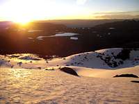 A Nice Sunset, but Running Out of Time
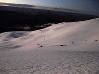 Getting Dark and Getting Cold
 Summit Ridge
There was no water a the base of the mountain when I was there in September. In the beginning of May, there was a small stream coming down from the snow, not too far above where we camped. We found a nice flat tent site at 16,850', about 30 minutes below snow line, as we were going up the draw towards the left of the summit. On my second climb, I missed that site but found another one about 15 minutes above that, at 16,980'.
From Achambi to the high plain, there are very few level areas, it is mostly a steep climb. There is a grassy plain about 2/3 of the way up, however it is mostly sloping. I found one small campsite there, above a boulder near a small spring (very good water here). On the high plain, before you get to the base of the mountain, you can camp almost anywhere. Camping would be possible near most, if not all, of the small lakes on the high plain. There are a few herders living up there, but no villages above Achambi. There are cattle and llamas as well as wild vicuña and deer. We treated our water with Aqua Mira, but when drinking it noticed very small reddish bugs swimming in it, as well as a few small worms. We filtered them out with a T-shirt.
There are no hostels in Achambi, although you might be able to stay in someone's home. I have camped outside of the village, too many dogs in the village. There is one hostel in Tomepampa and many in Cotahuasi. Buy your supplies in Cotahuasi, or for better selection and cheaper prices, in Arequipa.
Other Information
 Laguna Alpacocha at Sunset
 Going Back Down to Achambi
Total time for the hike and climb from Achambi is three to four days. It is possible to return from high camp to Achambi in one day. Currently (May, 2009), there is no combi service to Achambi. The road is OK during the dry season, but might require 4-wheel drive during the rainy season. It is a steep, narrow mountain road, with lots of tight switchbacks, and few places to meet or pass anyone. Thankfully there is almost no traffic! Which of course isn't good if you are trying to hitch a ride.
Cell phone coverage: There is no coverage from just past Cotahuasi with either Claro or Movistar. I thought there might be Claro coverage on the summit, but my phone said "emergency use only". There is a Mifono satellite telephone in Achambi, which requires a special phone card to use. They are usually available at the house where the phone is located. There is a sign on the building showing where the phone is located, but you have to go around the building to find the entrance.