Peak which offer easiest ascent and one of the most beautiful view on Durmitor
The peaks of Southern
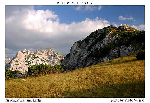
DURMITOR are separated from the highest Durmitor's peaks called Soa Nebeska with deep and beautiful Škrka Lakes Valley. The highest peak of Southern Durmitor is Prutaš, but in its neighbourhood exist one peak which is not well known, even it offer incredible enjoyment in beautifully panoramas od Durmitor's massif. That peak is called
Raklje (2159 m) and it is placed SW from Prutaš, its neighbour Gruda and Krecmani, on SW side from Šareni Pasovi, and on SW side from Bobotov Kuk, Bezimeni Vrh and Djevojka.
Few people know that Raklje peak offer one of the most beautiful and most impressive view to the highest peaks of Durmitor which hanging above the emerald beauty of Škrka Lakes Valley, where are placed two beautifully lakes, Veliko Škrčko Jezero (Large Škrka Lake, 1686 m) and Malo Škrčko Jezero (Small Škrka Lake, 1711 m). Raklje and its slopes offer maybe the best view to Durmitor's beautiful massif and its highest peaks. Also, Raklje offer very wide view to three canyons - Sušica, Piva and Tara. Specially nice view is to deep and impressive Sušica Canyon which is cutted between the high cliffs on the western side from Raklje. Also, we can't forget on beautiful W summit view to impressive range Maglic/Bioc/Volujak which dominate above the Piva Canyon.
For sure, Raklje is the peak which offer the easiest ascent and one of the most beautiful view to the magnificent and powerful massif of DURMITOR.
Routes Info
![Raklje summit ridge]()
The ascent on Raklje peak is maybe the easiest ascent from all of Durmitor's peaks. This route is really for everybody, because the terrain is mostly grassy. The height difference between Todorov Do valley (about 1700 m) and Raklje summit (2159 m) is about 450 m. The path is not steep and is it possible to reach the summit after maximum 1h of walking.
You can parking your car on the asphalt road in Todorov Do below the Raklje massif. From here you can start your ascent on Raklje. The easiest and shortest ascent on Raklje starts from Todorov Do, going on the left side below the SW side of Raklje massif accross the pass. From that pass continue to the right below the NE side of Raklje. You will see whole Raklje massif and in the middle part of it you'll notice wide grassy coluour. Ascending through this coluour you'll very soon stay on the summit ridge, from where you can continue your ascent in the summit direction. Below the grassy coluour you can camping on wide and beautiful grassy plateau with a nice view to Durmitor's massif.
![Raklje slopes]()
When you walking on summit ridge to the summit of Raklje, you can whole time enjoy in amazing views and panoramas of DURMITOR and its peaks, valleys, lakes and canyons. Of sure, the most impressive view is in N-NE direction, to Škrka Lakes Valley which as a diamond stay between the Bezimeni Vrh, Bobotov Kuk and Planinica on the N, Djevojka and Šareni Pasovi on the NE and Prutaš and Gruda on the S. Also, from Raklje you can admire the view to Sušica Canyon and its natural connection with Škrka Lakes Valley, where the Skakala Waterfall is placed. You can see it during Spring and early Summer.
![]() Approaching Raklje |
![]() Below the Raklje |
![]() On the summit |
Summit View
![]() NE view |
![]() Sušica Canyon |
![]() Škrka Lake |
Getting There
Gateway to
Durmitor National Park and
Raklje (2159 m) peak is
Zabljak (1456 m) town. Information how to get there:
By Plane
~To
Beograd (Belgrade, Serbia&Montenegro capital) airport. Than with plane to Podgorica, capital of Montenegro, or with bus or car to Zabljak town.
~To
Podgorica airport. Than with bus or car to Zabljak town.
Information about flights find on the sites of
JAT Airways, a former Yugoslav airlines, or on
Montenegro Airlines.
By Bus
~
Beograd (Belgrade)-
Zabljak
~
Podgorica-
Zabljak
~
Niksic-Zabljak
~
Pljevlja-Zabljak
Buses go to Zabljak from Beograd (Belgrade) twice a day and from Podgorica, Niksic, Pljevlja and Mojkovac several times per day.
By Car
~
Beograd (Belgrade)-
Zlatibor-Nova Varos-Prijepolje-Pljevlja-Zabljak
~
Niksic - Savnik (47km) - Zabljak (37km): 84km; Niksic to Zabljak approach from south.
~
Niksic - Savnik (35km) - Zabljak (37km): 72km;
~
Podgorica - Niksic (55 km)-Savnik (47 km)-Zabljak (37 km): 139 km; Add this length if you are going to Zabljak from Podgorica via Niksic. Road to Niksic from Podgorica is good.
~
Podgorica - Kolasin (71km) - Mojkovac (21km) - Zabljak (67km): 159km; road is good all the way to Zabljak. Behind Podgorica (56m) you go inside Moraca River canyon (one of spectacular Montenegrin canyons). It is up to 1000 m deep and has wild sides. That's spectacular drive. After that, from "Djurdjevica Tara" bridge to Zabljak - 23 km.
Camping
Optimal place for camping near or below the Raklje massif is
Todorov Do valley. Also, you can freely use your tent below the NW side of Raklje on the beautiful grassy plateau. The nearest
water spring is
Pištet spring in Todorov Do below the Prutaš peak.
Meteo Info
Meteo info for Durmitor and Žabljak town you can check
VREME YUBC NET web page.
Red Tape
No extra fees.