
-
 10651 Hits
-
 85.87% Score
-
 21 Votes
|
|
Mountain/Rock |
|---|---|
|
|
48.43635°N / 113.36899°W |
|
|
Mountaineering |
|
|
Summer, Fall |
|
|
8581 ft / 2615 m |
|
|
Layout designed for best viewing on a "1024 x 768" screen.
 Glacier National Park's Mount Ellsworth
 Antartica's Ellsworth Mountains, TRP photo
Billy or Lincoln?
Mount Ellsworth may be named for a guy named Billy or a fellow named Lincoln – you decide which story is more credible. There are no definite answers regarding the true namesake of Mount Ellsworth … which perhaps is actually best.
Shrouded in mystery and legend is not a bad place to be for a mountain.
A fellow named Billy:
According to the original Glacier National Park surveyor R. T. Evans; Mount Ellsworth is named for an early Glacier packer named Billy Ellsworth. That’s all that is known about this mystery man. But R. T. Evans should know; he was there when it all began.
Or a guy named Lincoln:
Glacier National Park’s Mount Ellsworth may be forever linked with Antarctica’s, Mount Ellsworth, which rises 9,596 feet above sea level. The one in Antarctica certainly is named for Lincoln Ellsworth.
Ellsworth’s first claim to fame was in 1926 when he participated in the Norwegian explorer Roald Amundsen’s 2nd Aerial Expedition to the North Pole. On May 12, 1926 they spotted the North Pole. This was the first undisputed sighting of the North Pole.
Is it possible that the peak was named for this American explorer?
According to Jack Holterman’s book, Place Names of Glacier National Park, Lincoln Ellsworth was in the park in about 1911 and returned again in 1926.
According to the Glacier National Park Administrative History web site…
“Glacier has had several whose claim to fame has had world-wide recognition. One of the first of these internationally known figures was Lincoln Ellsworth, who later was the guiding financial genius for the Amundsen polar expedition of 1926. Ellsworth first visited the park in 1911; for about a month he traveled over the area accompanied by Ranger James C. Graves. He returned in 1912, and again in the summer of 1926, when Captain Roald Amundsen, the famed North Pole flier, and his crew from the dirigible "Norge," stopped briefly at Glacier Park Station, on their way from Alaska, following their successful flight over the North Pole. The flight from Nome, over the North Pole and down to Alaska was one of the famous polar flights, and the first successful one over the pole. With the captain and his crew was Lincoln Ellsworth.”
Lincoln Ellsworth also made four aerial expeditions of Antarctica where he made a Trans-Antarctic flight from Dundee Island to the Ross Ice Shelf. Accompanying Ellsworth on these flights was pilot Herbert Hollick-Kenyon. His record making flight covered 2,200 miles in about 20 hours. During these flights Ellsworth claimed over 300,000 acres for the United States.
Ellsworth is also tied to the naming of the Sentinel Range and the Heritage Ranges which make up the Ellsworth Mountains. Total land area is 200 miles (360 km) long and 30 miles (48 km) wide. Vinson Massif at 16,050 feet (4,892 m) in the Heritage Range is the highest in Antarctica.
Source: South-Pole.com
Which story is more believable is your decision. Both have merit and both are equally credible.
And what we do know for sure:
What we do know is that George Schultz said that this mountain was called “Buffalo Child” or “Inokos” in honor of a Blackfeet man.
Overview:
 Ellsworth and Never Laughs, saintgrizzly photo.
What makes Mount Ellsworth a desirable destination?
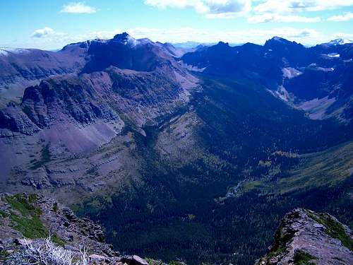
It is located in the beautiful Two Medicine Valley and provides views into the Nyack region, towards Marias Pass as well as towards Logan Pass and St. Mary’s. Ellsworth is frequently climbed in the same day as Never Laughs Mountain.
From its summit the seldom seen peaks of the Ole Creek Drainage can be seen in addition to Bearhead Mountain. Buttercup Park with its cirque-like southern walls folds out below Grizzly Mountain and Painted Teepee Peak. To the east is the Midvale Creek drainage between Mount Henry and Dancing Lady Mountain.
J. Gordon Edwards has published a route for Mount Ellsworth in A Climber’s Guide to Glacier National Park.
Edwards’ description of the route is found on pages 318-319. Edwards writes that this mountain can be accessed by several possible routes such as Aster Park, Scenic Point Trail, Mount Henry, and from the south along the traverse from Firebrand Pass to Two Medicine. Edwards only includes The Scenic Point Route to Mount Ellsworth in detail.
Edwards also notes that an enjoyable descent from Ellsworth to the summit of Never Laughs can be made in a matter of minutes (actually about 30 minutes). He then suggests descending from the saddle between Never Laughs and Ellsworth into Aster Park, which would eventually connect with the Aster Falls trail as described below.
Route Statistics:
Edwards published that there is an elevation gain of 3,500 to 4,000 feet and a distance of 12 miles with 3 or 4 miles traveled on trail.
 |  |
|---|
 |  |
|---|
Getting There:
 Looking at Ellsworth from Chief Lodge Pole Peak near Two Medicine Pass.
To visit Glacier National Park is to enter a place where Heaven touches Earth affording brief glimpses into the Wonders of Creation.
The "Crown of the Continent" is located in northwestern Montana and shares a border with Waterton International Peace Park in Canada. Driving the world renowned Going-to-the-Sun Road to Logan Pass is a great way to see Glacier. Typically Logan Pass and Going-to-the-Sun Road opens near the end of June but it can be as early as the middle of June and as late as after July Fourth. If you drive Going-to-the-Sun Highway you still will not reach the fabulous Two Medicine Valley. It is a little out of the way and perhaps as a result receives fewer visitors than other portions of the park.
The Two Medicine Valley which typically opens before The Going-to-the-Sun Highway is located near East Glacier, Montana and is most easily accessed via U.S. Highway 2 which crosses Northern Montana east to west. The Two Medicine Valley is the location of Two Medicine, Dawson, Pitamakan and Cut Bank Passes. It is also home to Sinopah Mountain which is perhaps the park’s most photographed peaks.
Driving Instructions from East Glacier, Montana:
After reaching East Glacier, Montana on Highway 2 and travel 4 miles (6.44 km) North on State Highway 49 to the Two Medicine turnoff. Drive to the end of the road and park in the Two Medicine Parking lot.
Driving Instructions from St. Mary’s, Montana:
Travel south on Highway 89 to Kiowa Junction, turn right on to Highway 49 and continue 9 to the Two Medicine turnoff. Drive to the end of the road and park in the Two Medicine Parking lot.
Go to Plan Your Visit road conditions, road repairs and delay schedules as well as estimated opening information.
Two Medicine Trail Map
Glacier Map
Red Tape:
 View from Ellsworth looking to Appistoki Peak and Mount Henry (on right)
For current National Park Entrance Fees: Current Park Information
For all the Rules and Regulations governing Glacier National Park look at the Rules and Regulations. It’s always a great idea to read these rules before planning a trip to Glacier National Park. Regulations change from year to year and generally the “I didn’t know about that” excuse does not work as the Federal Government governs the park. Read the rules and regulations and be informed.
You do not have to register for day climbs in Glacier National Park but it is recommended. Backcountry travel regulations can be found at Backcountry Travel. There is also information from the Park Service on Mountain Climbing in Glacier.
As with all hiking and climbing in Glacier National Park use caution and practice good manners with the wildlife. You are in bear country. Carry your bear deterrent, don’t hike alone and make some noise. For more information please go to the Park's website for Bear Information. The U.S. Forest Service also has helpful information on Grizzly Bear Management.
Following the Trail to the Off Trail Route:
 Ellsworth and surrounding peaks from Sinopah, echoguy photo
The route is rated by Edwards as class 2, with occasional class 3 stretches.
Volume Two of Climb Glacier National Park has more details on Mount Ellsworth and suggested routes. It can be ordered at Climb Glacier National Park.
The published route from Edwards suggests traveling up the Scenic Point Trail to a switchback above Appistoki Creek.
The Scenic Point Trail is located on the south side of the Two Medicine Road just before arriving at the campground and store. There are signs designating the turn onto a gravel road. There is adequate parking and the trailhead takes off on the east side of the gravel parking lot.
The trail is easy to follow and within a short distance a spur trail leading to an overlook to Appistoki Falls takes off to the right. Stay on the left and work along the woods on the south side of Appistoki Creek through a nice series of switchbacks. Eventually Appistoki Creek will be far below and the trail heads west for about ½ mile.
Soon the cirque below Mount Henry opens up and a switchback turning north is reached. It is from this switchback that the off trail portion of the route begins.
It is also possible to continue up this trail and summit Mount Henry from the Scenic Point Ridge Walk as described on the Mount Henry page. See the Scenic Point Route to Mount Henry for more information on this approach.
Eventually the Scenic Point Ridge Walk route joins in with the route described below. That should be self explanatory but just in case the routes rejoin on the north side of the unnamed peak as mentioned below.
Off Trail Route Information:
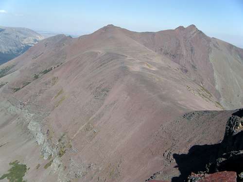
 Ellsworth from Point 8650
After leaving the trail at the switchback try to maintain elevation while heading under the face of Mount Henry rather than loose elevation. It is also possible to drop down and follow Appistoki Creek into the valley underneath Mount Henry. Eventually the elevation lost will need to be regained plus quite a bit more to the saddle to the south of Appistoki. A side trip to the twin summits of Appistoki will take an additional 30-60 minutes round trip from this saddle. See the Appistoki Peak - Appostoki Creek Route for more details.
As Edwards suggests climbing the goat trail to the south that follows the ridge to the west side of the unnamed peak (USGS Point 8650); this is easy and can be accomplished rather quickly. A long push uphill push along the ridge which eventually forms into a goat trail on the ridge will lead to the unnamed mountain just to the north of Mount Henry.
From the west side of the unnamed peak it is easy to summit Mount Henry. Loop around the south side of the unnamed peak and follow the goat trail eastward to the summit. This side trip will take about 45 minutes if you walk slowly. It will be necessary to gain some elevation as well as work around a small point on the ridge but a decent goat/human trail follows the ridge for the entire distance until the final push to the summit.
From the unnamed peak (USGS Point 8650) walk west to the next point before descending into the saddle between here and Ellsworth. It is another mile or so of ridge walk to the summit of Ellsworth.
Next achieve the summit ridge. I found it easiest to stay on the ridge closest to the cliffs below Ellsworth. The footing is better near the cliffs as opposed to the looser scree on the open slope.
There is also a goat trail that leads towards Ellsworth that takes off from near the Appistoki saddle. Avoid the temptation to follow it as it ends in a number of cliffs that would obviously take time to climb through and would more than likely necessitate climbing to the goat trail on this ridge anyway.
There is little difficulty in the rest of the route. Route finding as well as navigation to Ellsworth is uncomplicated as the summit of Ellsworth is clearly visible for a large portion of the ascent.
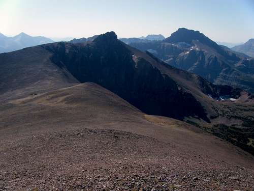
 Ellsworth from East
 Ellsworth from West
Special Considerations: The rock in Glacier Park is widely varied and it is not unusual to find several different types of rock on any given route. Know your rocks and be certain of your safety. J. Gordon Edwards has an excellent section in his guidebook on rock and climbing safety. Be safe and know your limitations as well as those who are climbing with you. Also refer to the following links for further details: GNP Rock and Grading System and the GMS Climbing Guidelines.
Return Routes or Routes to Other Areas/Peak:
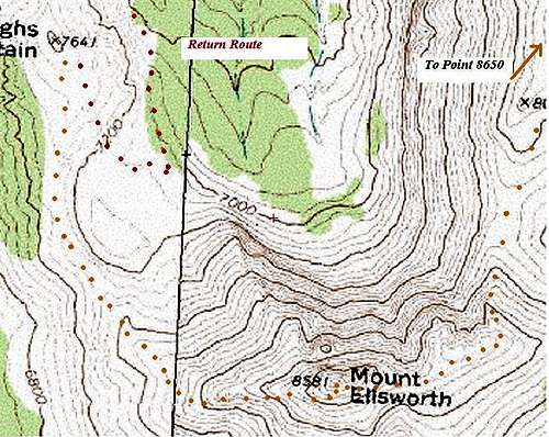 Basic Route Map
Option I:
Retrace your route to the unnamed peak and cruise down to the Appistoki saddle. Summit Appistoki Peak and add another one to your Glacier Summit list.
Option II:
Return to the unnamed peak and follow the reverse route for Mount Henry. The only tricky part here is getting off the summit dome. This is not difficult after down climbing through the first set of cliffs just south of the summit dome. Work down to the right then left through the scree filled slopes for about 90 feet of elevation loss and then scramble up the climber’s trail to the ridge between Mount Henry and Medicine Peak. This topo map shows the route.
One can also climb across the arete below Henry with little difficulty. See the Arete Route for photos and information.
Option III:
Continue down the northwest slope of Mount Ellsworth to Never Laughs Mountain and summit it. As you summit feel the joy of laughing on the summit of Never Laughs Mountain. Follow the descent route descriptions found on the Never Laughs Mountain page.
Option IV:
A long walk along a goat trail to the south and west along the Continental Divide will eventually lead to Firebrand Pass. From Firebrand Pass follow the hiking trail to eventually arrive at U.S. Highway 2 east of Marias Pass. It is possible to do Option IV in one day and that is how most people do it.
This could possibly be an overnight trip if desired and a back country camping permit would be required.
When to Climb and Weather:
This route is passable as soon as the roads are open in the Two Medicine Valley. There may be snow in the cirque below Mount Henry but generally that snow is gone by July. If following the Appistoki Creek Route it is not necessary to cross Appistoki Creek so high water is not an issue. There are adequate places to cross the creek if desired.This route would be rewarding in early summer when Glacier’s flowers show their first bloom. Later in the summer the prairie seems to dry out and there are less flowers.
There are bridges at the Aster Creek crossing along the South Shore Trail along Two Medicine Lake.
Gear and Camping:
Crucial gear includes: bear deterrent spray, water, sturdy footwear and a camera. Trekking poles are also helpful to protect those knees and give more security during the descent on Glacier’s scree filled slopes.A map and compass come in handy at identifying Glacier’s many peaks that can be seen from Ellsworth.
Snowshoes, Crampons and other gear would may be beneficial if done early in the season.
There is a park campground at Two Medicine
Other options for camping include:
GNP Campground Information, USFS Campgrounds, Camping on the Blackfeet Reservation or East Glacier Campgrounds
Links:
Glacier National Park in PicturesGlacier Mountaineering Society
Two Medicine Trails
Visit Montana