
|
|
Mountain/Rock |
|---|---|
|
|
35.77382°N / 52.19167°E |
|
|
Mountaineering |
|
|
Summer |
|
|
13189 ft / 4020 m |
|
|
Overview
Elevation Note:The elevations used in this text are per my GPS measurements. The Iranian 1:50 000 Map gives an elevation of 4010 m for Angemar II Peak.
Click to see a Map of the Dobrar Ridgeline.
Dobrar Ridgeline:
Dobrar (Ghareh Dagh) Ridgeline is an impressive 52 Km long mountain chain that forms a continuous wall in the southeastern portion of the Central Alborz Mountains of northern Iran. This ridgeline gives rise to more than 20 named peaks and many other unnamed high points. The elevations of 5 of these peaks exceed 4000 m. The highest of these peaks is the 4072 m summit of the West Dobrar Peak. The ridgeline starts near the Emamzadeh Hashem Pass on Haraz (Tehran-Amol) Road and heads east to end near the village of Seh Band on Firooz Kooh (Tehran-Sari) Road.
 Dobrar Ridgeline
Angemar II Peak:
 Angemar II
Angemar II is a mountain with many summits made of high points that rise on the crest of the Dobrar Ridgeline. The elevations of three of these high points exceed 4000 m. West to east, the high points are as follows:
1) Point 4020 m (35:46.429 North, 52:11.500 East)
2) Point 4015 m (35:46.335 North, 52:11.568 East)
3) Point 4010 m (35:46.127 North, 52:12.034 East)
Point 4020 m is the official summit of Angemar II and the other nearby high points (including the ones that are lower than 4000 m) can be thought of its sub-peaks.
To the east, Angemar II is connected to the 4047 m Angemar I Peak via a 3930 m saddle and to the west, Angemar II connects to the 3750 m Parvaneh Peak via a series of unnamed high points. The northern slopes of Angemar II go down steeply to the bottom of the Lasem River Valley (2500 m) and its southern slopes drop down to the bottom of the Tar River Valley (also 2500 m).
Angemar II can be climbed via its northern slopes starting in the village of Lasem (2550 m). Most climbers, however, reach Angemar II as a part of a multi-day traverse of the Dobrar Ridgeline.
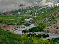
 Angemar II from Lasem Village
Wilderness Skiing:
The northern slopes of Angemar II have become a popular destination for wilderness skiers. The best time to ski the area is in late March and early April. You can ski from the top of Point 4010 m down to the 2550 m village of Lasem. The best ski route follows the valley that goes between Point 4010 m and Angemar I Peak. In June of 2009 (a year with better than average spring snow cover), we found continuous ski-able snow down to an elevation of 3150 m. From the village of Lasem, skiers hike up the steep slopes of the mentioned valley to reach Point 4010 m.
Route:
This route describes a traverse of the Dobrar Ridgeline from the summit of Point 3905 m to the 3930 m saddle between Point 4010 m and Angemar I Peak. Total hiking distance from the summit of Point 3905 m to the top of Point 4010 m is 2.0 Km.
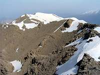
From the top of Point 3905 m, head east and hike down a little and then up to the top of Point 3965 m:
 Point 3965 m, West Face Point 3965 m, West Face | 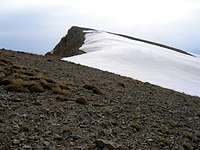 Point 3965 m, East Face Point 3965 m, East Face |
Hike down a little and then up easy slopes to reach the top of Point 4020 m:
 Point 4020 m, SW face
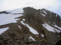
Views from the top of Point 4020 m:
 Dobrar & Angemar I Dobrar & Angemar I |  Points 4015 m & 4010 m Points 4015 m & 4010 m |  Looking West Looking West |
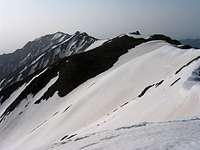
Follow the ridgetop southeast to reach the top of Point 4015 m:
 Point 4020 m Point 4020 m |  Point 4015 m Point 4015 m |
Views from the summit of Point 4015 m:
 Dobrar & Angemar I Dobrar & Angemar I |  Point 4020 m Point 4020 m |  Town of Damavand Town of Damavand |
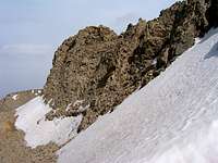
Continue to follow the ridgetop southeast to reach Point 4010 m:
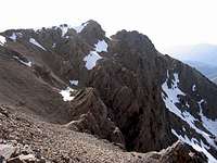 Point 4010 m, SW Face Point 4010 m, SW Face |  Point 4010 m, NW Face Point 4010 m, NW Face |
Views from the summit of Point 4010 m:
 Points 4020 m & 4015 m Points 4020 m & 4015 m |  Tar Lake & Zarrin Kooh Peak Tar Lake & Zarrin Kooh Peak |  Mt. Damavand Mt. Damavand |
Continue to follow the ridgetop east to reach the 3930 m saddle:
 Ridgetop Ridgetop | 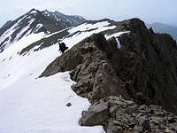 Dobrar & Angemar from Ridgetop Dobrar & Angemar from Ridgetop |  Point 4010 m from Ridgetop Point 4010 m from Ridgetop |
The 3930 m saddle between Point 4010 m and Angemar I Peak:
 From the Saddle From the Saddle | 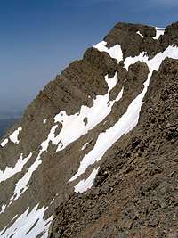 From the Saddle From the Saddle |
Ski descent to the village of Lasem:
Hiking distance from the 3930 m saddle to the village of Lasem is 5.0 Km
In June of 2009, there was skiable snow down to an elevation of 3150 m
Pictures of the slopes above 3150 m (June 2009):
 |  |  |
 |  |  Village of Lasem Village of Lasem |
Pictures of the slopes below 3150 m (June 2009):
 |  |  |  |
 |  |  Lasem Village Lasem Village |  |
Getting There
Click here for directions to the trailhead for Bazm Chal Peak, the usual access point to the top of the Dobrar Ridgeline.Directions to the village of Lasem (direct access to the northern slopes of Angemar II):
From eastern Tehran, drive the Haraz Road roughly 55 Km to reach the 2700 m Emamzadeh Hashem Pass. Continue north roughly 15 Km down into the Haraz River Valley past the town of Poloor until you see a side road on the right. Turn right and follow the road 17 Km uphill to reach the village of Lasem.