
|
|
Mountain/Rock |
|---|---|
|
|
46.35407°N / 8.71392°E |
|
|
Val Verzasca |
|
|
Hiking, Mountaineering |
|
|
Spring, Summer, Fall |
|
|
8976 ft / 2736 m |
|
|
Overview
 Summit Pyramid
 East Face
 South Face
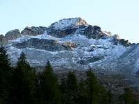
Monte Zucchero is one of the highest and one of the most appealing summits in the Verzasca area. Located far north in the Valle Verzasca it is far away from the big tourist attractions like the Lago Maggiore and the ancient Roman Ponte dei Salti bridge. Most visitors turn around at this point although the real beauty of the Verzasca area is beyond this point.
Following the only road in the valley towards the north the terrain becomes more rugged and more important: more beautiful. Finally the road ends at the beautiful town of Sonogno (see image below) where you will get the first sight of Monte Zucchero. My guess is that any climber (and hiker) who stands eye in eye with this beautiful pyramid shaped peak feels the immediate desire to conquer this mountain. With its 2735 meter it is the second highest peak in the area after Madom Gross (2760m) and towers almost 1800 vertical meters above the valley floor. Because of its isolated location it is not as often climbed as other 'easier to reach' peaks like Pizzo di Vogorno.
Zucchero offers two main routes up to the summit. The first one starts in the Village of Brione, a small town which you cross earlier when you are on your way to Sonogno. The route leads trough the Val d'Osola and approaches the mountain from the south.
The second route starts in Sonogno and approaches the mountain from the east. Both are graded T3/T4 and therefore accessible for every experienced hiker. Summit views are overwhelming. Towards the south the Verzasca valley is visible and in the other directions many 2500m+ peaks and the highest peak of the middle Ticino: Pizzo Campo Tencia (3070m) make up for a beautiful view.
 Sonogno and Monte Zucchero (East Face) Sonogno and Monte Zucchero (East Face) |
1: Brione Route
 Brione & Sonogno Route
  TOPO MAP: Brione Route in Red
The first route starts at the village of Brione (850m). The route is marked with red-white-red stripes and is graded T2. From Brione the route heads towards the north into the Valle (valley) d'Osola. This valley is free of roads and has to be crossed from start until end. The total length of this first part is about 7 kilometers, but the elevation gain is minimal. At the end of the valley the route becomes slightly steeper when you head up to the nice cabin called Alpe d'Osola (1418m).
You will find yourself now at the south side of Monte Zucchero and head up to Corte del Sambuco at about 1900m. The views towards Zucchero are great at every point on the route. From Corte del Sambuco the red-white-red marked route heads up towards the summit 2735m which you will reach over the SW ridge. This last part is graded T4. Descent is the same way down or alternatively descent towards Sonogno is possible.
2:Sonogno Route
 Zucchero from above Sonogno
 Sonogno
The second route starts at the village of Sonogno(930m). From Sonogno you will head towards the west into the Redorta Valley. This route is also marked by red-white-red stripes.
At the end of the valley you will continue to head west in the direction of Monte Zucchero which is in sight at all times. From the end of the vally the route starts gaining elevation and is still marked by red-white-red stripes. Finally you will reach the summit over the SW ridge.
How to get There
 South Face
 val d'Osola from the Summit
The A2 highway crosses Switzerland from north to south. On this highway take exit 'Locarno'
Follow the Locarno signs for several miles on this secondary road.
After a few miles there will be signs saying: Val Verzasca. This will lead you to Val Verzasca.
In the Verzasca valley is only one major road. You follow this road and you will first pass the village of Vogorno, than you will pass Lavertezzo and the 3rd major village is Brione (start for route 1). Here the road splits up: Follow the road to the east towards Gerra, Frasca and Sonogno. You will reach Sonogno (start for route 2) where the road ends.
Practical Information
Climbing Monte Zucchero does not involve any gear. The climb is graded T4 Some alpine experienced is advised.Note:
The altitude difference from the valley floor (staring point) until the summit is quite large. The climb includes an elevation gain of over 1700 vertical meters. Therefore, a good physical condition is advised.
Camping & Hotel
 Final Part (SW ridge)
 Winter view from Rif. d'Osola
Camping Al Censo, Claro.
A beautiful campsite on less than half an hour drive from Verzasca.
For more info:
camping Al Censo
The nearest Hotel is in Vogorno:
Hotel Pizzo Vogorno
Weather & Links
Click for WeatherVal Verzasca Tourist office
6598 Tenero
Tel +41 (0)91 745 16 61
Info@tenero-tourism.ch
www.tenero-tourism.ch
Official Ticino Site