
-
 2784 Hits
-
 80.49% Score
-
 12 Votes
|
|
Mountain/Rock |
|---|---|
|
|
44.67920°N / 108.0689°W |
|
|
Hiking, Scrambling |
|
|
Spring, Summer, Fall, Winter |
|
|
4490 ft / 1369 m |
|
|
Overview
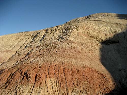
 Peak 4490
Peak 4490 is a striking badlands mountain that is located near the Bighorn River in the shadow of the northern Big Horn Range. One of the more beautiful formations of its kind in the Big Horn Basin, this peak features a multi-colored band that runs along the entire western side of the mountain. These colors range from various whites and grays to reds and purples and can be seen in the picture at right as well as in the Google Earth image below.
It takes a drive of about 40 minutes to reach this area from the town of Lovell, Wyoming. It takes about the same amount of time (or less) to summit this peak, but the reward of a small summit with expansive views of the Big Horn Range makes the trip worthwhile. The short scramble is pretty fun as well, and you could find some Class 3 ground if you have some time to play around and explore.
 Colored bands
Getting There and Climbing Information
 Class 2 gully
 Summit view north
From Lovell, Wyoming, travel east on Highway 14A and turn left (south) on Crystal Creek Road, which is 3.1 miles after you cross the bridge over Bighorn Lake. Once on the dirt road, drive for 10.1 miles and take the right fork, at which point you will reach a fork. Both roads connect with each other again after a mile or so. After another couple of miles, you will see a road sign at a fork where the main road turns right. Peak 4490 is off to the left as you make this right turn. There is a small two-track road that heads left towards the peak that will get you a little closer to the peak than parking off the main road.
 Cliff bands near the summit
Hike towards the northwest side of the peak and find the Class 2 gully that ascends to just below the white band that runs around the peak. Carefully scramble up the slick badlands formation to one of the breaks in the cliffs at the top; after gaining the flat area on top, head right towards to summit, which is a large boulder with a cairn on it. This peak looks much steeper and harder from the bottom than it actually is, but care is still needed on the harder ground.
A round trip hike up Peak 4490 is about one mile with 500 feet of elevation gain on Class 2 terrain.
 Google Earth image of Peak 4490
Red Tape and Camping
Peak 4410 is located on BLM land and there are no fees or permits required to access this area. There are several small farms and ranches located nearby that are posted with No Trespassing signs, but the peak itself has no access issues. Be sure to watch for rattlesnakes if you are out here in warm weather, as this is prime habitat for them.For camping rules on BLM land, visit this site.
 Summit view towards the Big Horns