
-
 3463 Hits
-
 82.48% Score
-
 15 Votes
|
|
Mountain/Rock |
|---|---|
|
|
44.31460°N / 109.2662°W |
|
|
Park |
|
|
Hiking, Scrambling |
|
|
Spring, Summer, Fall, Winter |
|
|
8780 ft / 2676 m |
|
|
Overview
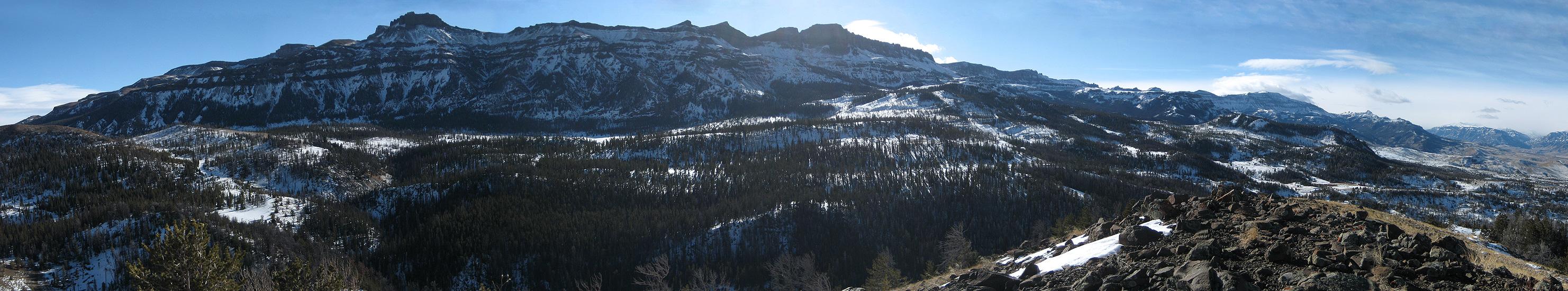
 On the southwest ridge
When viewed from most angles, the small peak known as Peak 8780 is invisible because of the rugged north face of East Carter Mountain. This towering mass rises up to an elevation of over 11,000 feet and is located just a couple of miles south of Peak 8780; it is only when viewed up close that this out-of-sight mountain shows its prominence. The Absaroka Range is known for its thick populations of wolves and grizzlies, and while this peak is relatively accessible in comparison with many of the summits in the range, it does not diminish the likelihood of seeing or encountering one of these animals. During the few hours I spent on the mountain, I saw more wolf tracks than I have ever seen before, and it was quite a rush to see tangible evidence of such a large animal right in front of me!
Very few trips to summits in this area can be completed in half of a day, which is why this peak would be a good option for someone who wants to experience the feel and sights of the Absarokas without going all in. This peak offers a fun mix of hiking and scrambling through widely varied types of terrain, all within the distance of a mile. The steep descent into the drainage at the base of the mountain and the subsequent stream crossing are perhaps accomplished most easily in the winter, when the snow makes climbing in and out less strenuous. Several parts of the west ridge are very steep, and some fun Class 3 climbing can be done in several places about halfway up the ridge. The summit views from this peak are amazing; in addition to the closeup views of Carter Mountain, the South Fork Valley is a great sight beneath Wapiti Ridge, which is the highest peak in the SW Absarokas. The giants of the North Absarokas are on display as well, with Robbers Roost, Mount Dewey, and Trout and Dead Indian Peaks visible in a line across the Buffalo Bill Reservoir.
  |
Getting There and Climbing Information
 An interesting rock formation on Peak 8780; enlarge to see more detail
 Fun scrambling
To get to this mountain from Cody, Wyoming, turn south 0.4 miles west of the traffic light in front of Wal-Mart onto the South Fork Road (291). Drive for about 18.8 miles and turn left onto the Carter Mountain Access Road, which crosses private land for 7.0 miles before entering the Shoshone National Forest. The road is closed at this point from the first heavy snows until May; during the summer months it would be possible to drive the road for another few miles before turning left onto a forest service road which leads closer to the eastern slopes of the peak. A climb from this side would entail a steep scramble of almost 400 feet and would avoid crossing the gully that is encountered when approaching the mountain from the southwest.
 Looking across the South Fork Valley to Wapiti Ridge
 Carter Mountain
 Approaching the summit
The southwest ridge (which is the only option during the winter) is reached by parking near the gate and walking up the road for about a hundred feet before dropping off to the left. There is a faint abandoned road that you can follow for a while; you will want to keep to the right for a while in order to avoid the water in the bottom of the drainage. Once you are parallel to a point near the base of the southwest ridge, drop into the deep gully and cross Bull Creek (about 5 or 6 feet wide) to reach the steep slopes on the other side. During the winter, I found a narrow spot that was frozen over that enabled me to easily get across, but I could hear some vigorous water cascading along beneath the ice; my guess is that you will get your feet wet if you do this route in the summer unless you can find a log or are a good jumper.
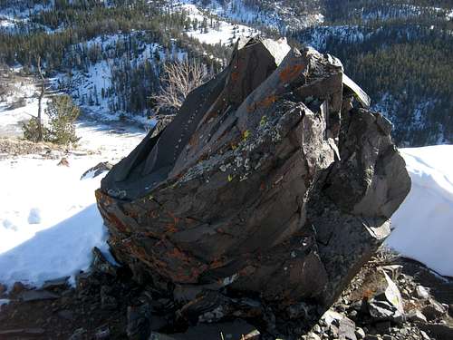 Volcanic summit rock
Reaching the top of the ridge is a very steep scramble, but the footing is good and the scree is negligible. Head towards the rock band and cross it with some Class 2+/3 climbing, which brings you to the gentler slopes that lead up to the summit. The short summit ridge has a couple of small rocky outcrops, and there is an interesting volcanic rock that might be the highest point, but my guess is that the highest point is closest to the SW end. The hiking distance to the top is 1.0 mile with 800 feet of elevation gain from the creek crossing.
 Breccia tower
Red Tape and Camping
There are no permits or fees required to use this area. The Forest road is closed about a mile west of the mountain during the winter months, and it reopens in May. Visit the Shoshone National Forest site for information on camping.In spite of the shortness of this hike, this peak is located on the edge of some very wild country and running into wildlife is a very real possibility. Wolves, grizzlies, and mountain lions are found here, and be prepared to meet any of them in any season; carry bear spray!
 Wolf track on a log near Bull Creek (about 4 inches across)