
-
 29732 Hits
-
 93.1% Score
-
 41 Votes
|
|
Mountain/Rock |
|---|---|
|
|
44.55370°N / 109.2638°W |
|
|
Park |
|
|
Hiking, Mountaineering, Trad Climbing, Sport Climbing, Toprope, Bouldering, Scrambling |
|
|
Spring, Summer, Fall, Winter |
|
|
9116 ft / 2779 m |
|
|
Overview
 Rattlesnake Mountain
Anyone visiting the town of Cody, Wyoming will take notice of the two large mountains that are situated just west of town; the smaller of the two, Cedar Mountain, ranks 17th on the Wyoming prominence list and rises over 2700 feet above the Shoshone River, which runs through the beautiful canyon which separates the two peaks. Rattlesnake Mountain, which is a massive peak measuring about twelve miles in length and three to four miles in width, sits on the north side of Shoshone Canyon and runs along the eastern border of the North Absarokas. While it is 1200 feet higher than Cedar Mountain, it does not have as much prominence because of a relatively high saddle on the north end of the mountain that connects it to Pat O'Hara Mountain. As a result, it comes in at #162 on the Wyoming List with 1,176 feet of prominence.
When viewed from Cody, Rattlesnake Mountain appears as a very long (and very high) ridge that is covered in thick forests. It is very difficult to discern which of the small bumps along the ridge is the highest point from town, but if you travel through the canyon and look at the west side of the mountain from a vantage point near Buffalo Bill Reservoir, the summit is more obvious. At 9,116 feet, the summit is the only point on the long and flat mountaintop that is over 9,000 feet. There are two other points along Rattlesnake's ridge that are prominent enough to qualify as separate ranked summits; Peak 8365 is found to the north near the saddle to Pat O'Hara, and the Guzzler Benchmark (8998 feet) is about a mile and a half SE of the highest point.
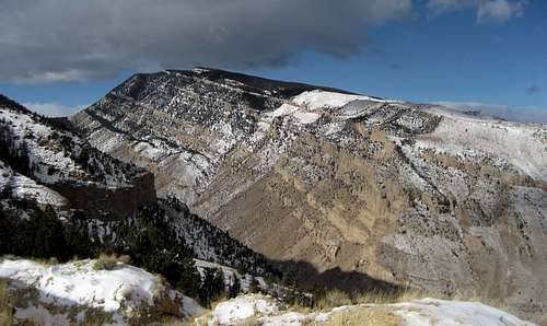
One of Rattlesnake Mountain's most spectacular features is the south face of the peak, which rises over 3300 feet above the river in the canyon in just one mile; this steep face is dissected at several different elevations by rock bands that run horizontally across most of the mountain. The route up this face is a challenging mix of Class 3 and 4 scrambling, dense bushwhacking, and slippery scree slopes.

An interesting feature called the Palisades is found on the NW part of Rattlesnake Mountain. This amazing row of nearly vertical rock formations, some of which are nearly 1,000 feet high, runs in an almost perfect line along the western side of the peak. There is good rock climbing to be had here, and some exploring of routes has been done by a very few locals, but the area is essentially closed to the public due to private land ownership in Rattlesnake Canyon, which runs the entire length of the western side of the peak. See the Access Issues section below for more information on the Palisades.
 The Palisades
Note: I have not yet reached the highest point of Rattlesnake Mountain; while it is generally considered bad form for authors to post SP pages for a peak that they haven't summited, I will justify writing this page for the following reasons:
1. I have climbed the complete south face of the mountain (3300 feet) to the top of the summit ridge. The remaining 500 feet of elevation gain happens over a span of over 3.5 miles, which is a simple walk given that the top is long and flat and there is a road for most of the way; the only thing that prevented me from finishing the climb was a shortage of remaining daylight hours.
2. I have also explored the hiking route on the SE part of the mountain leading to a 4WD road that gains the summit ridge; I was prevented from going to the top by waist-deep snow.
3. I have driven the road to the northern saddle and have researched the access issues regarding the northern approach.
 View from Rattlesnake towards Carter Mountain
 Rattlesnake Mountain
Monument Hill Route
 Rattlesnake Mountain from the north
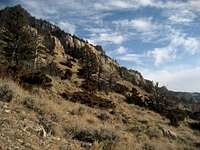
The easiest way to reach the summit of Rattlesnake Mountain is to approach from the north saddle via a road easement through the Trail Creek Ranch. Take Highway 120 north out of Cody, Wyoming for about 8.0 miles and turn left on County Road 7UH, which is also known as Monument Hill Road. A forbidding sign warns drivers to "Travel at your own risk," but the road is in good shape for about 11 miles. At the point where the road almost reaches the saddle between Rattlesnake Mountain to the left and Pat O'Hara Mountain to the right, there is an intersection of sorts with an closed and gated road continuing straight (obviously unused for a long time), a gated road going left, and an open road (Red Grade Road) between them. Here there no less than seven or eight convoluted and misleading signs that attempt to explain the roads, including one at the front that states that travel beyond this point is allowed only with a wood-cutting permit and that there is no public land access. This sign applies only to the road that heads left up onto Rattlesnake, so unless you have a permit to gather firewood, park here and continue through the gate on foot.
 Signs at the gate
 Looking west from Rattlesnake to Robbers Roost Peak
Make sure to have a map for this hike, as the numerous forested bumps off to either side are difficult to tell apart, and there are lots of smaller roads that branch off in various places. Walk the road for about 6.5 miles and head to the right once the summit is nearby, and head up for about 400 vertical feet to the only point that rises above the 9000-foot contour on the map. While the topo map shows the summit to be covered in trees, satellite images show evidence of heavy logging around the highpoint, so while a complete panorama may not be possible, the views are still going to be amazing. To reach the Guzzler Benchmark, continue along the road for another 1.5 miles and head slightly right to the summit.
A one-way trip to the top of Rattlesnake Mountain via the Monument Hill Road is 7.0 miles with 1100 feet of elevation gain on Class 1 terrain.
Southeast Slopes Route
 SE slopes view towards Red Butte
This route is best for the casual hiker who wants to get out, do a lot of hiking in a super-long day (or two), get in some serious elevation gain, and experience just how big Rattlesnake Mountain is. To start this hike, travel a little ways into Shoshone Canyon and look for the small green sign that points to the Bureau of Reclamation office. Turn right on this road, which drops and crosses a bridge. Park after the bridge before the gate and hike up the hill on a small trail to join the road that heads back to the east on the north side of the river. After rounding the SE corner of the mountain, cross through the gate and scramble to the left and up over the place where the canal enters the underground tunnel; in times when the canal is empty, it is also possible to follow the right side to the place where the canal changes from concrete to dirt and cross over it there. The map marks a footbridge around this area, and while I did not find it during my hike, it may be farther north along the canal.
 4WD road on Rattlesnake Mountain
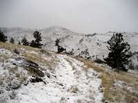
 Nearing the top of the ridge in deep snow
From here follow the west side of the canal until you see the abandoned 4WD road that starts ascending the mountainside. Follow this road for 2.5 miles and 2000 vertical feet to the meadows below the forest. Keep to the right of the trees and enter them below the isolated white spot on the map to join another 4WD road that ascends this gully all of the way to the top. This clearing on the map is a steep hillside that covered in boulders, and it is best to avoid crossing it if possible, especially if they are covered in snow. Hike the steep road for 1.5 miles and 1500 more vertical feet to the summit ridge and continue past the Guzzler Benchmark to the summit.
The total one-way distance for the Southeast Slopes route on Rattlesnake Mountain is 11.0 miles and 4100 feet of elevation gain on Class I terrain. Most people will require two days to complete this hike.
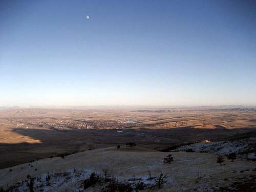 The moon over Cody at sunset
Note: It is also possible to drive Country Road 2ABW from the Belfry Highway to approach the base of this route; depending on where the road is closed to public traffic, this may cut one or two miles off of the hike.
South Face Route
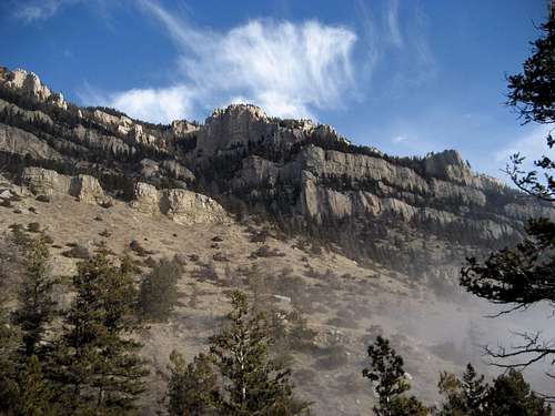 South face cliffs
The most exciting (and by far the most difficult) route on this peak is a direct assault on the south face of the mountain, where you will encounter a wide variety of challenges on very steep terrain. While it is mostly a scramble, I would recommend taking a helmet to guard against the danger of rockfall from above and to protect your head from the numerous and persistent tree branches that will be in your way; I whacked my head fairly solidly at least five or six times on trees and rocks during the bushwhacks and more exposed scrambling parts. An axe or hiking poles are also very useful on this climb. This climb is very steep, gaining over 3300 feet in just under 1.5 miles.
Travel towards Shoshone Canyon from the west end of Cody and pull off and park on the expanded shoulder area just before entering the first tunnel. Walk through two tunnels along the highway before reaching the popular rock climbing area that is located to the right before the long tunnel. The rock prow in the middle of the area is called the "Nose"; start the climb on the right side of this formation by hiking up the very steep trail that goes up and over the saddle down into a narrow canyon that is flanked by steep rock walls. Bushwhack through the underbrush, thorns, and trees in this canyon until you hit a headwall near the end that is no longer rock. There is no trail through this area, but generally the left side going up offers less resistance from vegetation.
 Steep Terrain
 Scree Gully
After gaining the top of the head wall, head generally left towards the forested area below the cliff bands that loom above you, making for the obvious gully that is visible on the far left side of the face. Once you are near the bottom of the gully, continue up the very steep slopes around the rock formations that you will find in your way every couple of hundred vertical feet. Sometimes it is easier to climb them than to go around them; on my trip here, my partner and I climbed an easy Class 3 gully and later a ten-foot chimney that we rated at about 5.3 or 5.4 to avoid some of the nastier scree slopes. Use care on some of these loose slopes, as this is not an easy place to get out of if you sprain an ankle or worse! We ascended mostly to the east of the gully to avoid deadfall, but we descended on a route farther to the west that was directly in the bottom of the drainage. Be prepared to do some scrambling and route-finding in the event that you reach a place that cliffs out on the descent.
 Heart Mountain
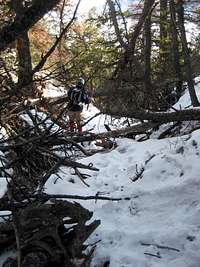 Bushwhacking
Once on top of the ridge, walk NW through the fairly sparse forests to join the 4WD road described in the SE slopes route. Continue on this road for almost 4.0 miles miles up and over the Guzzler Benchmark to the summit. A one-way trip to the top of Rattlesnake Mountain via the South Face Route is just under 6.0 miles miles with 3900 feet of elevation gain on terrain that never has to be harder than Class 3 with good route-finding, but can easily be Class 5 if you want something more exciting. While this is the shortest route on the mountain, allow at least four hours to complete the face climb to the ridge top.
 Easy class 5 chimney
Access Issues
 Monument Hill route
 Southeast slopes route
 South face route
The large area on top of Rattlesnake Mountain is part of the Shoshone National Forest; there are a few very small plots of private land along the wide ridge, but the vast majority of it is public land. Trail Creek Ranch is located on the eastern slopes, and the owners of this large property have been involved in prolonged legal battles with the Forest Service for several decades regarding easements and access to these public lands via Monument Hill Road. As it now stands, vehicle travel ends at the gated area at the end of the road unless you have a woodcutting permit and are there for the purpose of gathering firewood. As described on the Trout Peak page, there is a road from this point that accesses the Spout Springs area and the Nation Forest on the side of Pat O'Hara Mountain, but this road does not lead any closer to Rattlesnake Mountain. Part of the problem with vehicle access to Rattlesnake stems from years of abuse by irresponsible ATV owners who destroyed large areas on either side of the road, resulting in wide, ugly swaths running up and down the green hills. During the winter, Monument Hill Road is closed to prevent the road from becoming completely torn up; a recent article in the Cody Enterprise discussed this, and the vehemence of some of the comments by readers is telling of what a touchy issue this whole area is among local residents.
The lower west side of the mountain is under control of the Mooncrest Ranch, which is owned by New York businessman Robert Model, a great-grandson of Standard Oil co-founder William Rockefeller. His son Bobby Model was a well-known photographer for the National Geographic Magazine as well as a world-class climber; he explored some routes on the Rattlesnake Palisades before a freak accident in Africa in 2007 that caused severe brain damage. He survived for two years after the accident, but he died in September of 2009 in Cody. His most famous climb was a free ascent of the East Face of the Nameless Tower in the Karakoram Range. The Mooncrest Ranch closes off all public access to Rattlesnake Canyon and easy access to the Palisades, which are located on public land. Trespassing around here is not taken lightly; a friend who reads meters for the power company was chased down and questioned by an individual with a gun during a routine visit to a ranch in this area. He happened to be driving a personal vehicle that day because for some reason a company truck wasn't available, so he was asked to provide identification and was cleared after a phone call to the office to verify that he was supposed to be out there.
The three routes described on this page avoid any trespassing problems; however, they are all long trips unless you buy the woodcutting permit, which would enable you to drive farther south along the top of the mountain. Getting to the Palisades is possible from the end of Monument Hill Road, but reaching the base of the formations would require a hike of about 3.0 miles across the plateau on top and a bushwhack and steep descent of about 1200-1500 feet.
Red Tape and Camping
 Looking across the canyon to Cedar Mountain
Before visiting this mountain, it would be a good idea to visit the Cody BLM office and study the large property ownership map that hangs on the wall; the only permit required would be if you want to drive past the gate on Monument Hill Road.
Visit the Shoshone National Forest website for information on camping; many people will want to take two days to hike on this mountain, so make sure you know the rules for food storage in grizzly country.
Wildlife is abundant on Rattlesnake Mountain; grizzlies and black bears are found here, and mountain lions are found here as well. The mountain is named for a reason: Never stop looking for snakes if you are hiking here in warm weather, as this area is prime habitat for rattlers.
External Links
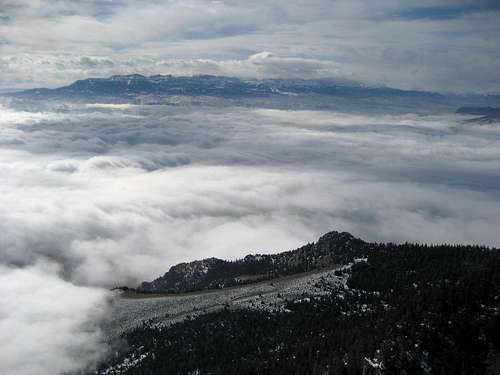
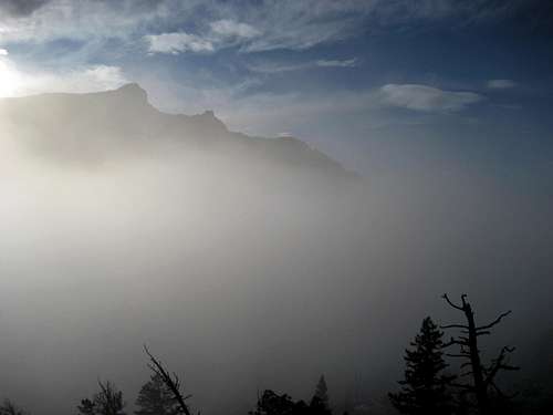
 A river of clouds
Bouldering on Cedar and Rattlesnake Mountains
Pictures from Rattlesnake Mountain
Bobby Model's site
Bobby Model's obituary