
|
|
Mountain/Rock |
|---|---|
|
|
43.41696°N / 113.53898°W |
|
|
Butte |
|
|
Hiking |
|
|
Spring, Fall, Winter |
|
|
6515 ft / 1986 m |
|
|
Overview
Big Cinder Butte is the highest volcanic feature in Craters of the Moon National Monument at 6515 ft. The only other higher point is an unnamed non-volcanic point in the Pioneer foothills to the north. The peak is very visible from the highway between the monument visitors center and Carey, ID but is not that easy to get to, especially in the winter. It lies just inside the Craters of the Moon Wilderness Area and the terrain around it, like all the terrain in Craters, is pretty nasty.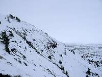 The Western Side
 From Broken Top
The eastern side is steep as well but is mostly covered with the limber pines that frequent the area. There seems to have been a fire here as
 The Eastern Side
Several lava flows surround the butte. On the West are the Blue Dragon and Crystal Fissure Flows. The South is home to the Derelict Flow. The Buffalo Caves Flow surround Big Cinder Butte on the North and East sides. The southeastern slopes go down to a complex area called Trench Mortar Flat which is home to many cracks and craters.
This is a very interesting area with many possibilities for exploration but it can be quite inhospitable during the summer months. Distance wise it is not far from a road but it is still a semi difficult peak to access due to the horrific lava terrain surrounding it. Climbing it in the winter is a fun challenge that can make the peak both more difficult and easier in some ways. It is harder to get to in the winter but being on snow prevents you from having to deal with the sharp rocks buried under the snow. The snow also presents other challenges though.
The peak can be climbed by itself or in conjunction with other nearby features such as Broken Top and Half Cone.
Getting There
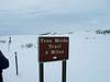 The sign
Once inside the monument there is a long vehicle loop that takes visitors around most of the easily accessed features. At the southern end of the loop there is another road leading to the Tree Molds Trailhead. (There is a sign.)Follow this road to its end. Here you will see Big Cinder Butte rising directly South of you across a lava field. Follow the Tree Molds Trail South for a ways but break off and follow the tree covered ridge that head up the northwest side of the butte. This will give you access to the summit.
 Map
MapRed Tape
There is an $8 fee per vehicle to enter the park. The fee is $4 if you come in on foot, bike, or motorcycle. If you plan to stay overnight the fee is $10. In the off-season the price is reduced to $6 and during the winter there is no fee. To enter the backcountry, where Big Cinder Butte is located, you will need to obtain a free backcountry permit at the visitors center.As with everything in Craters, be aware that not only is this desert, it is a vast blackened lava field which can cause surface temperatures to soar in the summer. It can easily reach 100 degrees or more and the effect of the lava can raise the temperature further. This is why I would only recommend this hike for spring, fall, or winter when conditions in the park can be quite nice.
 A Crater
The winter poses its own set of difficulties. This area can be quite cold and windy and it can receive a decent amount of snow each winter. This is not unlike most mountainous areas but the snow cover makes navigating some of the lava fields treacherous. You can't see many of the holes and cracks like you can when there's no snow, but it also makes travel easier in rough, rocky areas where the loose volcanic ash is covered up. As a general rule the trees tend to grow in areas that are a little more tame (this DOESN'T mean they don't grow in nasty places too) so if you stick to them you shouldn't have too many problems for the most part. Climbing here in the winter also lengthens the approach from about a mile to a 12 mile round trip. The good part is that most of this distance is on a flat, groomed road. Very few people visit the area near Big Cinder Butte in the winter and this makes it even more appealing. You're almost guaranteed to have the butte all to yourself.
The biggest thing to remember here is BRING YOUR OWN WATER. There is NOWHERE to get it other than in the campgrounds.
Camping
As mentioned before there is a $10 fee to stay in the campground near the visitors center. Backcountry camping is permitted and there is a $12 fee for a permit to do this. There is very little terrain around Big Cinder Butte that would be conducive to camping but I'm sure there are some interesting spots to be found.