|
|
Mountain/Rock |
|---|---|
|
|
40.17680°N / 111.5241°W |
|
|
Utah |
|
|
Hiking |
|
|
Spring, Summer, Fall |
|
|
7990 ft / 2435 m |
|
|
Overview
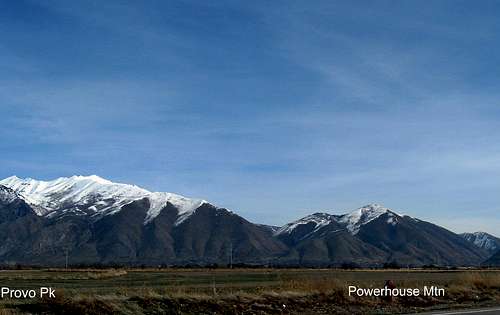
Located just east of Springville Utah is Powerhouse Mountain. With its 1250 feet of prominence, Powerhouse Mountain is of interest to that group of folks that love to chase the prominence peaks that have over 1000 feet of prominence. Powerhouse Mountain isn't well known and so hopefully this page will make others aware of its existence. When traveling north on I-15 just after passing the Spanish Fork exits, you would have to know where to look to be able to spot this mountain. Most people would be looking up at Provo Peak or Buckley Mountain if they did glance that direction and Powerhouse is found to the right of both of those.Utah county is loaded with mountains and Powerhouse mountain is one of thirty peaks that have more than one thousand feet of prominence. Now the state of Utah has 360 peaks that have more than one thousand feet of prominence and Powerhouse Mountain comes in at #212 on that list. I will give credit to SP member Eric Willhite for bringing this one to my attention after he
posted a page about it on his website. My son and I were looking for something to do and this one looked interesting to us and didn't require a long drive to deal with. So on a rare day when my son had a day off, we teamed up to see what this little mountain was all about.
SP member Tracy shared this about the probable origin of the name of "Powerhouse Mountain":
it is my opinion that the name came from the close proximity of hydraulic generators or "power houses" that have existed at the base of the mountain - both in Hobble Creek and at the mouth of Bartholomew Canyon. One was built in 1948 and expanded in 1987. The other power house was built in 1950"
Recently a fire affected the south side slopes of Powerhouse Mountain but I'm not sure if it affected the summit area at all.
 ATV track
 |  Meadow
 |  On ridgeline
 |
Getting There
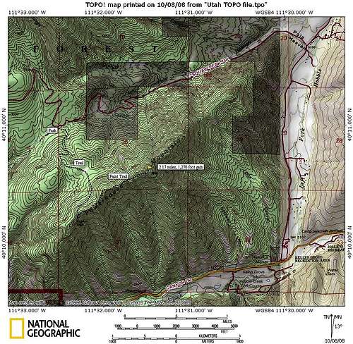
Find your way to Hobble Creek Canyon by taking the Springville/Mapleton (exit 260) off I-15. Drive east on 400 South through Springville. When you hit a fork, turn right onto a road that becomes Hobble Creek Canyon Road. Several miles into the canyon, passing the Hobble Creek golf course along the way, the road will reach another fork, take the left that heads north. The road you need is found off of this road (see map) find a wide but poorly signed dirt road to the left. This is the Squaw Peak Road. Follow this rough road 1.2 miles to a gate. Early in the season, this gate will most likely be closed. If so, you can park at the gate and hike two miles up the road to what will normally be the "summer" trailhead. The road leading to the gate is signed on both sides by many "no trespassing" signs. Be sure to keep to the road.If the gate is open, then you can drive the two miles but be aware you will need high clearence. The road gets really rough and we saw a disabled passenger car the day we visited this mountain that tried to go up the road but did not have adequate clearence. The trailhead (not marked) is found just off the Squaw Peak road (GPS 40.1825 111.5403 nad 27 elev 6760') (See map)

|  Almost there
 | 
|
Route information
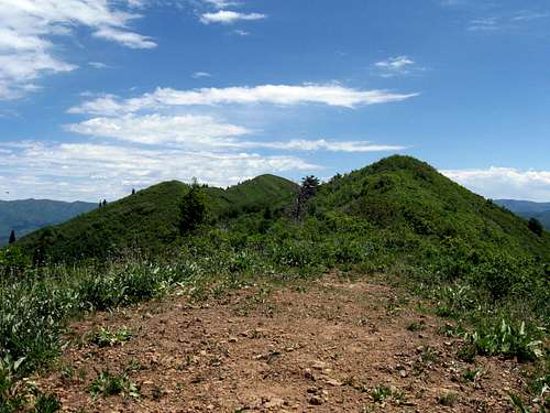
From the "summer" trailhead, it is a two mile hike to the summit with 1300' of elevation gain.The route starts out as a road going steeply up into the forest. Quickly, the road becomes more of an ATV route. After 500 feet of climbing, the ATV road then drops a bit into a nice meadow area, after which the road then starts a 400 foot climb to the ridgeline and views. At the ridge line, now out of the trees, take a left and continue on the ATV trail until it ends just up the ridgeline. A trail then continues on its way up the ridgeline but in a few places, it becomes possible to lose it in the brush. If you stay close to the ridgeline, you will most likely be able to find the trail again but in places you might encounter a bit of brush bashing.This rough trail will take you all the way to the summit where you will find a cairn and hopefully, a register that I placed (look for a red topped plastic container).
If you have to hike up from the gate, add an additional 4 miles to your roundtrip effort which would make it 8 miles in all.
Zeejay indicates that she came up from the south side. I've included here what she had put in the climbers log.
"Started from Canyon Drive almost directly south of the peak and went up the south ridge. It was 3000 vertical feet in 1.33 miles. Except for the last little bit the ridge was either wide open or there were some overgrown trails through short sections of brush. The last 20th of a mile to the top was pretty dense. On the way down I skirted it to the west."
Lists of John indicates that 8 people have done this one but the actual number is higher since my son did it with me and Eric Willhite's two children made it as well. Also, Tracy had a couple more with him and there are several that signed onto this page's climbers log so this one does get to see some human footprints from time to time.
Red Tape
The Squaw Peak road passes through private property during the first mile till it reaches the gate but beyond the gate, you will enter Uinta National forest. For more information on the gate situation and the road condition, contact the ranger station that is located in Spanish Fork Utah:Spanish Fork Ranger Station
44 West 400 North
Spanish Fork, UT 84660-1414
(801) 798-3571

| 
| 
|
Camping
A national forest service campground is located near Mapleton Utah (near Springville). It is the Whiting Campground and more information and directions can be found HERE.Since this is mainly an easy day hike, only out of town visitors would need either a campground or a local motel (many in Provo).
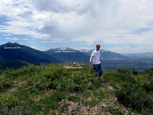
 View North
 |  Summit cairn
 |  View east
 |
Weather
 Summit view south