
-
 23399 Hits
-
 85.87% Score
-
 21 Votes
|
|
Mountain/Rock |
|---|---|
|
|
39.39450°N / 106.0221°W |
|
|
Summit |
|
|
Hiking |
|
|
Spring, Summer, Fall, Winter |
|
|
13229 ft / 4032 m |
|
|
Overview
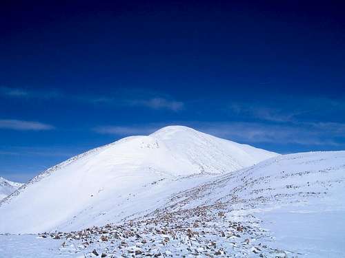
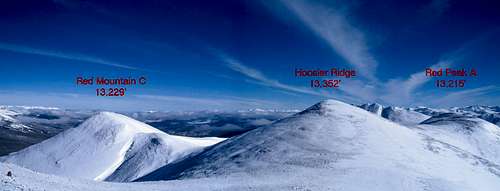
Red Mountain (C) is the third highest peak named Red Mountain in the State of Colorado, at an elevation of 13,229' it is also the 456th highest peak overall in the state. The peak resides approximately 3/4 mile to the northwest of the Continental Divide near the high point of Hoosier Ridge and rises 369' from the connection saddle. Though often climbed with its higher neighbor, the peak can also provide a worthy outing on its own, generally accessed from the small community of Blue River to the north. Unlike its nearby neighbor, this peak resides entirely within Summit County.The true wonder of Red Mountain (C) is its perch for taking pictures of the Tenmile Range to the west. The summit perhaps offers the best view of Quandary Peak from any high peak, as they lie directly across the valley from each other.
The peak gets its name from the red soils on its northwestern flanks, easily visible when driving south along Colorado State Highway 9 south of Breckenridge. It is also the farthest west 13er in the Front Range.
Getting There
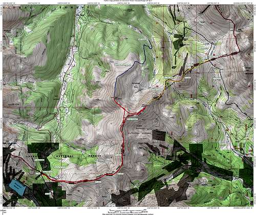
The peak can be accessed in numerous ways, however, the western side is mainly private land.Access from the North is through the town of Blue River via Pennsylvania Creek, and looks simpler on the map than it actually is, Sarah Simon provides excellent directions on her page for Mount Argentine's standard route. Turn east off of Colorado 9 on Blue River Drive, then turn east on Royal Drive, left on Regal Circle, and left on Coronet Drive. Just after a sharp hairpin to the left is a wooden forest service sign that serves as the 2WD trailhead. You can continue up this road in 4WD, but it is narrow and rocky and a bit difficult to pass other vehicles. Watch out for mountain bikers as well!

From the south/south west of the peak, access is from Hoosier Pass located on Colorado 9 approximately 11 miles south of Breckenridge and 5 miles north of Alma. The pass is at 11,539' above sea level, and is a popular place for those driving through to make a quick stop for a picture. There is a fairly large parking area to the west of the pass, and it serves as the trailhead for North Star Mountain as well. The trailhead is maintained in winter, however there are portions on the north side with an 8% grade and can be a rough drive in heavy snow.
From the east, Boreas Pass, at 11,482' and is located 9 1/2 miles south east of Breckenridge provides access. To get here follow the Boreas Pass Road (initially paved) west from the traffic light just south of Breckenridge. The road turns to dirt, but is well graded and usually passable by most vehicles when dry. Boreas Pass is named after the Greek God of the North Wind and once was home to the highest Post Office in the US. More information about the history of the pass can be found on the page for Boreas Mountain.
Red Tape
The west side of the peak has a lot of private residences, but the peak is easily accessed from all other directions on public lands.Red Mountain C is included in the Hidden Gems Wilderness campaign, if passed by Congress the summit area as well as including Hoosier Ridge would be part of a new wilderness area to be designated "Hoosier Ridge Wilderness". For more information, click here.
Camping
Pennsylvania Creek provides some options for dispersed camping, be sure to check the message board at the 2WD trailhead to see if there are any regulations in the area.In winter the Boreas Pass side offers two Mountain Huts, the Section House and Ken's Cabin. Reservations can be made at the 10th Mountain Division Hut Association's webpage: Huts.Org
Route Information
If climbing with Hoosier Ridge, the most popular way to ascend this peak and its neighbors would be the "Three Pointer": Class 2, 11 1/4 Miles RT, appx 3000' elevation (incl. false summits) RT.

You can also access this peak from the north or northeast by traveling along Pennsylvania Creek. A route directly up the north side would involve a lot of bushwhacking off trail through the pine forest. Good navigation skills would be a must! Slightly easier to navigate, but longer without 4WD, would be to continue up the Pennsylvania Creek road to its end near Horseshoe Basin. I have never driven or hiked this far up that road, so do not know exactly how difficult of a drive it would be, but expect it to be at least as primitive as the lower road, which was very rocky and narrow.
Special Considerations/ Gear
Weather is always a factor when planning a trip to Colorado's High Country, the below link should give you an idea of what to expect for your trip: NOAA Forecast. Lighting is a big concern in summer, and much of the ridge is exposed above treeline.You may also want to consult the local Ranger Station to find out any current information. Their offices are located in Fairplay and can be reached by phone at (719) 836-2031.
No special equipment is needed under normal conditions. In winter access via Hoosier Ridge would be the most sensible. Snowshoes or skis will be necessary below treeline and maybe above depending on how wind swept the ridge is. There is a cornice that forms on the south ridge of Red Mountain (C) and care should be taken when traversing between it and Hoosier Ridge in high avy danger. Avalanche forecasts are available here: CAIC Forecast for Summit County
Wind can be a concern and high winds are very common in the area. SP member Scott Patterson posted a trip report about a dangerous experience he had with high winds on a neighboring peak: Dangerous Winds
Annotated Map of the Area
Overview of the Area - Click to enlarge