
-
 8965 Hits
-
 95.01% Score
-
 50 Votes
|
|
Mountain/Rock |
|---|---|
|
|
36.60476°N / 118.12771°W |
|
|
Sport Climbing |
|
|
Spring, Summer, Fall, Winter |
|
|
4667 ft / 1423 m |
|
|
Overview
 East end of Cattle Pocket area
 Cattle Pocket area
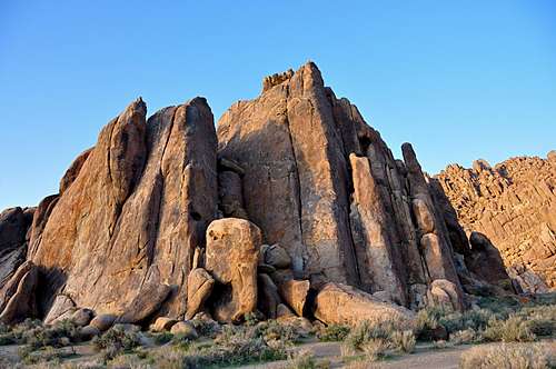
 Blackhawk Pinnacle
Cattle Pocket is an area containing several rock formations in the Alabama Hills in the outskirts of Mount Whitney in the Sierra Nevada Range, California.
You may have seen countless old black and white movies with cowboys on horse backs riding amongst rounded rock formations with majestic views of Mount Whitney in the background. These rock formations are in a vast area known as Alabama Hills. Cattle Pocket is where the movie companies corralled their horses and cattle between scenes.
Cattle Pocket itself is a broad flat area surrounded by rock formations with only a couple of escape routes, if you are of the four-legged variety, of course. Nowadays, however, there are no signs of horses and cattles anywhere near the area. The rock formations known as Cattle Pocket were named after the general area, although they are located a few hundred feet before reaching the actual pocket itself.
Looking from across the wash, Cattle Pocket resembles individual towers leaning to the right and about to fall over. Not to worry, they are not going to. In fact, there are a number of classic routes on these formations. As you approach the main body of the formation, you pass by a prominent pinnacle. This is Blackhawk Pinnacle and it’s not connected to the rest of Cattle Pocket formations. There is one climb on this formation called, Blackhawk Pinnacle, rated 10b. This route is terribly grainy and may not be the most enjoyable route in this area. If you are short like me, you will have a terrible time reaching the anchor after clipping the last bolt.
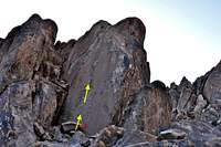 Extreme right side
The next truly enjoyable climb is called Fizz, rated 10b, and located on the next leaning tower to the right of Choos, Moss. This route may have been grainy at first, but when I climbed it in 2006, it was pretty well cleaned up. The crux of the climb is between the fifth and the sixth bolts. After reaching the anchor, you may want to consider top roping a route just to the left of Fizz. This route is called Pop, rated 11a.
The ugliest and least enjoyable route on the entire formation is on the arete across from Fizz. This route is called (Split), rated 5.8. You don’t want to take a fall on Split; you may hit the rock with Fizz on it. Another enjoyable and moderate route in the Cattle Pocket area is Magic Pig, 5.8. Although this route has a funky start, it soon turns into a great climb.
How to Get to Cattle Pocket:
From the town of Lone Pine, California, on Highway 395 take Whitney Portal Road at the only traffic light in town. Drive 2.7 miles west on this road to intersect Move Road. Turn right onto the Movie Road. This road is paved for a short distance then it turns into a dirt road. The first dirt road to intersect the Movie Road heads for Shark's Fin. Miss this one and drive about half a mile to the next dirt road from the left. Turn into this one and pass by Paul's Paradise. Shortly further up the road you will see the Blackhawk Pinnacle. The entrance into Cattle Pocket area is about a hundred feet beyond this point. Park in one of the dirt pull-outs making sure not to block the road for other visitors.
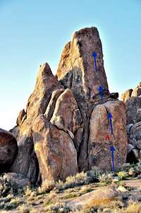
List of Select routes of Cattle Pocket
Select Routes of Cattle Pocket area | |
| A | Blackhawk Pinnacle, 10b, bolts, anchor |
| B | Choss, Moss and Butt Floss, 10a, bolts, anchor |
| C | Pop, 11a, bolts, share anchor with Fizz |
| D | Fizz, 10b, bolts, share anchor with Pop |
| E | Magic Pig, 5.8, bolts, anchor |
| F | Slab Route, 10a, bolts, this climb is on the smooth face on the extreme right side of Cattle Pocket |
Select routes of Cattle Pocket
 Blackhawk Pinnacle, 10b Blackhawk Pinnacle, 10b |  Cattle Pocket, middle section Cattle Pocket, middle section |  Magic Pig, 5.8 Magic Pig, 5.8 |
Camping
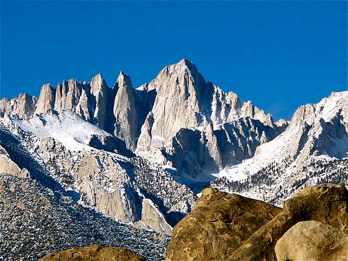 Mount Whitney
If you don't mind driving another fifty miles, there are many campgrounds along Bishop Creek just to the west of Bishop. There are also many places in The Buttermilks area that are close to a creek that are suitable for camping. Please do not camp in The Buttermilks bouldering area. That area is very crowded and is suffering from the impact unregulated camping has caused.
The following links should help finding a good campsite
Horton Creek Campground
Rock Creek Canyon
Inyo National Forest
Bishop Creek and vicinity camping