
|
|
Mountain/Rock |
|---|---|
|
|
42.73000°N / 19.29128°E |
|
|
7018 ft / 2139 m |
|
|
The highest peak of Maganik range
  |
The massif of MAGANIK stretches in east-west/northwest direction. That beautiful and impressive range with its unique outlook is separated from Moracke Planine on the north and from Prekornica mountain on the south. Maganik is known as a little beat unapproachable mountain range. Maganik is an aloof group of impressive limestone formations. The geological composition of Maganik is made of cretaceous bank limestone. The base of this mountain range from the Niksic side and the Moraca River valley is made up of Triassic limestone.
The highest peak of that for sure the wildest mountain range of Montenegro is Međeđi Vrh (2139 m)(Bear's Peak). Međeđi Vrh is placed in the central part of Maganik. On its eastern side Međeđi Vrh stay above the wild Mrtvica Canyon which is cutted deep below the Mrtvičke Grede cliffs, where the Mrtvica River flows. Međeđi Vrh is placed on the S from Kapa Moračka (2226 m), Babini Zubovi (2111 m) and Stožac (2141 m), on the SW from Trešteni Vrh (1980 m), n the E from Kokotov Vrh (2001 m), on the S-SW from Babji Zub (2277 m, Sinjajevina), on the W from Prekobrđe (Prekobrdje, Donja Morača-Lower Moraca) and KOMOVI range, and finally on the NE from Prekornica (1927 m) mountain.
On its western side Međeđi Vrh is connected with Kokotov Vrh (2001 m) by the pass, from where going the path to Zabrđe Katun and then to Velje Duboko village. Behind the Kokotov Vrh peak is placed Prijevor Pass (1780 m) which separate Maganik massif on two parts. On the oposite side from Prijevor is Čakmakov Vrh (1974 m) as a connection to the ridge to Petrov Vrh (Kurozeb, 2124 m), and then to the north to Žuta Greda (2104 m) peak and Rogođed (2037 m). Also, on the northern edge of Međeđi Vrh summit you can notice beautiful viewpoint to impressive Babini Zubovi (2111 m)(Grandmother's Teeth).
 |
Summit View
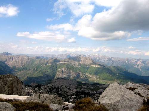 Summit view to Moračke Planine and Sinjajevina
As a highest peak of MAGANIK range, Međedov Vrh (2139 m) offer a good summit view in all direction:
N: Babini Zubovi (2111 m), Stožac (2141 m)
NE: Trešteni Vrh (1980 m)
W: Kokotov Vrh (2001 m)
N-NE: Babji Zub (2277 m, Sinjajevina range)
NW: Žuta Greda (2104 m), Žurim (2035 m), Čakmakov Vrh (1974 m)
E: Prekobrđe (Prekobrdje, Donja Morača-Lower Moraca), KOMOVI range
SE: ŽIJOVO range, PROKLETIJE range
SW: Prekornica (1927 m)
 |
Routes Overview
ROUTE 1Medjurijecje (211 m) - Mrtvo Duboko village (360 m) - Granica village (1042 m) - Poljana katun (1594 m) - Medjedji Vrh peak (2139 m): 6.30h
Note: That approach and ascent is with highest height difference - 1778 m!
Height difference: 1778 m
Lenght: 10,5 km
Duration: 6.30h
Unmarked trail
From Podgorica, there are 33 km on the Adriatic highway to the Pjenavac bridge in the direction of Kolasin. The start of this trail is at that bridge. Turn left and its 5 km of gravel road to the Mrtvo Duboko School. From there follow the steep path through the beech trees towards the southwest village of Granica and the lane that leads to the Poljana katun. This katun is located under the Medjedji Vrh peak. One can also go by wagon trail to the village of Granica, turning onto a road 1 km before the Pjenavac bridge on the Adriatic highway and then go to the village of Trmanja. After a few kilometers, a leg separates and goes to Granica. One can also take shortcuts on foot.
The ascent from the Poljana katun to the top is north towards the Razvrsje Plateu and then goes through a jagged limestone ridge on the eastern slope of the Medjedji Vrh peak, through meadows and rocky ground. For the return and for its beauty, it is recommended to descend northwest through the Strbina Pass. Then go north toward the katuns of Zabrdje (1722 m) and Ogradjenik, to Velje Duboko. From Velje Duboko, along the Mrtvica Canyon, descend to Medjurijecje. This descent goes from Medjedji peak, through the Zabrdje katun farther on to the Mrtvica Canyon. This tour can also be made from Velje Duboko on a gravel road 12 km through Lijesnja and Cerovice down to Medjurijecje. It is also recommended to plan two days, with and overnight stay in the Zabrdje katun.
ROUTE 2
Niksic - Laz - Kutsko Brdo - Stitovo - Rekocica 1512m - Maganik katun (1621 m) - Medjedji Vrh peak (2139 m): 3h
Height difference: 626 m
Lenght: 6,5 km
Duration: 3h
Unmarked trail
For one who chooses this approach to Mt Maganik's Medjedji Vrh peak by all-terrain vehicle from Niksic, take the Niksic-Zupa asphalt road near the village of Laz, turning left onto another asphalt road and then take the gravel road through Oblatno to Kutsko Brdo (bauxite mines). Cross the Sititovo plain to the Rekocica katun (1512 m). The beginning of this trail is at the katun of Rekocica, ascending along a steep goat trail northeastwardly to the old katun of Maganik. The path then goes through a vale to the Strbina pass between the Kokotov (2001 m) and Medjedji Vrh peaks. Right and southeast of the pass via a rocky crest is the ascent to Medjedji Vrh summit (2139 m).
ROUTE 3
Velje Duboko village (840 m) - Prijevor Pass (1780 m) - Kokotov Vrh (2001 m) - Međeđi Vrh (2139 m): 4h
Duration: 4h
Height difference: 1280 m
 |
Getting There

You can choose to approach Međeđi Vrh from three sides - from Niksic via Laz-Kutsko Brdo-Rekocica-Maganicko Polje, from Medjurijecje via Mrtvo Duboko village and from Velje Duboko village.
By plane:
The closest airport is the one in Podgorica (70km away).
If you are planning to come via Serbia, you can use the Belgrade (Beograd) Airport in Beograd (Belgrade) city, capital of Serbia and Montenegro.
Information about flights and tickets on JAT Airways web page.
By train:
Beograd - Kolašin (Bar - Beograd) railway passes through Mojkovac and Kolasin. Then by car or taxi from Kolasin to Međuriječje or Nikšić.
By Bus:
From Beograd (Belgrade):
Beograd (Belgrade) - Cacak - Uzice - Zlatibor - Nova Varos - Prijepolje - Bijelo Polje - Mojkovac - Kolasin
Then by car or taxi from Kolasin to Međuriječje or Nikšić.
From Podgorica:
Podgorica - Međuriječje
Podgorica - Nikšić
For the bus tickets and informations about but lines see Belgrade Bus Station page.
By car:
From Beograd (Belgrade):
Beograd (Belgrade) - Cacak - Uzice - Zlatibor - Nova Varos - Prijepolje - Bijelo Polje - Mojkovac - Kolasin - Međuriječje (or Nikšić)
From Podgorica:
Podgorica - Međuriječje (or Nikšić)
You should drive along the central Montenegrin highway, which connects the seaside to the towns: Cetinje - Podgorica - Kolasin - Mojkovac - Bijelo Polje; and goes on to Serbia (Belgrade city). This road is passable during most part of the year. It is closed only in case of abundant snowing or great rockslides. The landscape along the highway is particularly picturesque in the segment of the Moraca River Canyon between Podgorica and Kolasin. This part of the canyon is called “Platije”. The highway is built along the edge of the narrow canyon. Thus, you can enjoy in observing the beautiful contrast between steep, dark cliffs and light, green river, while round, white peaks of Bjelasica glow in the distance. At moments, this beauty becomes scary!
Camping
If you approaching Međeđi Vrh from Morača Canyon via Međuriječje, the optimal place to stay is Mrtvo Duboko village, placed below the massif of Međeđi Vrh.Also, the massif of Maganik is surrounded by many katuns (lodges) where people living on the mountain only during summer. Known katuns are Rekocica, Maganik, Poljana, Vragodo, Ogradjenik, Zabrdje, Razbijena Jela, Magline, Stanjevica Rupa, Besovica Katun and others, where you can freely use your tent for camping or stay in free shepherd's lodges.