Page Type Page Type: Mountain/Rock
Location Lat/Lon: 38.62850°N / 119.99246°W
Additional Information County: Alpine
Activities Activities: Hiking, Mountaineering
Seasons Season: Spring, Summer, Fall
Additional Information Elevation: 9846 ft / 3001 m
Sign the Climber's Log

Overview

View of the northern face of Deadwood Peak from point 9626.
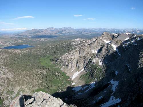
Northeast face of Deadwood Peak above Summit City Canyon
Deadwood Peak lies in the center of Mokelumne Wilderness across Summit City Creek from Round Top. Its isolated position and steep drop-off on its northern aspect give it a magnificent view. A worthwhile side trip out to point 9626 gives a view directly down into Summit City Canyon and of the steep north face of Deadwood Peak.

Getting There

From CA-88 at Hope Valley about 6 1/4 miles east of Carson Pass or 2 1/2 miles west of CA-89, drive Blue Lakes Road about 13 miles to the trailhead at the outlet of Upper Blue Lake. The trailhead is on your left right after the Damsite campground. Blue Lakes Road is closed in the winter and usually opens in late spring or early summer depending on the snowpack.

Route Info

Deadwood Peak route
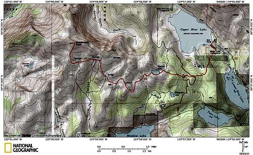
Route from Upper Blue Lake
Granite LakeGranite Lake
Deadwood PeakFrom the trail to Grouse Lake.
Take the Granite Lake Trail across the outlet of Upper Blue Lake and on to Granite Lake. After crossing the spillway, the trail passes trough forest and ascends gently emerging at Granite Lake after about 2.2 miles. Walk halfway around the lake and take the trail heading west away from the lake towards Grouse Lake. While Granite Lake is fairly popular, you may not see anyone else from this point on. Views abound as the trail traverses along the south slopes of Deadwood Peak crossing several gullies and spring-fed rills. Along this section, the underlying rock changes from light granite to a dark volcanic rock.

At about 2.6 miles from Granite Lake, you reach a shoulder on the trail. From here the trail descends to Grouse Lake. Start heading directly uphill from this point to the obvious summit. It is approximately 11 miles and 2400 feet of gain roundtrip.

From the summit, it is an easy side trip to Point 9626 which has excellent views of Summit City Canyon and the north face of Deadwood Peak.

Red Tape

No day hiking permits are required. Back country camping in the Mokelumne Wilderness requires a permit. Inquire at the ranger station.

Camping

There are four drive-in campgrounds in the Blue Lakes area: Lower Blue Lake, Middle Creek, Damsite and Evergreen. These campgrounds are administered by Pacific Gas & Electric. The Damsite campground at the outlet of Upper Blue Lake is closest to the trailhead.

External Links

USFS Mokelumne Wilderness site