
-
 10543 Hits
-
 87.31% Score
-
 24 Votes
|
|
Mountain/Rock |
|---|---|
|
|
34.47741°N / 119.69757°W |
|
|
Santa Barbara |
|
|
Hiking |
|
|
Spring, Summer, Fall, Winter |
|
|
2625 ft / 800 m |
|
|
Overview

Mission Ridge extends from Rattlesnake Canyon to Mission Canyon in the Santa Ynez Mountains of Santa Barbara, California.
For a number of years and depending on who you ask, there seems to be a degree of confusion as to the actual name of this major ridge. Many people have referred to the rocky ridge that leads to the summit of Arlington Peak as Mission Ridge, but a greater number of hikers refer to this ridge as the true Mission Ridge. In any event, and whatever name we decide to call it, this is a steep, narrow and rocky ridge that connects two major canyons and it's definitely worth writing about.
The Peace Sign:
The local hikers of Santa Barbara's Tunnel Trail were entertained by the sight of a huge peace sign against a smooth rock face high above Mission Canyon for decades. Everyone I knew wondered how that peace sign was put there, or who would take the trouble hacking through snake-ridden, poison oak-covered and rotten rock to get so high to put the peace sign up there. The ubiquitous peace sign was refurbished by a fresh coat of paint once every few years until a few years ago. In recent years the peace sign on the walls of Mission Canyon has been steadily fading. Nowadays, it can barely be seen from the trail. The answer to who was drawing the peace sign remains a mystery, but the answer to to how it got up there is clear now. The answer is Mission Ridge with a once a well-hidden trailhead, if you can ever call it that, the branches off from the very popular Tunnel Trail.

Accidental Discovery
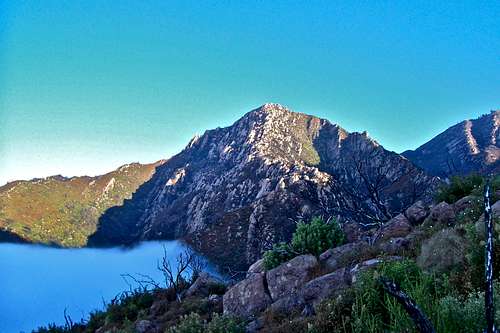
 red line shows Mission Ridge red line shows Mission Ridge |  Lower Part of the ridge Lower Part of the ridge |  Middle Part of the ridge as seen from Tunnel Trail Middle Part of the ridge as seen from Tunnel Trail |  High point of the ridge is behind the rocky outcrop High point of the ridge is behind the rocky outcrop |
 Double summits seen from the highest saddle on the ridge
On one of our weekend outings a few years ago, my wife and I noticed something we had never seen before. Half way up Tunnel Trail around a sharp turn to the right the thick brush seemed disturbed. It was obvious that someone had ventured into where there was no trail. I suggested to explore a bit further. We headed into thick brush only to find a path climbing up a steep spine of a rocky ridge we had been accustomed to ignore. We climbed on moderate class two rocks for a few hundred feet to reach the high point of the ridge. We marveled at our new discovery and wondered about the best way down. We found a very steep and sandy way down the north side through heavy brush.
The Revisit
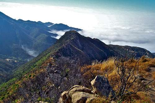
 Looking down at Tunnel Trail
 The high point on the ridge
Following the devastating forest fires of 2009 and subsequent reopening of Tunnel Trail to the public in 2010, we had to go back for another look. The point where the path for Mission Ridge splits off from Tunnel Trail is now clear and easy to find. The branches that poked you in the eyes a few years earlier are still there, but they are blackened remains of what they once were. The ridge is easier to negotiate now since you have only the rocks to deal with. Reaching the high point of Mission Ridge is well worth the effort. The 360 degree views are awesome. You have the Pacific Ocean and the Santa Barbara Channel Islands to the south, the coastline of California stretching from east to west and the rugged Santa Ynez Mountains and La Cumbre Peak and Arlington Peak to the north.
Getting there
 Looking down toward Rattlesnake Canyon
 Peace Sign barely visible
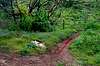
From US Highway 101 in Santa Barbara take the Mission Street off ramp and turn right at the light. Continue on Mission street passing in front of the mission building to a stop sign at the intersection with Foothill Road. Turn right onto Foothill Road and left onto Tunnel Road. You will come to a fork. Take the left fork and drive all the way to the end. You can park on the right hand side of the road within the white lines. Additional parking may be found before the end of the road. Please do not park in the side streets. They are all private roads.
To get to Mission Ridge hike the first half of Tunnel Trail. About a few hundred yards before reaching the connector trail to Rattlesnake Canyon and a sharp turn to the right, look for a steep minor trail to your right. This is your path to reach the high point on Mission Ridge. The path will take you through some steep terrain peppered with class 2 rocky sections.
Trail Details
| Benchmark | Tunnel Trail to Mission Ridge trail fork coordinates | elevation | Distance from trailhead |
 Trailhead Trailhead | N 34.46498--------W 119.71259 | 1002 ft | 0 |
 Tunnel Trail Tunnel Trail | N 34.47059-------- W 119.70688 | 1280 ft | .85 mile |
 Take the left fork Take the left fork | N 34.47242--------W119.70295 | 1650 ft | 1.5 miles |
 Mission Ridge trail Mission Ridge trail | N 34.47825--------W119.70039 | 2394ft | 2.5 miles |
Camping
 Looking west from the top of La Cumbre
Unfortunately, there are no campgrounds close and convenient to the city of Santa Barbara.
There is, however, one very large and well developed campground at Cachuma Lake, and a few less developed ones along Paradise Road off Highway 154. There are also a few campgrounds along Highway 101 at El Capitan State Park and Refugio State Park.
El Capitan Beach Camping
Refugio State Beach Camping
Cachuma Lake