
|
|
Mountain/Rock |
|---|---|
|
|
46.94431°N / 10.91959°E |
|
|
Otztaler Alps |
|
|
Hiking, Scrambling, Via Ferrata |
|
|
Spring, Summer, Fall |
|
|
9957 ft / 3035 m |
|
|
Overview
 Summit View: NORTH
 Südlicher Polleskogel,Schwarze Schneid and Linker Fernkogel
 Summit View: SOUTH
 Mainzer hohenweg
 Seekogel (3358m) as seen from Polleskogel
 Sudlicher Polleskogel (3035m)
 Watzespitze (3534m) from Polleskogel
Südlicher (=Southern) Polleskogel is a beautiful 3000meter peak located in the heart of the Otztal Alps. It is the southernmost 3000 meter peak of the Geigenkamm. Being a part of the famous Mainzer hohenweg ,Südlicher Polleskogel is a well visited peak in the area. Furthermore, it is also a fast 3000 meter peak because of its location close to the Soldener Gletscherstrasse (Glacier-road).
The peak is accessible from different locations. It can be climbed from the Russelheimer Hut (formerly Chemnitzer Hut, approach from North), from Braunschweiger Hutte (West) and from the glacier road (South). The peak is often climbed as part of the Mainzer hohenweg-route. This route leads over a big part of the Geigenkamm ridge and is especially fun for the 3000meter peak- collector. In a single day you can ascend Südlicher Polleskogel (3035m), Nördlicher Polleskogel (3015m), Wurmsitskogel (3078m), Gschrappkogel (3191m) and Wassertalkogel (3242m).
The routes are not too difficult but some experience is needed. The approach from the South involves a nice Via Ferrata (UIAA grade I). The summit block (both Routes) requires some scrambling (Grade I-II, no secured lines).
The location of Südlicher Polleskogel in the heart of the Otztal alps is the reason for its popularity and beautiful views. Towards the west lies the rugged Pitztaler valley with it’s famous peaks like Watzespitze, Verpeilspitze and Seekogel. Towards the South the views are on the famous Soldener Glacier with Innere and Aussere Scharze Schneid and Gaislachkogel. Last but not least, the views on the glaciated North Face of the Wildspitze are impressive.
 Südlicher Polleskogel Summit with Watzespitze (3534m) in the background Südlicher Polleskogel Summit with Watzespitze (3534m) in the background |
Route Overview
 Ascending the summit Block
 Signpost at the split-up: Follow ''Russelheimer hutte''
 View from Pollesjoch (2940m)
 Via Ferrata Ending @ Pollesjoch
 View up from the Starting Point towards Pollesjoch
 Overview Map Solden AREA
Normal Route
The Normal Route starts at the end of the Glacier street. It can be seen on the map below marked in RED. This road-end contains a large parking place where parking is free of charge.
Leave the parking place in a North-West direction. (This is the only way that goes up in elevation and is marked with red-white-red stripes, it simply cannot be missed). This first part is an easy hike-up (graded T3). Following this trail eventually leads to a split-up. Going left will lead you to the Pitztaler Joch and to the Braunschweiger Hut.
Please note: This road is CLOSED because of increasing danger of falling rocks. We saw some people ignoring the closure and they got in all kinds of trouble, with rockslides coming nearer and nearer before they eventually turned back. So don't go here!!
Back to the split-up: Take a right here (follow the signs ‘’Pollesjochl’’). Shortly after the beautiful Via Ferrata starts. Graded I, it is technically easy but nonetheless very beautiful. The Via Ferrata goes up until you reach Pollesjoch at 2940m. From here you get your first sight into the Pitztal. At Pollesjoch you are now officially at the Mainzer Höhenweg. Follow the road towards the north (some secured lines), at your right hand you will see the Polleskogel. In less then 5 minutes you will arrive on the ridge (Geigenkamm) and have scpecatacular views into the Pitztal (west) and Pollestal (east.)
From this point follow the North-East ridge towards the small and rocky summit of Südlicher Polleskogel. This last part is short (10minutes), but requires some experience. It is graded I-II, but contains no secured lines or whatsoever and is a bit exposed. After this passage you will arrive on the small rocky summit.
Ascent time: 1-1.5 hours
Descent goes back the same way until you arrive on the Geigenkamm-ridge. From here a beautiful option for descent is to descent into Pollestal. This route can be seen in the map below and is marked in BLUE. Pollestal is very rugged, quiet and beautiful. Descending further down will get you back in the main Otztaler valley close to Langenfeld.
Descent time: 3-4 hours
Alternative:
A great alternative is to do the Mainzer Hohenweg from the Russelheimer Hut to the Braunschweiger Hut.(or the other way around). This route follows the Geigenkamm ridge and therefore includes beautiful views into both the Pitztal and Otztal. It also leads over the following 3000meter peaks:
Südlicher Polleskogel (3035m), Nördlicher Polleskogel (3015m), Wurmsitskogel (3078m), Gschrappkogel (3191m) and Wassertalkogel (3242m).
For more information please see the Mainzer Hohenweg Route Page
 Descent Route into Pollestal marked in BLUE
 Normal Route: Ascent from Glacier road marked in RED, descent towards Pollestal in BLUE
Getting There

Annotated 360° panorama from Nördliches Pollesjoch.
Sudlicher Polleskogel is captioned as Nordlicher Polleskogel in the Panorama
Route Description:
From the West:
Vorarlberg - Tirol via Arlberg Pass or trough Arlberg Tunnel (S 16 Federal Road) - direction Landeck - change to A 12 Autobahn - exit: Ötztal - B 186 Federal Road (35 km) to Sölden
From the North:- Bad Tölz - Achen Pass - B 181 Federal Road - Jenbach - A 12 Autobahn - Innsbruck - exit: Ötztal - B 186 Federal Road (35 km) to Sölden - Pfronten - Reutte - Fernpass - Imst - A 12 Autobahn - exit: Ötztal or B 171 Federal Road to Ötztal (no Vignette toll-sticker required!) - B 186 Federal Road (35 km) to Sölden - Garmisch Partenkirchen - Mittenwald - Scharnitz - Seefeld - Telfs - A 12 Autobahn - exit: Ötztal or B 171 Federal Road to Ötztal (no Vignette toll-sticker required!) - B 186 Federal Road (35 km) to Sölden
From the East:
Munich or Salzburg - A 93 Autobahn to Kufstein - A 12 Autobahn direction Innsbruck - Ötztal - B 186 Federal Road (35 km) to Sölden
From the South:
Merano/South Tirol - via Timmelsjoch Pass to Sölden. High Alpine road leading up to 2.500 m above sea level. The Pass is open only from the beginning of June to the middle/end of October. Toll road!
You can find a RoutePlanner here!
Soldener Glacier Road
See MAP Above: The Glacier road starts just south of the village of Solden. It is the first exit after you leave solden in a southern direction. The signs are very clear!
You have to pay an entrance fee of about 20 euro's for this road.
More info: Glacier Road
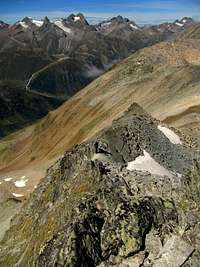
 Südlicher Polleskogel in front; In the Background Schwarze Schneid & Linker Fernkogel
 The Summit block of Südlicher Polleskogel
Weather & Glacier Road
 Polleskogel Ridge Panorama
Weather:
Weather Forecast Solden
Glacier road info:
Glacier Road
Maps & Books
 Leichte 3000er
Book:
Leichte 3000er mit Weg: Die 99 Schonste Touren (in German)
2004, Bruckmann, ISBN 3-7654-4188-0, 144 pages, ca. 120 Photos
Map:
--> AV-Karte, Ötztaler Alpen, Blatt 30/6 (Wildspitze).
Camping / Huts
There are some beautiful campsites in the main Otztaler valley:Camping Otztal Langenfeld
NaturCamping Otztal
Huts:
Braunschweiger Hut
Russelheimer Hut
 Braunschweiger Hut Braunschweiger Hut |  Russelheimer Hutte Russelheimer Hutte |
|---|