
|
|
Mountain/Rock |
|---|---|
|
|
48.66282°N / 121.52039°W |
|
|
Mountaineering, Scrambling, Skiing |
|
|
Spring, Summer, Fall |
|
|
7061 ft / 2152 m |
|
|
Overview
mmmmmmm… Bacon! Tasty!
OK, you knew that was coming, right? Had to get it over with.
Bacon Peak is a classic example of a much overlooked North Cascades mountain, mostly ignored probably for three main reasons: Moderate altitude, not easily accessed, and not many steep lines. In fact it resembles more of a plateau than a peak. Almost flat as a pan on top, like for frying tasty salty meats… alright, I’ll stop.
Seriously, anyone wanting to be familiar with all the flavors of fine climbing that the North Cascades has to offer really has to sample some Bacon.
OK, OK, I’m really done this time. Good thing there isn’t a rock route on this thing that involves “slabs”. Or that I don’t have a climbing partner named Kevin.
Despite the peak’s moderate altitude and low gradient on most sides, it is amazingly alpine in feel. The large glaciers on its north and east sides are quite impressive, and the one partly encircling the summit has an interesting massive wind cirque. At times you might feel as if you are on a genuine arctic icecap, always a welcome sensation to a North Cascades rambler. If you are a ski mountaineer and make the trip in here during your season and hit good weather, you are in a for a treat, as the glacier slopes of Bacon Peak, in fact much of the surrounding high country, is perfect for relaxed cruising.
There appears to be two established approaches. There is one from the southeast, leaving the end of the Bacon Creek road and ascending a northwest trending ridge. I cannot speak to that one, having never used it. Steph Abegg, always a reliable source of good info (and fantastic photography!), has gone up this way and posted her trip, there is a link below. Her posting includes a good map with her route clearly marked. One note: She did this in Spring, which means brush would have been snow-covered, so anyone planning to follow this in Summer should plan accordingly.
Getting There - The Mount Watson High Route

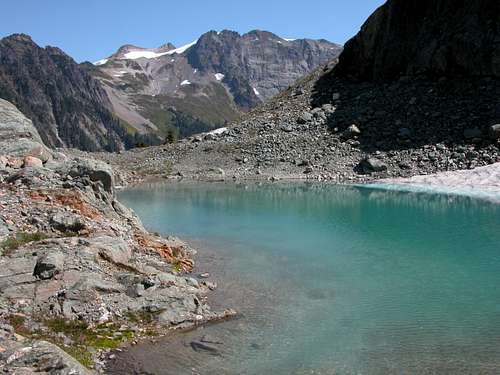
Watson Lakes, Bacon Peak far away
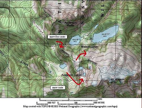
My approach and climb is via a traverse of Mount Watson’s north slope: Drive to the Anderson Butte/Watson Lakes trailhead, accessed from the Baker Lake Hwy from Hwy 20. (Interesting drive across the narrow top of the dam). Hike the trail only about a mile to the junction where the right branch descends to the lower Anderson Lake, and the left branch goes to the Watson Lakes. You are faced with a significant obstacle at this point, a 400 foot tall cliff that runs SE to NW, separating the lower and upper Anderson Lakes areas. You can clearly see this on the topo map, the topo lines are quite close. I have found two ways to get around this.
 Mount Watson High Route
Pick your way, depending on whether or not deep snow is a factor
Summer (snow-free): Hike to the “pass” just east of the trail junction, or at the NW end of this cliff, and then go off-trail carefully picking your way up. A non-technical way reveals itself, but takes some looking. There is boot-built path in places, obviously quite a number of people have done this, probably most just going to the upper Anderson Lakes. If things start to get really exposed, you are off route. Once on the ridgetop, the way becomes fairly easy, continue toward the upper Anderson Lakes, then turn the corner out onto Mount Watson’s north slope at about 5100 feet.
Snow-season: If doing this when snow covered, ascending the NW end of this cliff barrier becomes dangerous; a better approach may to go to the lower Anderson Lake, then look to the SE where the vertical cliff obstacle runs into the base of Mount Watson’s west slope. There is a feasible snow-covered tilted shelf up through the woods and then in the open here (see photo), I descended it recently when coming from the east at the end of a multi-day ski traverse, so I can attest that it does go though, ice-axe and crampons would make it feel safer. It was the only relatively safe way through that I found under heavy snow conditions (of course allowing for avalanche considerations).
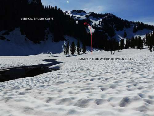 Getting past the Anderson cliffs in snow season, from lower Anderson Lake
Once up on the upper Anderson Lakes shelf, head easily NW then turn the corner out onto Mount Watson’s north slope at about 5100 feet. The north slope of Watson is relatively easy cruising over terrain only recently vacated by glacier. If are you there in snow season and on skis, it’ll be pure joy.
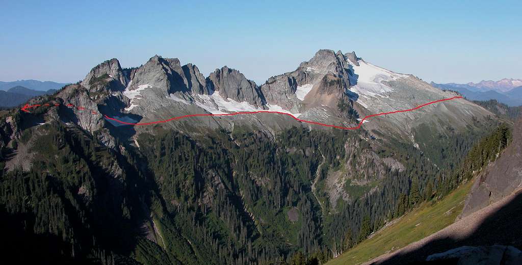
As you travel, Bacon Peak comes into view, with its distinctive summit ice cap (see image section for additional photos, labeled “Bacon from Watson north slope”).
Bacon as seen from Mount Watson north slope
There is a buttress descending northeast from Watson that you need to drop below; continue a descending traverse to turn the corner just below the 5000 foot level, then a slightly rising traverse will take you to the key gap in the main east-west ridge at 5360 feet, just west of point 5580.
The next obstacle in this maze is getting over to Bacon Peak from this key gap in the main east-west ridge at 5360 feet. The Beckey guide and a few on-line blogs suggest dropping to the tarns SE from this gap, then working your way up Bacon’s south side. There is much better way:
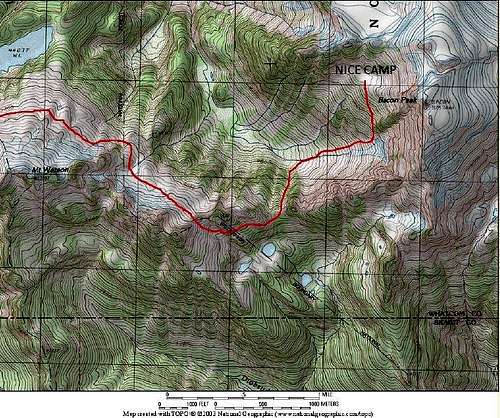 Route from Watson's north slope to camp below below Bacon Peak
Instead, go easily through the 5360 gap and continue eastbound on the south side of the ridge as the terrain allows, dropping slightly, perhaps 300-400 feet. You are aiming for the next low spot on the east-west ridge, to cross back over at about 4900 feet. There are minor challenges that require a bit of exploring, such as short buttress, but there are ledges around to easier ground. Once you’ve gotten around the side of point 5580, come back to the ridge gap at 4900 and drop straight down northbound; despite the steepness travel is relatively easy, not too heavily brushed, straight to the bottom of the basin where it opens up at about 4000 feet. Now the way is quite clear and brush-free, open to ascend rock strewn meadowy slopes up Bacon. There is a nice basin for camp, obvious on the topo map, at 5900 feet. The summit is then an easy stroll from here, going past the aforementioned wind cirque/ice cliff. There are a few easily avoided crevasses on the summit icecap. See image section for a series of photos illustrating this icecap.
Despite all this looking complicated on the map, it goes surprisingly easy, taking only about 7 to 9 hours from the trailhead. There are undoubtedly quite a few possible variations in this approach, it’s just the way I went and found it enjoyable.
Red Tape
The initial hike in starts at a forest service trailhead, so parking permit required. You soon enter the Noisy-Diobsud Wilderness, then after you leave the trails you end up inside the North Cascades National Park, so regulations for those two entitites apply.
When to Climb
Summer and Fall for scrambling. Spring for skiing.
External Links
Steph Abeggs excellent report and stunning photography:
http://www.stephabegg.com/home/tripreports/washington/northcascades/bacon