
|
|
Mountain/Rock |
|---|---|
|
|
48.17999°N / 120.85836°W |
|
|
Mountaineering |
|
|
Summer |
|
|
8421 ft / 2567 m |
|
|
Overview
Dumbell Mountain is one of Washington's highest 100 peaks with a pleasant scramble route and magnificent views. There is even a small bivy site at the summit.Dumbell is located ENE of Glacier Peak (roughly halfway between it and Lake Chelan) and four miles south of Bonanza Peak. Railroad Creek (with tributaries Rubin and Big) bounds Dumbell on the west, north, and east. Phelps creek lies to the south.
While Dumbell is a prominent double-peaked massif, its neighbors (Fortress Mountain, Chiwawa Mountain, Bonanza Peak, peaks of the Fernow Group, and Buck Mountain) are even higher and thus divert attention from this otherwise pleasant climb. Nearby Greenwood Mountain (confusingly also known as NE Dumbell) is a half-mile away and just a hair lower (8400+ ft). Greenwood is typically climbed in conjunction with Dumbell.
Dumbell is composed of very old igneous rock: a gneissic hornblend quartz diorite. While Dumbell is devoid of significant glaciers, there is a remnant ice sheet on its north side and a permanent snowfield cradled in the high cirque on its east side.
History
Dumbell was named by A. H. Sylvester. While prospectors likely roamed high on its slopes, the first recorded ascent was by Richard Alt and George Fahey (August 1932) via Phelps Creek. No winter ascent has been recorded.Getting There
The natural approach is via the Phelps Creek Trail. We quote from the Maude page: "[D]rive east from Stevens Pass or west from Leavenworth on US Highway 2 and turn north toward Lake Wenatchee [at Coles Corner]. After the Wenatchee River bridge go right at a Y, then drive 1.1 miles on county road 22 and turn left on Chiwawa River forest road number 62. Drive 24 miles to near the end of the road [if you get to Trinity camp, you've gone too far] and turn right on the Phelps Creek road. Drive to the end of this road to the trailhead." Much of this approach road is dirt and can be slow. The trailhead is at 3,500 ft.Red Tape
Dumbell and most of the approach are in the Glacier Peak Wilderness; The "Leave No Trace" policy applies. A Trail Park Pass was required for the Phelps Creek Trailhead, but as of Aug 2015 it appears that this is no longer necessary.Approach & Camping
Follow the well-maintained Phelps Creek Trail through the far side of beautiful and popular Spider Meadow (6.5 miles) and keep right at the trail junction (the left fork climbs steeply to Spider Gap). Continue 0.5 miles into Upper Phelps Creek Basin (est 5400'). Distance: 7 miles with 1800 ft of hiking from the car.There is good (though not abundant in terms of pre-used flat spots) camping in the Upper Phelps Creek Basin, but one could also camp earlier, e.g., in Spider Meadow, and there are many fine sites in the forest along the Phelps Creek Trail. There is also a fine spot five minutes from the trailhead (convenient for a car camp prior to a (strenuous) one-day ascent). One could also bivy higher if desired. Certainly the higher you camp, the more 'pure' the water sources will be.
Southwest Route
It is a bit hard to tell what is Dumbell's true summit until you get much higher, but the highest peak is at the east end of the E-W crest.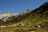
A long ridge cradles the talus & snow basin on the N; the true summit is on the far E end of the ridge. Your plan is to ascend to the notch just W of the summit and follow the ridge to the top. However, two short cliff bands stand between you and the ridge.
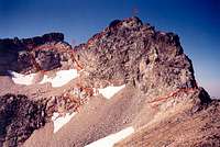
The route is noted in this very late-season picture. Ascend the basin until beneath the summit (points A and B. Climb moderately steep snow and then a short section of Class 2 or easy Class 3 to beat the first cliff band. The second band is a bit harder with two main routes:
The easiest way is on the left - starting at C a very dirty gully leads though the difficulties and after 30' one reaches D and has class 2 ledges heading upwards and right to the notch F at ridge crest (see photo of ledges). However. the gully is very loose (even for the Cascades) and unpleasant.
A cleaner route climbs directly up and leftwards from under the notch E, following another fault line, but this is more exposed and feels more like Class 3-4. A final option might be to stay to the R of the cliff band.
Once at the notch on the ridge crest F, follow it (or traverse slightly on the N side) to the top - easy but moderately exposed Class 3.
Time: 3-4 hours from upper Phelps Creek to the summit. It is worthwhile to climb this in conjunction with Greenwood Mountain (access exposed ledges via the first easy notch S of Dumbell H). Allow an extra 2 hours to go to Greenwood and back starting from the south foot of Dumbell's summit mass). An ice axe will likely be helpful, even in late season.
CEIGE - Aug 1, 2015 7:03 pm - Voted 10/10
No trail park pass required at trailheadI was up at the Phelps Creek Trailhead on July 27-29, 2015. There was a big sign posted on the trailhead that said that one did not need a trail park pass to park that the trailhead.
dsweld - Aug 2, 2015 6:21 pm - Hasn't voted
Re: No trail park pass required at trailheadWeird / great! (I got a ticket there a few years ago for failing to do so!) I'll make a note of the change.