
-
 25604 Hits
-
 79.78% Score
-
 11 Votes
|
|
Mountain/Rock |
|---|---|
|
|
47.42112°N / 120.80223°W |
|
|
Kittitas/Chelan |
|
|
Scrambling |
|
|
Spring, Summer, Fall |
|
|
7223 ft / 2202 m |
|
|
Overview
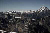
 Enchantments from Upper Navaho
 Enchantments from County Line Trail
Navaho is a great early season objective, as are most of the Teanaway Peaks. The area melts out much earlier than the West Slope of the Cascades, and is relatively snow-free by June while the West is still blocked by heavy snow. The weather is also more reliable on this side, being the sunny side of the Cascade Crest.
Navaho is easily accessible by way of Stafford Creek. The moderate distance of this trip (12 miles roundtrip) makes this a reasonable day outing. Navaho is therefore a fairly frequently climbed peak.
Getting There
 Near Navaho Pass
 Final Scramble
 Near Navaho Pass
 Meadow with Camps
Hike up the trail about 3.5 miles, crossing a very marshy open meadow. While the meadow is marshy, there are great camps here in the woods adjacent to the meadow, with water rushing down stone faces in a mini-waterfall. Cross the meadow the pick up the trail, which is faint in the meadow, and find the junction with the StandUp Creek Trail. Go right at the junction, and in 1 more mile, arrive at Navaho Pass and a junction with the old County Line Trail. Head right (East) on the trail, traversing the ridge line until arriving at the south ridge of Navaho Peak. From here, it is an easy 700 foot ridge scramble to the summit.
Alternatively one can take a shortcut where two creeks merge at around 3 miles from the trailhead. Head directly up steep slopes of the creek drainage coming from the northeast, arriving at the col below the Southeast Ridge of Navaho Peak. This approach cuts approximately 2 miles off of the trip. By the standard approach by way of Navaho Pass, the trip stats are as follows: 12 miles roundtrip, 4000 feet elevation gain, Class 2.
Red Tape
A Northwest Trailhead Park Pass is required ($30/year) to park at Stafford Creek trailheads. Alpine Lakes Wilderness permits are required but are available at the trailhead on a self-service basis.Camping
There is a lovely camp located about 3.5 miles up the trail. The ground is dry, and there is a wonderful water source in the form of a mini-waterfall, but it is adjacent to a marsh which can be the source of bugs in season. Otherwise, camping opportunities here are very limited due to the dry nature of the trip.External Links
 Summit Views
 TOPO! Software Image
Cle Elum Ranger District
West 2nd Street
Cle Elum, WA 98922
(509) 674-4411
Snow conditions are available from the Summit at Snoqualmie Ski Areas (of which Alpental is one) at the following website:
Summit at Snoqualmie Snow Conditions
Also, webcams are available from the Washington State Department of Transportation at:
Snoqualmie Pass Web Cam