
|
|
Mountain/Rock |
|---|---|
|
|
38.67420°N / 106.2464°W |
|
|
14271 ft / 4350 m |
|
|
Mount Antero Overview
Mount Antero attracts people for many different reasons. It is the 10th highest mountain in Colorado, and that alone makes it
an important destination for many. It offers several climbing routes which are not terribly difficult. A wealth of fine gemstones have been mined from Antero's slopes, and this makes the mountain popular among rock hounds. Not coincidentally, there is a good, 4WD road on the peak's west side going nearly to the summit. This makes Antero a popular mountain for off-road enthus
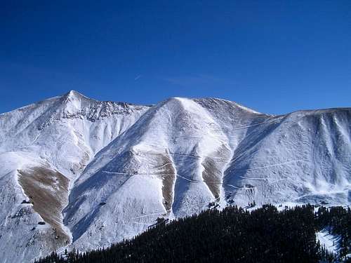
iasts, who keep the area "humming" in the summer. The San Isabel National Forest, of which this mountain is a part, affords countless recreational opportunities. For all these reasons, Mount Antero is a popular destination. Antero is not the most stunning peak from the standpoint of scenery and beauty. It's difficult to find spectacular angles for photographs of this mountain.
Mount Antero
Hiking Mount Antero is not especially difficult, as thousands can testify. And as with most areas in the Rocky Mountains, this area affords great scenery, whether you are looking up at, or down from this lofty mountain. The following sections and photos will highlight these aspects of the mountain, and offer some guidance for climbing Mount Antero.
The peak is located in the Sawatch range between the towns of Buena Vista and Poncha Springs. It borders the Arkansas River valley on the west and is clearly visible from U.S. 285.
Mount Antero is located in the Mount Antero Quadrangle and is in Chaffee County. The current elevatiion has been changed due to recent LIDAR findings.
Chief Antero

The Ute Indian tribes are the oldest continuous residents of Colorado. The earliest Utes are said to have populated the eastern slope of the Rocky Mountains and were hunters and gatherers.
Before the Europeans arrived, the Ute (which means “land of the sun”) were composed of seven bands; the Mouache, Weeminuche, Uintah, Yampa, Parianuc, Tabeguache and Capote. The latter were dwellers of the San Luis Valley and Northern New Mexico. The Tabeguache lived in the Gunnison and Uncompahgre River Valleys. These diverse bands now make up the present day Southern Ute, Ute Mountain Ute and Northern Ute Tribes.
Chief Antero was a member of the Uintah band of the Ute. Also known as Graceful Walker or Chief White Eye because of blindness in one eye, Antero worked to promote peace during the uprisings of the late 1860s and 70s. He was also one of the signers of the Brunot Treaty. He had a fair amount of influence in affairs on the Uintah Reservation due to his cooperation and friendliness with the white man.
Antero was used as a source for ethnological studies by John Wesley Powell and was photographed by Jack Hillers, who accompanied Powell on his Grand Canyon expedition and was also put in charge of taking portraits of Indian leaders when they visited Washington, D.C.
Mount Antero is the highest Colorado mountain named after a native American Indian. Neighboring mountains Tabeguache, Shavano, and Ouray, are also named after prominant Ute Chiefs.
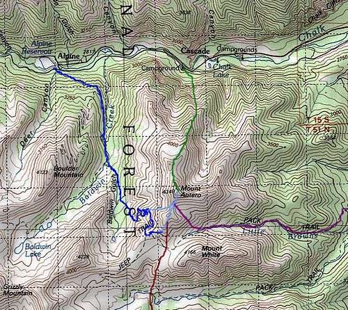
Getting There
| Baldwin Gulch | |
| Cascade | |
| Little Browns Creek |
Routes Overview
West Slopes (standard route): Baldwin Gulch Trailhead. Follow four wheel drive road almost to the summit. Class 2 hike. Twelve miles round trip. 5000' elevation gain.
 Routes Overview
Little Browns Creek: Browns Creek Trailhead. Recommended for solitude. Follows north side of Little Browns Creek. Class 2. Fourteen miles round trip. 5350' elevation gain. South Slopes, Browns Lake: Potential backpacking trip, with overnight at Browns Lake. Follows roads and trails. Class 2. Twenty-two miles round trip. 5400' elevation gain. North Ridge: Cascade Trailhead. Moderate snow climb, seasonal. Ascends large avalanche chute. Gully is unpleasant scree when snow-free. Class 2. Seven miles round trip. 5300' elevation gain. North Face Direct: Technical climb, starting near the Cascade campground trailhead.
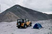 Camping at 13,700'
Camping / Red Tape
Mount Antero is situated in the San Isabel National Forest, where there are countless recreation opportunities, and dozens of campgrounds.. Visit the official Forest Service web site here. There are at least four campgrounds along Chaffee County Road 162 within three miles of either Baldwin Gulch or Cascade Trailhead. Three of these (Cascade Campground, Chalk Creek Campground, and Mount Princeton Campground) accept advance reservations. Visit ReserveUSA.com, or call toll free, 1-877-444-6777 to make reservations.
 Gem Mine
Camping in undeveloped areas is also permitted in many cases and with certain restrictions. All visitors and users of the National Forests are subject to Federal Regulations. The forest service publishes many rules and guidelines, addressing camping, vehicles, camp fires, pets, and other issues. You must pay a fee to use certain developed sites and facilities. Such areas are clearly signed or posted as requiring a fee.
Mountain Conditions / When to Climb
 Antero Aquamarine Crystal
Current, local conditions are maintained by the Forest Service at their newly updated web site. Besides the current weather, they publish campground status, road conditions, trail status, and closures. You may also call the Forest Service office at 719-553-1400. The summer months provide the best time to climb Mt. Antero. You are by no means assured of safe conditions on any day of the year, of course. As always, use good judgment, and Check the Weather Forecast before you go. NOAA Point Forecast for Mount Antero.
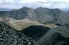
Summit Shots and Views From Antero
Mount Antero provides great views of the Sawatch range. At the summit, a 360 degree panorama.
 |
 |
 |
 |
 |
Gems
Gem Mine
In 1881, a Salida man by the name of Nelson Wanemaker discovered gems high on Mount Antero. His discovery was publicized a few years later, and Mount Antero became a famous collecting area for aquamarine, phenacite, fluorite, topaz, and smoky quartz crystals. It boasts the highest concentration of minerals anywhere in the nation.
Antero Aquamarine Crystal
There are mining claims in the area, and feuds over disputed claims. Amateur diggers still occasionally report finding a good quality crystal here, but don't count on it. With findings far above timberline, this is the highest known gem locality in the United States. Buena Vista Gem Works provides lots of interesting information for collecting aquamarine. I'll bet you didn't know that Mount Antero Treasures sells skin care products made from Mount Antero aquamarine gem clay & minerals. So visit Mount Antero, to keep your skin looking younger! Ha!
Mount Antero Road
A 4-wheel drive runs from the Baldwin Gulch Trailhead to within a few hundred vertical feet of this mountain's summit, for a total distance of about 9 miles. It was built in the early 1950's by a company that hoped to mine beryl. The beryl mining proved to be uneconomical, but the road they left behind is pretty good. Depending on your perspective, you might consider it a great convenience for rockhounds and peakbaggers, or a blight on an otherwise attractive mountain. The road is ranked "Moderate" by The Colorado Association of 4WD Clubs. This organization is seeking people to "adopt" this road.
 |
 |
 |
 |
 |
External Links
Wikipedia article Skiing Mount Antero Mount Antero on 14ers.com Mount Antero on sangres.com Trip Report by Theron Welch