
|
|
Mountain/Rock |
|---|---|
|
|
36.90390°N / 118.3878°W |
|
|
12372 ft / 3771 m |
|
|
Overview
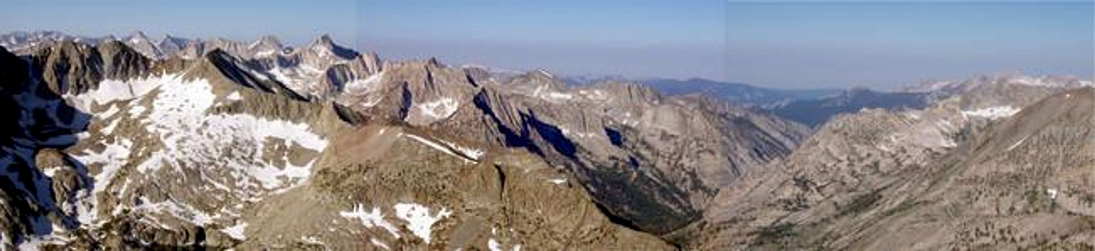
Cedric Wright is located in the Sawmill Pass vicinity. It's lower elevation and relative remoteness cause it to see less than a dozen visitors a year. "The mountain was named for George Cedric Wright (1889-1959), an internationally known photographer whose photography has made a significant contribution to the appreciation of the natural scene(from the USGS website)." Wright was one of the first High Sierra photographers, following in the footsteps of John Muir. His works can be viewed in his book Words of the Earth.
The mountain itself is not technically difficult, easy class 2 by the normal route. The approach on the other hand is truly a journey and a half. Either via the Sawmill Pass Trail or Armstrong Canyon, both require large amounts of elevation gain. Cedric Wright sits high above the Woods Creek drainage, giving it beautiful views North, West, and South.
Getting There
Cedric Wright is bordered to the North by the Pinchot Pass basin and to the South by the upper Woods Creek drainage. The most common approaches to the Mountain are via the Sawmill Pass Trail and a traverse over Colosseum Mt from Armstrong Canyon.
The Sawmill Pass Trail is the more common path, because it is the least technical. To reach the trail head take Highway 395 to Black Rock Spring Road 8 miles North of Independence. Turn West on Black Rock Springs and follow it until it dead ends on Tinemaha Rd, turn right(North) here. After another 2 miles you'll take a left onto Division Creek Rd, drive up past the Powerhouse and to the trail head turnout on the left hand side. The road continues past the trail head up into Armstrong Canyon, those wishing to take the Armstrong Canyon approach can continue up the road, though a 4wd is recommended to fully utilize this road.
The Sawmill Pass Trail starts at a brutal 4650ft and climbs relentlessly for 10 miles to Sawmill Pass. Prepare for an early start, since summer temps can peak 100 degrees in the valley and there is no water until one reaches the shaded "Hogsback" in Sawmill Canyon. Once in the canyon the trail climbs through mostly forested slopes to Sawmill Pass at 11347ft. From there it is an easy cross country hike North across the basin to the mountain.
For those climbing up Armstrong Canyon, continue up the road until you can/don't want to drive any further. Most cars can make at least Scotty Springs at 5800ft. Start hiking from where you parked up the Canyon. It is relatively easy cross country until you reach the head of the canyon and Class 3 Armstrong Col. Once at the top of the Col you have a choice of following the ridge line over Colosseum Mt or dropping into the basin to the SW. These routes all require more route finding and are more technically challenging.(See the View More Info section for more on this route)
 |  |
Red Tape
Sawmill Pass lies within the Bighorn Sheep Zoological region. The area 1 mile directly North of the pass and the basin South of the pass are off limits half the year, check with the forest service for dates(I believe July 16-Dec15).
Most people will do this peak as an overnight hike up the Sawmill Pass Trail. Any overnight stay in the wilderness requires an overnight permit from the Inyo NF. Permits are free for walk-ins or can be reserved for $5 a person. Currently one can still request an after hours pickup, which is recommended so one can start at dawn and avoid the heat. Day hikes do not require a permit, though on the most fit should ever attempt to day hike this peak.
Letter from the Inyo NF regarding Night Drop Box Permits
"After due consideration, the management of Sequoia and Kings Canyon National Parks is requesting that the Inyo National Forest implement a change in how wilderness permits are issued to those individuals and groups who camp in the parks. We are requesting that night drop boxes no longer be used and that all permits which include camping in these parks be issued in person. This action will be phased in throughout 2005 and fully in-place in 2006. The primary reason for this change is to more adequately protect wilderness resources in the parks."
National Park Service May 2005
When To Climb
The peak is most commonly climbed between June and October. Though several winter ascents have been registered as part of ski tours across the Sierra. Before June an ice axe and crampons would be required for both the approaches and the actual peak itself.
Camping
Camping is allowed anywhere in the basin North of Woods Lake. The area South of the Pass around Mt Baxter is off limits half of the year due to Bighorn Sheep restrictions.
Matthew Holliman - Jul 25, 2005 7:52 pm - Voted 10/10
Untitled CommentEric--Your notes seem fine to me. I have a description of the drive/TH approach on the Eastern Sierra logistical page which you can plagiarise or link to.
From the end of the road, if you follow the use trail up the canyon to the bowl below Mt. Perkins, there are two options: head left (south) to a snow-filled couloir that leads up to what I believe is Armstrong Col, or right (north) and then follow the Sierra Crest south, tagging Mt. Perkins along the way. Armstrong Col requires axe/crampons, but the approach via Mt. Perkins melts out very early (leaving a thoroughly unpleasant sand climb behind in order to reach the crest).
Either way, the best way to Mt. Cedric Wright from Armstrong Col is to continue south along the Sierra Crest to Colosseum (exposed class 3) and then descend Colosseum's sandy west ridge to the saddle. It's possible to descend the sandy southwest side of Armstrong Col to the basin west of Colosseum, from where Colosseum Col (the Colosseum-Cedric Wright saddle) is reached trivially--but it seems silly to bypass Colosseum, especially as its north ridge is a nice climb and it doesn't involve much extra elevation gain vs. dropping down into the basin.
By the way, I believe there's an error in Secor's 2nd ed., in which he says the col is 0.8mi north of Colosseum; it makes more sense that Armstrong Col is 0.8mi NW of Colosseum Mtn. (This seems to correspond to what looked like a snow couloir from Armstrong Canyon and easy slopes to the SW, and the elevation on my maps at this point is roughly consistent with his stats for the pass). None of my maps have a point "Peak 3705m" on them, which he uses as a landmark to identify the col's location.
StevenThaw - May 2, 2016 1:27 pm - Hasn't voted
SIERRA (not sierras)The SIERRA is one mountain range. Sierra Nevada is Spanish for "Snowy Range". The California Miwok named it "Kayopha -- The sky and the Peaks that touch it". John Muir called it "The Range of Light". Steve Thaw, Moraga, California
thebeave7 - May 2, 2016 2:00 pm - Hasn't voted
Re: SIERRA (not sierras)Thanks for the correction Steven. Been quite some time since I wrote and edited that description, but glad its still somewhat helpful. Eric, Formerly Lafayette, CA (now Boulder, CO)