Page Type Page Type: Mountain/Rock
Location Lat/Lon: 40.26640°N / 9.47430°E
Additional Information Elevation: 2933 ft / 894 m
Sign the Climber's Log

Overview


Bruncu Nieddu photo_id=97766

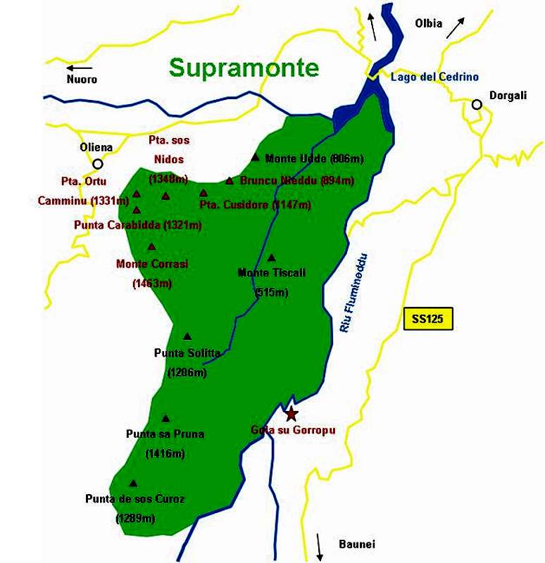
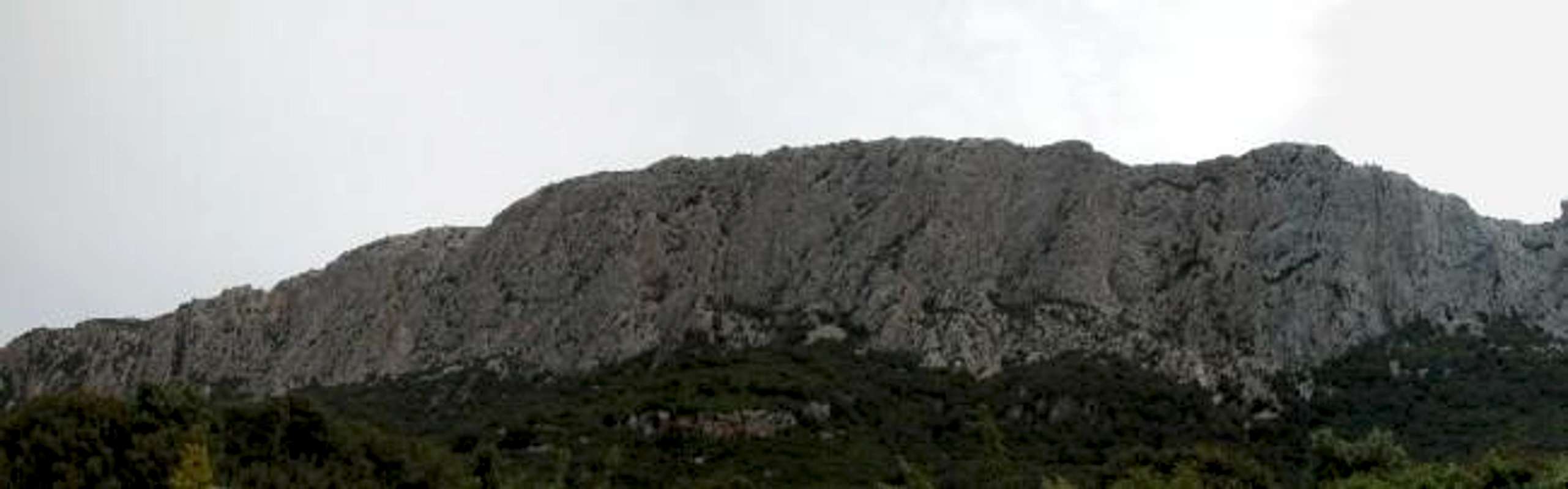
Bruncu Nieddu might be one of the lowest summits of the Supramonte Mountain Range of Sardinia / Sardegna but it is certainly one of the most impressive ones. It is part of the northern ridge of Supramonte, which consists of Bruncu Nieddu, Punta Cusidore, Punta sos Nidos and Punta Ortu Camminu. The mountain has an almost vertical northwest face, which drops from its summit for about 400m. Moreover it is host to a couple of the longest and most difficult climbing routes of the island.

The normal ascent to Bruncu Nieddu, though is much less impressive. It follows the Punta Cusidore normal ascent up Scala di Sovena (between Cusidore and sos Nidos) but then circles Cusidore on its southern side. You have to get into the saddle between the two summits (Cusidore and Nieddu) and then have to follow the Bruncu Nieddu western summit ridge.


Topo for climbing Bruncu Nieddu taken from "http://gomountain.procons.net/".

In climbing importance Bruncu Nieddu pales beside Punta Cusidore. There are - as said above - two long and difficult (6b+, 7b+) routes with an overall length of 270m both. Compare this with the six routes on Punta Cusidore, which almost reach a length of 400m. For those of you who understand Italian you can look at gomountain.procons.net. The topo above is linked to that page.

Gola su GorropuMonte CorrasiPunta CarabiddaPunta Ortu CamminuPunta sos NidosPunta CusidoreBruncu Nieddu

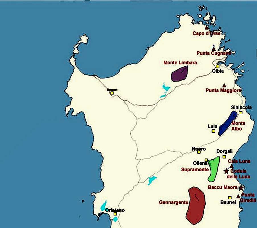
Interactive overview Map of Supramonte. The summits (and gorges) which have been submitted to SP are marked in red.

Getting There


Bruncu Nieddu photo_id=97772

Sardinia can be reached either by plane or by ferry. The main ports are Porto Torres and Olbia in the north and Arbatax and Cagliari in the south. Airports are at Alghero and Olbia in the north as well as (again) Arbatax and Cagliari in the south. For exploring the northeastern part of the island where most of the mountains are the best entry point is Olbia, which is where most flights go anyway.

Approaching the mountain from Olbia airport
Get on motorway SS 131 south in the direction of Siniscola / Nuoro. At the exit Lula / Dorgali get off and turn on SP38 south (again direction Dorgali). Shortly before you reach the town turn right on SP46, direction Oliena. Take this road up to a sign leading to the chapel of Nostra Signora di Monserrata. Here turn off left.

The following description is a little hard to understand on paper - nevertheless it is quite accurate. Follow the country road for 100m, then turn left. After another 600m turn right and head directly for Punta Cusidore. At an intersection the road turns left again and you follow it for another 600m. Here the asphalt ends and a gravel road takes you to a little fount. From here start to look for spaces to park your car. The road goes on for another 500m before the ascent trail (still a dirt road) starts climbing steeply upwards to the right.

Capo d'OrsaPunta CugnanaMonte LimbaraPunta MaggioreCala LunaPunta GiradiliMonte AlboSupramonteGennargentuCodula della LunaBaccu Maore

Interactive map of Sardinia and its mountain regions. Click on the regions, red triangles (mountains) or stars (gorges).

Red Tape


Bruncu Nieddu photo_id=92622

Fortunately in Sardinia there is absolutely no red tape to be found. Keep in mind that at the base of the mountain there are orchards, vineyards etc so leave your car in a place which leaves enough room for the farmers to do their work.

Also Bruncu Nieddu belongs to the Parco Nazionale di Gennargentu / Golfo di Orosei, so behave as in any natural park. You will see from the section below that there are lots of orchids in the area. These flowers are generally protected all over Europe so please leave them where they are!

Camping is forbidden in the natural park. The nearest possibility to place your tent is the restaurant Monte Maccione near Olbia - the trailhead for Punta Carabidda and Monte Corrasi. The proprietor will let you put up your tent in the restaurant garden. This might be an especially interesting place for climbers since Monte Maccione - below Punta Carabidda and Punta Ortu Camminu is a climbing hotspot itself with some 50 short routes with difficulties up to 8b+!

Bruncu Nieddu  photo_id=92624Bruncu Nieddu  photo_id=92625Bruncu Nieddu  photo_id=97773Bruncu Nieddu  photo_id=92626

When To Climb


Sardinia is a all year round location. Naturally weather turns worse in late autumn and winter but hiking - even climbing - is possible even then.

The best seasons are spring and autumn, summer being far too hot in most of the places. I personally would recommend late spring since we encountered gazillions of flowers on the high plains and karst plateaus.

Accommodation


Accomodation...
...is rather easy to find. Since all the interesting mountaineous regions are on the north and east coast - which is where the largest beaches are - you can book hotel rooms and appartments from any tourist office. The region around the town of Dorgali should be the best staying place since it is rather central to most of the interesting locations. If you prefer climbing on the coast head for Cala Golone.

For Dorgali and Cala Gonone you can use the tourism info sites:
  • Dorgali (only Italian)
  • Cala Gonone

    Camping...
    ... is also easy to find in the vicinity of the beaches. Look for locations, using www.sardegna.com. Free camping is frowned upon so only do it in remote areas. At the base of Monte Maccione above Oliena there is the restaurant "Monte Maccione" in the garden of which you can place your tents after asking the proprietor.

    Weather Conditions


    Go for the following link, which is in Italian but with ALL the information you might want to have on weather on the island:

    www.sar.sardegna.it.

    Head for the "meteo" button and then on the "Bollettino dettagliato" link in the left frame.

    Maps 'n' Books


    As for Maps I used only a road map scale 1:200000 since the guidebook I used has maps and is really quite good. Don't be fooled by the durations they state, you'll be much faster but the "getting there's" and "route description's" are very good.

    The book is:
    Sardinia (Sardegna / Sardinien)
    M. Omidvar
    Rother Verlag
    ISBN: 3-7633-4800-X (English)
    ISBN: 3-7633-4143-9 (Italian)
    ISBN: 3-7633-4023-8 (German)

    For climbing in Sardinia there is a book, called Pietra di Luna by Maurizio Oviglia, which is available in Italian, English and German. Click on the image to be directed to a web page with more (also ordering) information.

    Pietra di Luna


  • Parents 

    Parents

    Parents refers to a larger category under which an object falls. For example, theAconcagua mountain page has the 'Aconcagua Group' and the 'Seven Summits' asparents and is a parent itself to many routes, photos, and Trip Reports.

    SupramonteMountains & Rocks