
|
|
Mountain/Rock |
|---|---|
|
|
40.73000°N / 110.782°W |
|
|
12540 ft / 3822 m |
|
|
Overview
The Uinta Mountains are one of the few mountain ranges in North America that run east to west rather than north to south. Within the Uinta Mountains are about 2000 lakes, and some 900-1000 are full of trout. Along with the San Juans in Colorado, the Uintas have more contiguous area above timberline than any other area in the Continental United States. This is a beautiful area with many lakes, meadows, wildflowers, and some rugged peaks. Solitude is usually easy to come by.Spread Eagle Peak can be climbed from almost every direction. The route from Naturalist Basin is the shortest and easiest route. Other routes are from Rock Creek and Christmas Meadows. Spread Eagle Peak requires a longer walk than its sister peak to the west; Mount Agassiz, but is less rugged and easier to climb than its neighbor to the north; Ostler Peak. There is no trail once you reach the mountain base from any of the routes.
Utah's 12,000+ Foot Peaks With 200+ Feet Prominence
Utah's 12,000+ Foot Peaks With 300+ Feet Prominence
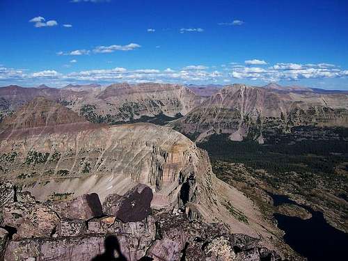 Looking east from Hayden's summit, "East Hayden" is the closest peak on the left. Ostler Peak is just to the right in the near background. Spread Eagle Peak is further right.
 Getting There
Christmas Meadows TrailheadTo get to the trailhead, drive east and north out of Kamas, or south of Evanston using Highway 150. The Christmas Meadows (gravel) Road leaves Highway 150 and heads SE from about .7 miles south of the Bear River Visitor Center and right at milepost 46. Follow the gravel road to the trailhead.
Hayden Pass/Highline Trailhead
The best trailhead for the hike is the Highline Trailhead located along State Highway 150 33.2 miles east and north of Kamas, or you could drive south from Evanston. You could also start at Mirror Lake, but you must pay to park there, and there isn't as much room to park.
 Spread Eagle Peak as seen from the ridge between Hayden and East Hayden Peaks, 8/20/2006.
Routes Overview
Naturalist BasinThis is the shortest and easiest route to the summit. The trailhead is at Hayden Pass. Naturalist Basin is a popular place to camp and fish and the trail to the basin is well used. From Naturalist Basin, the route heads north to the col between Mount Agassiz and Spread Eagle and then follows the ridge north east to the summit. The round trip distance is 18.6 miles and usually takes two days (see route page).
 Looking east from Mt. Agassiz towards Spread Eagle Peak.
Rock Creek
This is the premier route to Spread Eagle. The Trailhead is also at Hayden Pass. The route follows the Highline Trail over Rocky Sea Pass, then down into Rock Creek Basin berfore intersecting the Head of Rock Creek Trail and following it to Gladys Lake. From Gladys Lake, several routes are possible (see route page). The route is about 27 miles (depending on the variation) and usually takes three days.
 Spread Eagle as viewed from the east and Rock Creek in mid-August 1990.
Christmas Meadows
This route is more rugged than the other two. From the trailhead, the route follows the Stillwater Fork/Ryder Lake Trail to Middle Basin. From Middle Basin, the route climbs the rugged north ridge of Spread Eagle Peak (see route page). The round trip distance is 22.4 miles and usually takes 2-3 days.
 McPheters Lake with Ostler (left) and Spread Eagle Peak (right) as seen from middle basin, 8/20/2006
Red Tape
There is now a $3 per day use fee for parking along Highway 150. The area is in the High Uintas Wilderness Area and all the normal wilderness regulations apply.When To Climb
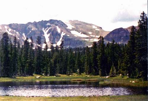
Highway 150 usually is plowed of snow sometime in June, but sometimes opens as early as Memorial Day or as late as July 4th. The road closes sometime in October, and always after November 1st. July through September is the normal hiking season. During this time, many, or most of the campgrounds are full. In winter, this would be a very long multi-day trip. Ostler and Spread Eagle Peaks on a frosty morning. September 5, 2004
Camping
Highway 150 has way too many campgrounds to list. All are crowded on summer weekends and holidays. Christmas Meadows also has a campground right near the trailhead.Backcountry campsites are plentiful. Naturalist Basin and Middle Basin/Stillwater Fork are fairly popular, but the Rock Creek Basin sees little camping use and offers solitude.
Mountain Conditions
Contact the ranger station in Kamas for current road and trail conditions. Their phone number is 801-783-4338.Weather Forecast for Central Uinta Mountains
Here are some average highs and lows from the 12,139 foot elevation (3700 meters) in the Uintas (about the same altitude as the summit):
| MONTH | HIGH | LOW |
| JAN | 14 | -1 |
| FEB | 16 | 1 |
| MAR | 19 | 4 |
| APR | 27 | 11 |
| MAY | 35 | 18 |
| JUN | 45 | 25 |
| JUL | 55 | 32 |
| AUG | 53 | 31 |
| SEP | 45 | 24 |
| OCT | 34 | 15 |
| NOV | 22 | 8 |
| DEC | 17 | 3 |