
-
 18520 Hits
-
 90.13% Score
-
 31 Votes
|
|
Mountain/Rock |
|---|---|
|
|
46.14581°N / 10.86119°E |
|
|
Trentino Alto Adige |
|
|
Mountaineering, Trad Climbing |
|
|
Summer |
|
|
10177 ft / 3102 m |
|
|
Overview
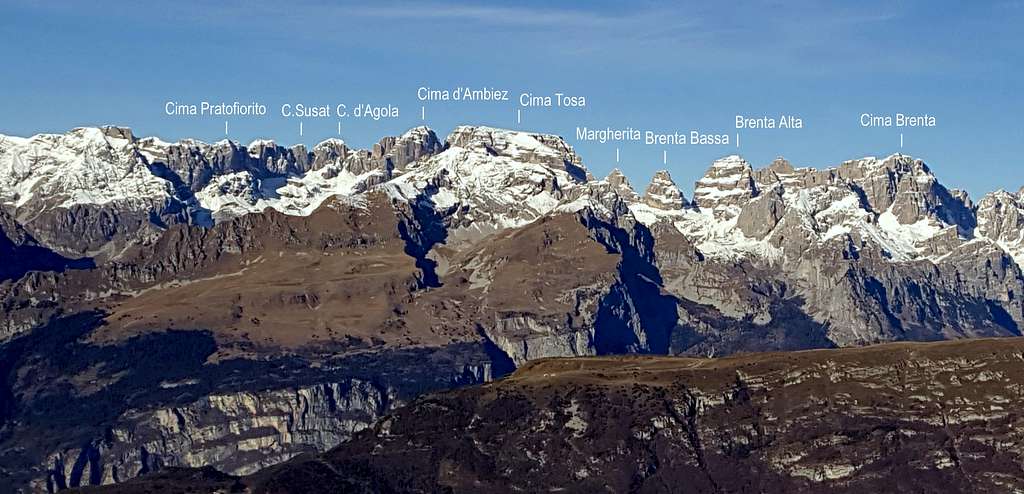
Geographical classification: Eastern Alps > Rhaetian-Alps > Brenta Group > Cima d'Ambiez
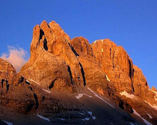
Cima d'Ambiez, the queen of the valley
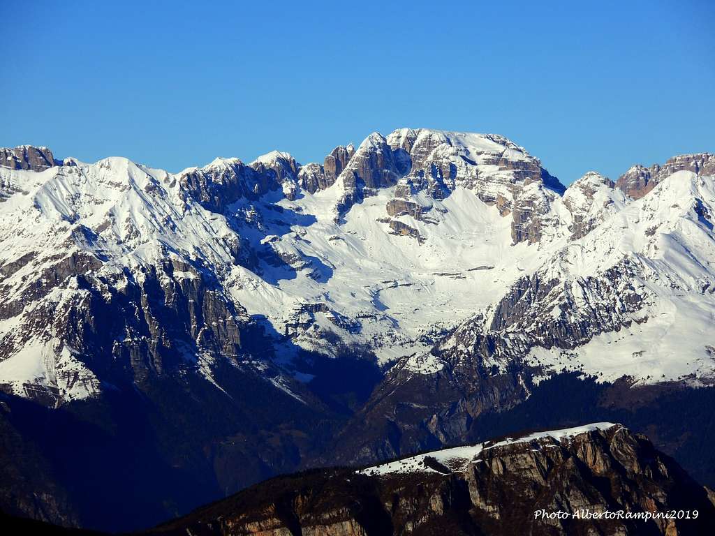
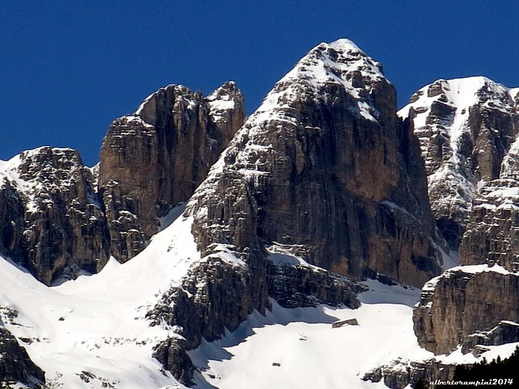
Cima d'Ambiez is a powerful summit overcoming the 3000 meters of altitude and lying in the Catena d'Ambiez, a chain coming off from the Tosa Massif nearby Bocca d'Ambiez and running almost straightly to the South for about 12 km, pushing itself in the direction of the Sarca Valley. Cima d'Ambiez is the most important peak of this branch and one of the main summits of the whole Brenta Group. As mentioned, to the North it's separated from the Tosa Massif by the deep saddle of Bocca d'Ambiez m. 2871, while to the South-West a narrow notch with two steep icy gullies divides it from the Cima Bassa d’Ambiez. Cima d’Ambiez is located at the head of the namesake valley, the Southernmost one of Brenta Dolomites, and stands out in reason of the magnificent and compact vertical East wall, site of numerous climbing routes on high quality rock and of high technical difficulty, that attract climbers from all over the world.
Cima d'Ambiez and Brenta Group seen from East (Cima La Rosta) - Ph. Silvia Mazzani
Cima d'Ambiez overlooks the upper part of Val d'Ambiez, beyond Rifugio Agostini, with this tremendous, regular and steep wall - built by a wonderful kind of grey and yellow "Dolomia Principale" - catching irresistibly the eye of the climbers. As told, plenty of stunning climbs on this natural jewel...The setting is superb and wild, less frequented that the central Brenta Group, in reason of the long approach (4 hours from the road). Notwithstanding this, it well deserves more than a visit without any doubts.
Getting There
Road access
The usual starting point to approach Cima d'Ambiez is San Lorenzo in Banale m. 729, a nice village in the southern end of Brenta Group. The main road access to San Lorenzo in Banale:
- Coming from A22 Brennero Motorway (direction towards South) exit Trento Centro, then follow the SS 45 towards Riva del Garda, getting to the village Le Sarche. From here take the SS 237 and after 11 km. turn to right towards Molveno and San Lorenzo in Banale (8 km. from the last junction).
- Coming from A22 Brennero Motorway (direction towards North) exit Rovereto Sud, then get to Arco. From here follow Valle del Sarca - route SS45 bis to Le Sarche. From here take the SS 237 and after 11 km. turn to right towards Molveno and San Lorenzo in Banale (8 km. from the last junction).

|

|
Approach to Silvio Agostini Hut in Val'Ambiez
From San Lorenzo in Banale m. 729 follow the Val d'Ambiez route to the "Ristoro Dolomiti" - Wide parking. Follow the narrow gravel road entering Val d'Ambiez, getting to Malga Prato di Sotto and Rifugio Cacciatore m. 1820 . Follow the path n. 325 rising quickly towards Rifugio Silvio Agostini m. 2410 - 4 hours by walking from San Lorenzo in Banale.
A Taxi service with off-road vehicles to Rifugio Cacciatore is available in the village of San Lorenzo in Banale.
History

|

|
The first summiters of Cima d'Ambiez were the German Gaskell, Holzmann and Kaufmann (1880, september, 5th) from Bocca dei Camosci on the West side. Now this route is rarely climbed in favour of the actual normal route on the South ridge, more pleasant and interesting. The first climbing route on the majestic and impressive East face was realized by Gabriel Haupt and Karl Lompel at the beginning of the Twentieth century (1909, july 26th).
Routes overview
Cima d'Ambiez routes overview
- South Ridge or Normal route UIAA II
An easy and pleasant climb on good rock, the best one to reach the summit with low difficulty; it's also the route commonly used to descent.
- North Ridge or Migotti route UIAA II
Another easy route starting from Bocca d'Ambiez, less frequented that the Normal one. Expecially climbed by the climbers who want to reach the Pedrotti Hut to climb also Cima Tosa.
Two interesting and amusing middle class routes are:
- NE dihedral - Castiglioni route UIAA III, 300m
This route can be climbed starting both from Rifugio Agostini (descending along the S ridge) and Rifugio Pedrotti alla Tosa (descending along the N ridge).
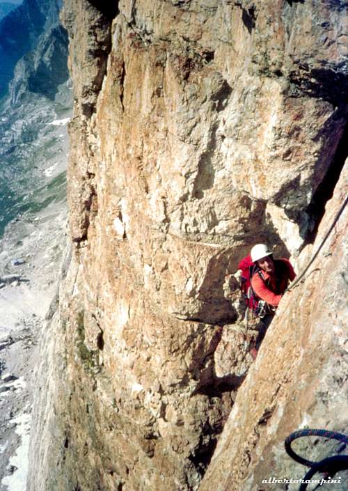
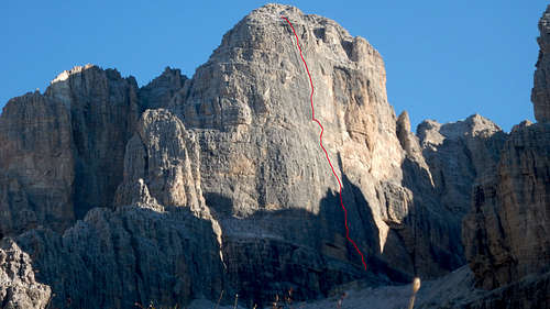
- Haupt-Lompel (East face) UIAA III, IV, 300 m.
East Wall
In the middle of East face - showing a huge roof - run the most challenging routes, while the right sector, facing North East, is less steep. The left hand side is cut by a long unmistakable crack, on which runs the great classic route of the whole peak, Fox-Stenico route. All the first class routes on the East wall from left to right:
- Patacorta UIAA IV, V, V+ 140 m.
- Ci piaccion tutte quante UIAA IV, V, V+ 200 m.
- Via dell'Ignazio UIAA V, V+, VII- 210 m.
- Bollicine UIAA V, VI, VII+ 210 m.
- Via Fox-Stenico UIAA V, V+, 300 m. The super classic route of the face
- Cent'anni UIAA V+, VI, VI+, VII- 320 m.
- Via Aste-Salice UIAA V, VI- 400 m.
- Via Vienna UIAA V+, VI 400 m. - Linea Nera V, VI 400 m.
- Sogno Libero V, V+, VI, VII, A0 400 m.
- Via della Soddisfazione UIAA V, VI 420 m.
- Magico Alverman UIAA V+, VI+ 420 m.
- Via Stenico-Girardi UIAA V, VI 450 m.
- Via della Concordia UIAA v+, VI+ 420 m.
- Il Regalo di Giac UIAA V+, VII, VIII 400 m.
- Positive Vibrazioni UIAA V, VI, VII, A2 400 m.
- Sul filo della fantasia UIAA V+, VI, VII, VIII, A3 300 m. - F. Giacomelli, E. Orlandi summer 2015
- Via degli Strapiombi UIAA V, VI, A2, A3 410 m.
- In punta di piedi UIAA V+, VI, VII, VII, A2 410 m.
- Perlage UIAA VI, VII, A3 410 m.
- Senso di vuoto UIAA V+, VI, VII+, A2 410 m.
- Via Barbier-Masè UIAA V+, VI, VII+ 410 m.
- Il sogno di Michael UIAA V+, VI, VII 410 m.
- Via San Marco UIAA V, VI, A2 410 m.
- Via Angele UIAA IV, V+, VII+ or A0 (1 move) 410 m. - Elio Orlandi, summer 2011
- Via del Gran Camino Nord UIAA IV, V+ 380 m.
- Cavallo Pazzo UIAA V, V+ 200 m.
- Haupt-Lompel UIAA III+, IV- 450 m.
- North-East Ridge UIAA III, IV 330 m.

|
|
Descent: the best way to descent from the summit is downclimb along the South ridge. From the summit follow the ridge facing South, then the cairns along a system of ledges and footholds, ending over an almost vertical, but easy, wall. Downclimb it on the right - facing out - or alternatevely do two abseils, getting the notch between Cima d'Ambiez and Denti d'Ambiez. An anchors in the notch, on a big stone, allows another 50 m. abseil to the bottom of a gully. From here downclimb some easy rocks (UIAA II), or do another 30 m. abseil, getting to the ledge cutting the base of East wall. Follow it to reach the path and Agostini Hut.
When To Climb
Best period goes from late June to the middle of September
Red Tape

|

|
No fees no permits required. Cima d'Ambiez is located in "Brenta Dolomites", the Westernmost area of the nine areas of the Dolomites admitted in the year 2009 in the list of UNESCO WORLD HERITAGE SITES. More info about Dolomiti Unesco World Heritage here:
- in the article by Silvia Mazzani: Dolomites living mountains
- on the Unesco Official web-site: Unesco
- on the Fondazione Dolomiti Unesco web-site: Fondazione Dolomiti Unesco
Huts and bivouacs
- Rifugio Silvio Agostini 2410 m - S.A.T. (Società Alpinisti Tridentini) Trento
- Size: 57 beds
- Open: from june, 20th to September 30th
- Winter shelter: always open (8 beds)
- Phone +390465734138 Mobil Phone +393487152589

|

|
Meteo

Guidebooks and maps
"Dolomiti di Brenta" by Gino Buscaini and Ettore Castiglioni - Collana Guide dei Monti d'Italia, CAI TCI
"Dolomiti di Brenta - Val d'Ambiez" Vol. I by Francesco Cappellari and Elio Orlandi - Idea Montagna Editoria e Alpinismo
 |
 |