
|
|
Mountain/Rock |
|---|---|
|
|
39.58500°N / 115.819°W |
|
|
10614 ft / 3235 m |
|
|
Overview
Diamond Peak is the highest point in the Diamond Range, near the boom-and-bust community of Eureka, Nevada. At 10,614', it towers above many miles of US Highway 50, the "Loneliest road in America". As Great Basin peaks go, this one is fairly easy to get, and is not far from civilization.
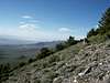
Routes to the summit are straightforward and direct class 2 scrambles. All approaches offer the typical unrestricted vistas that are classic in "Basin & Range" topography. Because this peak gets only a handful of visitors a year, don't expect to see anyone up there (unless you meet the occasional rancher, scientist, hunter, or Federal land agency employee). There is (or at least used to be) an interesting mailbox with a street-type sign at the summit that serves as a summit can --- an indicator that at least a few locals make it up now and again.
Along the way one can see groves of limber pine, a tree only seen in the high-altitude regions of the Great Basin. While this species is capable of growing quite old, many of the trees in this area were cut during days of intense mining activity, and thus older specimens on Diamond Peak are few and far between.
 |  |  |
Getting to the Middle of Nowhere
The starting point for all climbs is usually the town of Eureka, right on US 50. Here you can get some decent chow, fill up with gas, and stay the night (rates start around $30). The town is approximately 130 miles west of Great Basin National Park; 370 miles east of Reno; 100 miles south of Elko, Nevada; and 170 miles north of Tonopah, Nevada. From Eureka the mountain can be approached from the east, south, or west. Most of the dirt roads along the east side end in "private property" gates as there are many ranchers and residents living along the slopes of Diamond Valley. The more isolated approaches are on the west, from Newark Valley. The climbs from both sides would be steep and long, involving a lot of elevation. Thus, the mountain is usually approached from the south via Newark Summit.
These driving directions to Newark Summit are from a report by Ken Jones on a County Highpoints website:
"At the north end of Eureka, there is a paved road branching off US 50 with a sign indicating "dump." Turn onto this paved road and reset your odometer. At 1.3 miles, turn right (still paved), again following landfill signs. At 1.7 miles the landfill is a right turn, but you will continue straight ahead onto a gravel road. At 3.7 miles, bear right, staying on the main road. At 4.6 miles keep left - the right fork (which is a better road) heads onto Baumann's Ranch. At 5.3 miles keep left at a minor junction. At 8.9 miles, just before the main road reaches its highest point, turn left onto a high clearance, 4WD road. At 10.7 miles from US 50 bear left at a minor fork and gate toward and past Poison Spring. Follow this road up over a saddle and down, then up, to the stock tank at 11.0 miles from US 50."
 |
Red Tape
There are no fees, restrictions, closures, or rules that I am aware of. Climbers should take into account the fall deer-hunting seasons --- don't dress like a deer, and expect to see people if you go during these times.
When To Climb
The comparatively mild snow conditions of the Great Basin offer an extended dayhiking season for those who don't like to gear up for major winter alpine adventures. Winter climbs should be done with waterproof boots and possibly gaiters if there is any snow. Summer hikes should always involve lots of water, as the evaporation rates get quite high in the desert. This hike is so short that this is not a major concern unless you are doing it from the valley floor. Times of high snow accumulation and/or muddy conditions would hamper driving efforts on the dirt road sections.
Camping
Camping is available literally all over the place. There are no fees for camping on BLM or general USFS land. Stay off the private, and you will be fine!
Mountain Conditions
Like most Great Basin peaks, this one requires creative research and a lot of guessing to determine current conditions!
famartin1 - Oct 24, 2014 3:04 am - Hasn't voted
mostly stay left (west)Sumitted on 10/3/2014. From the stock tank, going up to the ridgeline, while I followed the trail on the right side of the first peak both coming and going, generally I found it was wisest to stay left of the following ridge bumps until reaching the main upgrade to the summit. i did that going up, but tried the other side (east side) coming back down and was not pleased with the results; a lot of side hilling on lose terrain with not much in the way of a trail that I could find.