

-
 16718 Hits
-
 85.36% Score
-
 20 Votes
|
|
Mountain/Rock |
|---|---|
|
|
46.67560°N / 12.52420°E |
|
|
8822 ft / 2689 m |
|
|
Overview
 Königswand from the SE Königswand from the SE |
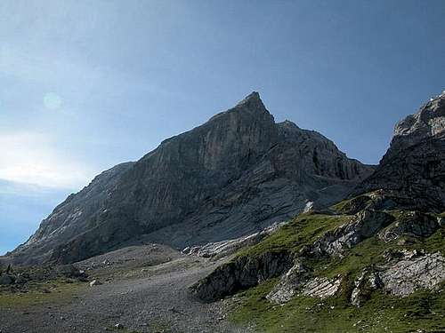
Grosse Kinigat (2689m) is the highest summit of a trinity of peaks in the Carnic Alps Main Ridge. Together with its namesake Kleine Kinigat (2671m) and Königswand (2686m) it is the westernmost of the Dolomite-like limestone cliffs of the ridge, and also the highest summit in the main ridge west of Monte Peralba. In Italian Literature both Königswand and Grosse Kinigat are treated as one mountain, Monte Cavallino, due to their closeness.
From a climbing point of view Grosse Kinigat as well as Königswand are arguably the most important mountains of the Carnic Alps Main Ridge. Some 20 routes run along their walls, many of them in very good conditions. To the north of the mountain there is another limestone cliff, Liköflwand, which also is a good climbing spot with lots of short (150 - 200m) routes. To the south of the group there is the beautiful Königswandtürml, a tower which could hold its own against any of the towers of the Dolomites.
 Grosse Kinigat / M. Cavallino and Kleine Kinigat / M. Cavalatto, from the north
You might have read this before but the main ridge was the frontline during the First World War. Here between the two Kinigats Austrian troops held their positions in the saddle called Sandiger Boden / Forcella Piani di Sabbia. Like elsewhere in the Carnic Alps the supply trails have been turned into hiking trails and in the case of Grosse Kinigat two ferrate have been created which reach the top. The southern one is short and easy, but quite slippery even in dry conditions. The limestone has been polished to resemble marble and on a wet day it can be difficult to keep your balance. The western ferrata climbs the west face from Sandiger Boden / Forcella Piani di Sabbia. Due to fixed cables it is also rather easy to climb but take care of the scree! The trail is very steep and you won't be able to keep pebbles from falling. I almost got rid of my girlfriend by breaking a stone lose.
 From Filmoor saddle
In comparison to neighbouring Kleine Kinigat this summit is quite popular. You won't find the usual tourons up at the top - the ferrate will take care of those. Still everybody with a little climbing experience will go for the summit, if only to enjoy the views. These are magnificent, especially the western one were you can see the long line of the Sexten Dolomites east faces. And the close-up views of Kleine Kinigat and Königswand are breathtaking as well.
 From the S
The first summit ascent was recorded on July 21st, 1898 by A. Victorin and P. Egger. On that very day they climbed also on top of Königswand.
Summit Views
 Towards Lienz Dolomites
Though Grosse Kinigat is known best for its climbing routes it certainly also is a perfect lookout peak.
The main Carnic Alps ridge is a mountain world near the famous geological fault - Periadriatic Fault. So, the mountains on the south and north are very different. On the south our eyes are cheered by wild towered mountains of Dolomites and of those Carnic Alps groups which resemble Dolomites. The Sexten Dolomites are very close and well seen. On the northern side are beyond Lesachtal first a bit lower outposts of Lienz Dolomites, which in this part are not so high to obscure the view on the glaciated main summits of Hohe Tauern. And along the Carnic Alps main crest the kulisses of Carnic Alps are following one another.
 The view towards the E The view towards the E |
 Dreischusterspitze / Tre Scarperi Dreischusterspitze / Tre Scarperi |
 Kleine Kinigat / Monte Cavalatto Kleine Kinigat / Monte Cavalatto |
Geographical Overview
 Likoefelwand
Actually Grosse Kinigat / Monte Cavallino reigns a small mountain group. To the NW of it there is Kleine Kinigat / Monte Cavalato, 2671 m. Towards the SE and even closer, the summit ridge is connecting Grosse Kinigat with Königswand, 2686 m. And from the southern face of Königswand a bold tower named Königswandtürml is rising. To the north of the group there is a broad Liköfelwand, 2421 m, which is also an attractive goal. Between Liköfelwand and the main ridge there is the Tscharre valley, ending with Hintersattel, 2406 m, the saddle, where Liköfelwand is being connected on the main ridge. On the SE the group ends with Filmoorsattel, 2453, beyond which the main Carnic Alps ridge continues on Filmoorhöhe. West of Kleine Kinigat / Monte Cavalatto the main ridge changes geologically, but continues without much height loss on the summit of Pfannspitze / Cima Vanscuro, which does not belong to our group any more.
Towards the south the walls of our group are at first falling very steeply, then broad scree fields are lowering down towards the meadows, which are forming the end of La Silvella pastures, that one representing the end of Digon creek valley. And towards the north of our group long valleys and ridges are descending towards Lesachtal and Tiroler Gailtal. Between both these valleys there's Kartitscher Sattel, 1525 m.
Getting There
 The western part of the Carnic Alps Main Ridge. The numbers refer to the respective subgroups as given on the Carnic Alps Main Ridge (West) Page. Grosse Kinigat is located to the west of subgroup 2.
On the north, the best trailhead for Grosse Kinigat / Monte Cavallino is the village of Kartitsch in the Tyrol Gailtal Valley. Other trailheads are in Lesachtal. The southern approaches go from Comelico Superiore area, the place, where in Campitello from the north Torrente Digon comes in the main valley.
Driving to the northern side
We must reach B111, the main road running through the Tyrol Gailtal and Lesachtal Valleys. So Kartitsch, Erschbaum and Leiten can be reached as follows:From the West (Brenner Motorway A22): Leave the Brenner Motorway near Brixen / Bressanone and follow SS49 to the east through Pustertal / Val Pusteria. To the east of Innichen / San Candido you cross the Austrian-Italian border and follow the road (now B100) to Tassenbach. Turn right (south-east) here onto B111, which you follow in direction Kartitsch. In Kartitsch at the grocery store turn right into the village and follow the signs to the sports field.
From the North: There are two possible roads:
From the South (Udine): Take Motorway A23 to the exit Carnia Tolmezzo. Follow SS52 north to Tolmezzo where you turn onto SS52 bis. This leads to Plöckenpass, where it crosses the Austrian-Italian border. In Austria the road turns into B100 and at Kötschach-Mauthen you have to turn east on B111 into Lesachtal Valley. Again, go on through the whole valley to Kartitsch.
Northern trailheads
1. From Kartitsch. In the town you deter S and drive some 100 m to the sport place on cca 1400 m. There is the trailhead for the approach via Obstanser See. For Grosser Kinigat this means the approach by the W ridge.
2. From Erschbaum or. Sulzenbach through Erschbaumer Tal. We park in one of the villages.
3. From Leiten or. from the Kartitsch saddle through Schöntal. We park in the village or on the saddle.
4. From Leiten through Leitental. We park in the village.
Coming from the south
By the valley of Piave river drive towards the north, towards Monte Croce Comelico / Kreuzberg pass. Above Campitello, by a big left road turn deter from the main road towards the right and continue northwards into Val Digon. At the end, the valley turn towards the NW. You can leave your car on the crossroads, where one mountain road continues northwards on Casera Formaggio, and the other mountain road goes by the valley further to Casera di Silvella. Or, you can drive towards the latter. From both alpine meadows, which are on approximately the same altitude, marked trails go on Forcella Cavallino/Filmoorsattel.
Summit Ascent Routes Overview
 Summit cross
From the north, there is no easy ascent on Grosse Kinigat / Monte Cavallino. Also on Sandiger Boden / Forcella Piani di Sabbia, so on the saddle between Kleine and Grosse Kinigat, it seems we can not reach easilly from the north (How did they supply it during the World War I?). Through any of the valleys we shall need to the summit ascent routes some 3 to 4 hours. We must reach Filmoorsattel / Forcella Cavallino, 2453 m, on the SE of the group. From there, the southern, Italian approach on top goes.
If we are coming from the west, so through Winkler Tal and by Obstanser See Hütte, the shortest ascent on Grosse Kinigat / Monte Cavallino is by the ridge path, which goes over Pfannspitze / Cima Vanscuro. We need 3 hours to the hut and then 1 more hour on Pfannspitze and 45 minutes more to Sandiger Boden / Forcella Piani di Sabbia.
Coming from Austria, we can of course reach this saddle also by the southern side - but that is even a longer detour.
If we are coming from the Italian side, we have from the above mentioned alpine pastures only good one hour to Filmoorsattel / Forcella Cavallino.
So now we are on the main ridge. Now let's describe only both two routes on top.
 In the ferrata
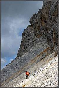 S ferrata approach
South ferata
From Filmoorsattel / Forcella Cavallino we go by a comfortable path across big scree fields below the S walls. The long distance trek path goes a bit lower, but we can go also by a path, which crosses some 50 meters higher, more close to the walls. We first pass Königswandtürml and then approach a well visible ramp, which cuts the S walls left upwards. It looks steep, but the route is not hard (Austrian grade B for ferrate), all the time we have a good cable to help. This is the approach which is also in winter and spring much in use. The rocks are polished, we can spot nice pieces of marble. After 100 m of ascent the route exits on the summit plateau, we turn right and reach the big summit cross in a few minutes. 45 min from the saddle. In the West route
West Route
Also this route originates from the World War 1. From Sandiger Boden / Forcella Piani di Sabbia we go first a bit to the left and then soon enter the rocks. The short wall is quite crumbly, and also here we are climbing over nice marble rocks. One has a feeling like climbing on a nice cathedral.After good 100 m the ferrata ends, the slope gets less inclined and by the northern side of the ridge we are approaching the summit. Here a small summit plateau is formed, also on it we can spot many remains from the WW1. We pass the exit of the South ferrata and over the summit rocks we reach the top. Good 30 minutes from Sandiger Boden / Forcella Piani di Sabbia. This route is only a bit harder than the South ferrata.
Map: Tabacco No. 017: Dolomiti di Auronzo e del Comelico . 1:25000.
Climbing Grosse Kinigat
 Northern walls
As I have done elsewhere I will only include the abstracts of the climbs here. Complete descriptions can be found in the German Alpine Club Guidebook (German): P.Holl: Karnischer Hauptkamm, Rother Verlag, ISBN: 3-7633-1254-4.
- South Flank Ferrata
Rated: I
see corresponding route
- Southern Chimney
Rated: IV-
Length: 90m
- West Flank War Trail
Rated: I (war trail turned ferrata)
see corresponding route
- North Ridge
Rated: IV
First Climbed: 1925 (Rudovsky, Hitzker, Valentin)
Length: 500m
- North-East Face, “Plattenweg”
Rated: V+, A1
First Climbed: 1980 (Sint, Sint)
Length: 500m
- North-East Face, “Silberplatte”
Rated: VI-, A0
First Climbed: 1986 (Sint, Meysel)
Length: 500m
- North-East Face, “Supersilberplatte”
Rated: VI+
First Climbed: 1986 (Sint, Strasser, Goller)
Length: 500m
- North-East Face, “Weg durch die Höhle”
Rated: III
First Climbed: 1981 (Goller, Goller, Goller)
Length: 400m
- North-East Face Chimney
Rated: IV
First Climbed: 1982 (Goller, Goller)
Length: 150m
- North-East Face
Rated: III
First Climbed: 1918 by Austrian Soldiers
Length: 400m
Climbing Königswand
 Koenigswand from the SE
Königswand is a rock which almost reaches the same height as Grosse Kinigat. It is located to its east and separated by a small saddle. The most common ascent route leads across this saddle from Grosse Kinigat.
- East Ridge Southern Flank and Upper East Ridge
Rated: III (VERY LOOSE)
First Climbed: 1898 (Victorin, Tassenbacher)
Length: 200m
- Complete East Ridge
Rated: II
Length: 250m
- Ridge Traverse from Grosse Kinigat
Rated: II
First Climbed: 1898 (Victorin, Tassenbacher)
Length of the ridge: 200m
- Königswandscharte from the south
Rated: I
- Königswandscharte, North-Eastern Gully
Rated: III
Length: 400m
- North-East Face, Rudovskyweg
Rated: III
First climbed during WW I
Length: 300m
- North-East Face, direct entry
Rated: III
Length: 120m
- North-East Face, direct exit
Rated: IV-
First climbed: 1985 (Strasser, Goller, Sommer)
Length: 150m
- North-East Face Diagonal
Rated: III
First climbed: 1985 (Goller, Goller, Sommer)
Length: 250m
- North-East Face, “Ausflug im Nebel”
Rated: III
First climbed: 1986 (Strasser, Goller, Sommer)
Length: 150m
- North-East Face, Right Route
Rated: IV
First climbed: 1985 (Strasser, Goller, Sommer)
Length: 300m
- North-East Face, “Teufelsrinne”
Rated: V-, A0
First climbed: 1975 (Goller, Goller, Sommer)
Length: 150m
- South Face
Rated: III
First climbed: 1954 (Wiegele, Zojer)
Length: 150m
- South Face, “Neuer Weg”
Rated: III
First climbed: 1977 (Tabernig, Thurner)
Length: 150m
Climbing Königswandtürml
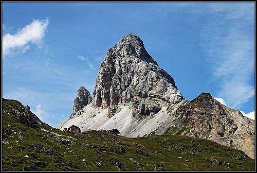
 Koenigswandtuerml
Königswandtürml is a tower, which is located to the south of the Königswand – Grosse Kinigat Group, roughly in between the two summits. There are a few beautiful classical routes:
- Northern Flank (from the ridge towards Königswand)
Rated: II
First climbed: 1964 (Zojer, Wiegele)
Length: 50m
- North Spur and North Face
Rated: III
First climbed: 1965 (Zojer, Wiegele)
Length: 100m
- East Face
Rated: IV-
First climbed: 1974 (Sepperer, Unterluggauer, Wiegele)
Length: 100m
 |  |  |  |
Red Tape
 |  |  |
There is no Red Tape here. However, the mountain is located on the border between Austria and Italy so have your ID ready and don't try to camp out. Go to Filmoor Stanschützenhütte or Obstanser Seehütte for overnight accommodation. The proprietors will surely turn a blind eye on your camping outside.
When To Climb
The hiking and climbing season is June through September. On the web I have seen pictures of a ski tour ascent in winter though I wonder how they might have done it.Accommodation and Mountain Huts
 Good beer supplies at Filmoor hut.
As said above camping on the border is discouraged. Stay at the refuges (see here) or at one of the little campgrounds in Lesachtal Valley. The latter are mostly associated with an inn or hotel. If you are looking for hotel rooms or apartments follow one of the links below
Mountain Huts
Obstanser See Hütte, 2304 m. Can be reached from Kartitsch in 3 h (2 h if we take a hut taxi till the end of Winkel Tal). 60 places, opened from mid June till the end of September. Tel: +43(4848)5422, +43(0664)1618723. E-mail: bhp@tirolspeed.com.Filmoor Standschützenhütte, 2350 m. Can be reached through Erschbaumertal, trail No. 465, in 4 h, or through Schöntal, trail No. 464, in 3 h 30 min. Tel: +43-664-1127153 (only text messages).
Weather Conditions
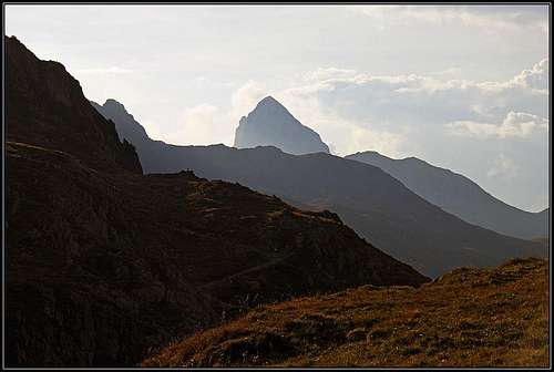 Evening mood - Grosse Kinigat, seen from the east
We can climb Grosse Kinigat / Monte Cavallino any time of the season. In hard winter or when there's ice on rocks, we shall need a full winter equipment. Otherwise the tour is not hard. We can best recommend an ascent which is part of a whole day-stage of the long distance Carnic Alps trek. Choose time when visibility is good.
In the times of tour skiing the whole area is great for ski tours. The ascent on Grosse Kinigat / Monte Cavallino however must be done on the top part only on foot. We usually leave skis below the South wall ferrata.
In general the weather in south-eastern Austria is much better than in the northern and western parts of the country. Still, the Carnic Alps Main ridge is a weather divide in northern or southern wind conditions so it pays to keep informed. Look at one of the links below or (even better) call the proprietors of the huts. You'll find all phone numbers on the Carnic Alps Main Page.
- Tyrol weather
- South Tyrol weather (for the English text you have to scroll down the right frame)
Maps 'n' Books
MapsI have been using maps by Kompass Verlag, which are very good for the hiking trails though they don't show ALL the relevant summits of the area.
- Lienzer Dolomiten / Lesachtal
1:50000
Kompass Map WK47
Kompass Verlag
ISBN: 3-85491-053-3
- Tabacco Map 10: Sesto
1:25000
As for books please look at the appropriate section of the Carnic Alps page.