
|
|
Route |
|---|---|
|
|
39.35140°N / 106.1108°W |
|
|
Ice Climbs |
|
|
Half a day |
|
|
Up to WI5 |
|
|
Introduction
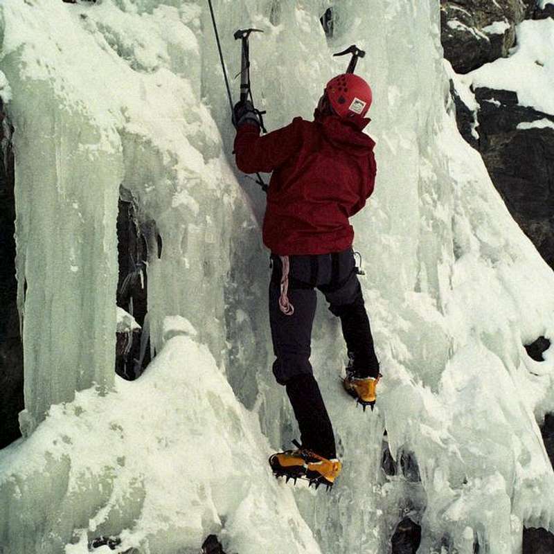
As the main page of this forum states, this page is for seriously dysfunctional individuals that enjoy hanging around in sub-zero temperatures from medieval looking tools on solid ice. Read on if you would like to explore ice climbing on the popular Colorado Fourteener, Mount Lincoln.
I intend this route page for the Mount Lincoln Icefall as a work in progress. Please email me with any additional routes, corrections, or tips. Also, please add your own photos. My overall area photo is pretty dark, and it would be nice to have a better one to replace it.
Feedback is much appreciated. I've climbed all the routes that I know of in the area, but I know there are some more variations. For example, I know of a Mixed route near the center flow, but I haven't done it, and couldn't explain it.
Thanks for any help!
Lincoln Ice!
Lincoln Icefall Overview
The northeast face of Mount Lincoln has a nice icefall that offers some great climbing in a beautiful location. The routes here range from WI 2 to WI 5, with a few mixed options if you are really creative and bold. Mount Lincoln is the 8th highest mountain in Colorado, and is seen by countless tourists each year as they drive on CO 9 over Hoosier pass. The summit of Hoosier pass has a lookout point that offers a great view of Mount Lincoln and its neighbor, Mount Bross.
To find summit routes for Mount Lincoln, please visit the main Mount Lincoln Page, maintained by kilimanjaro1.
There are three main flows at Lincoln. All are close to the others. The one great thing that Lincoln offers is the ability to top rope most of the ice here with walk-around access to bolts drilled in boulders above the pitches. It's a great learning area because of this access.
Recently, someone diverted a small stream with a hose to feed the icefall in winter, and now the ice comes in fat and stays longer than it did historically. The altitude is also pretty high, so it stays cold here longer than Vail or RMNP. You can climb a long season at Lincoln.
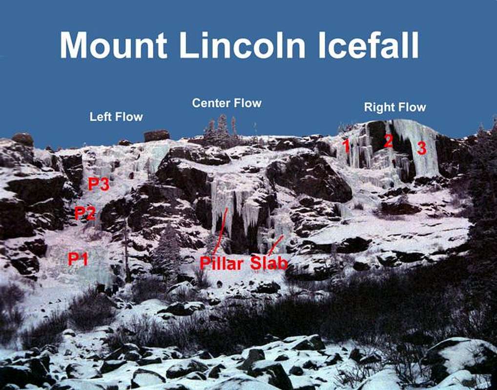
This photo shows the three main flows at Lincoln. Refer to this photo when reading the explanations below.
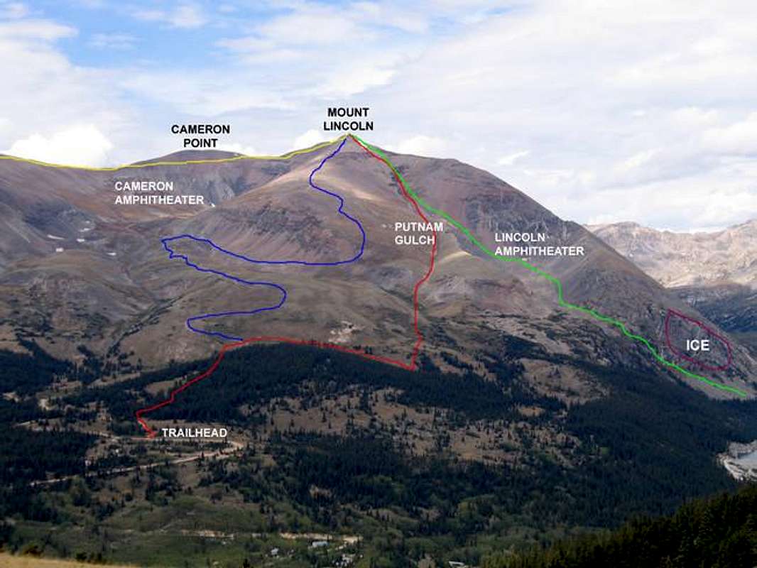
Route Photo for Mount Lincoln. The ice climbing area is outlined in purple
 |
Approach
The trailhead for this icefall is near the Montgomery Reservoir, south of Hoosier Pass and north of the small town of Alma.
From the South:
Go 10.7 miles north on CO 9 from the CO 9 - US 285 junction in Fairplay.
From the North:
Go 1.1 miles south of the summit of Hoosier Pass on CO 9.
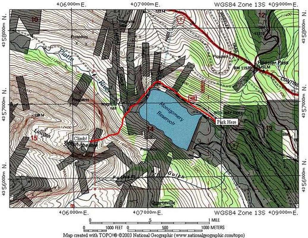
Turn west onto Park County 4. There are two entrances to PC 4 - you want the northernmost one. Use the mileages above to be sure. Proceed down the hill past some homes, keep right at 0.8 miles, keep right again at 1.0 mile and go up the steep hill. You will pass an open gate, and soon see a parking area. Park before you go around the reservoir. A few years ago, you could drive around the reservoir and park near the Magnolia Mine, but now you must park on the far side and walk the gated road.
This road keeps heavy snow because it is shaded. You might need a 4x4 vehicle to access the parking area after a big dump.
After parking, walk the rest of the road to the Magnolia Mine, but stay away from private property. NEVER WALK ON THE RESERVOIR! It provides drinking water and never fully freezes over.
From the mine, proceed straight up through the forest on what is probably a well-worn trail in the snow. You will soon come to a large boulder field from rockfall and avalanche debris. Wind through the boulder field to the base of the climbs. Take special care here not to punch a leg through as you cross the boulders. When you come to the boulder field, the icefall will be obvious above you.
The approach is about 1.5 miles and gains about 1000 feet of altitude. It's quite a warm-up, and will take longer than you think. I got caught walking out in the dark this winter because we did the "one more pitch" thing, and dusk came faster than we thought. It's slow-going through the boulders, and you don't want to get stuck doing it in the dark (like I did.) Always carry a light!
Refer to the TOPO! map below for this approach route.
Or use this link if you prefer a Topozone map:
Topozone Map:
Mount Lincoln Icefall
Left Flow - "Scottish Gully"
The left flow (as you look up at the icefall) has three distinct pitches when the ice is in fat. This is a great spot to learn, or a great "first lead." It's commonly known as the Scottish Gully, but on this page, I'm going to stick to easy "left, right, center" designations to avoid confusion. I'll add names when appropriate.
Pitch One
Referring to the photo above of the whole area, this is the lowest ice on the mountain, in the left foreground. It goes at WI 2- WI 3, depending on your specific line. Use screws or top rope on the many trees on the right side of the ice.
Pitch Two
This pitch joins Pitch One and the more difficult Pitch Three. It's pretty low-angled, and can be climbed free. If you desire a belay, use trees on your right. This will not exceed WI 2.
Pitch Three
This is the most difficult pitch on the left flow. It will go at WI 3 - WI 4 depeding on the ice that year and your line. From a belay stance atop Pitch Two, climb directly up the flow to a car-sized boulder on top of the flow. There are bolts here that are drilled into the rock. These bolts can be accessed from hiking around all the ice to the top. This is a great top rope spot.
It is possible to go straight to Pitch Three. Hike around to the boulders on top, and set a toprope anchor. From below the center flow, where the approach hike takes you, traverse onto the middle of Pitch Two and free climb to the base of Pitch 3. Climb away!
 |  |
Center Flow - Pillar and Easy Slab
The Center Flow is directly above your approach hike, and is the first place you will come to after you pass the boulder field. There are two main lines here, a pillar on your left and an easier slab on your right.
The Pillar
This is the obvious hanging ice pillar on the photo above in the center. It's one pitch and goes at WI 4 - WI 5. Start on the hanging ice and pull onto the slab above. Belay at bolts in the rock above. This is top rope accessible by hiking around.
Easy Slab
To the right of the pillar is a slab that goes up to the same anchor as the chandelier. The beginning is the most difficult spot. This goes at WI 2 - WI 3. This can be top roped with a good directional off of rock or a tree.
 |  |  |  |
Right Flow
There are three lines on the right flow at Lincoln Icefall. They are all visible in the above photo. From right to left, they are The Low Angle Slab, A hanging flow called Sickle on a Stick, and The Main Flow. All these routes can be TR'ed from bolts with chains at the top. 20-30 feet of webbing might be nice for a toprope because the bolts are set back from the top of the ice.
Low Angle Slab (#1 in photo above)
This slab goes at WI 2- WI 3 and is the leftmost line on the right flow. It's a pretty easy line to follow. It can be toproped from the top from bolts with chains. A directional might be nice.
Sickle on a Stick (#2 in photo above)
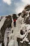
This line is probably the toughest climb at the Lincoln Icefall, and is often not climbable. It is the thin ice pillar in the center of the right flow. It's a solid WI 5, and a very dicey lead. One pitch, and can be toproped from the top at bolts with chains.
Main Flow, Right (#3 in photo above)
This is the largest flow in the area. It goes at WI 4, and is one pitch. Use the aforementioned bolts for a TR. This is a nice, wide WI 4.
I don't have any digital photos of these routes (except for the overall photo). Please add some if you have them.
More Ice at Lincoln
SP member mconnell submitted the following information:
There is some lower angle ice (WI2-3?) off to the left of your area photo. We didn't have time to climb on it last time I was there so I don't have any specifics. From the very bottom left of your photo, you can cross about 50 ft through trees to the area I'm talking about. I don't know if it is there always, but it was fat 3 weeks ago.
Also:
If someone wanted to practice some easier mixed climbing on top rope, you could set up a top rope from the boulder on the skyline at the very left side of the area photo and climb a short, mixed climb there. It is basically on the left wall of the gulley and is not really visible in the photo.
If anyone has info on these areas, or photos, please submit them as additional information, and I will incorporate them into the main text. Thanks.
Essential Gear
Essential gear is standard ice climbing gear - ice tools, ice boots, pro, ropes, crampons, etc.
Most of the routes here are top-ropeable, so you can forgo screws if you don't want to lead. Most of the routes can be done with a 60m rope to descend. I would bring two 60m ropes if you intend to rap any of the routes in their entirety. There are many places here to sling trees at good stances, so one rope will do fine in most cases. Also, you can walk off almost every route here.
You might want some trekking poles for the approach and walk back to the car. It's a tough hike. It might also be worth bringing some hiking boots to ease the approach, if you don't mind packing your ice boots.
Weather and Avalanche Information
NOAA Weather Link for Mount Lincoln Area.
CAIC Link for Mount Lincoln Area. The Lincoln Amphitheather (which you will be climbing under) is a known, large slide path. Carefully consider when you choose to climb here. The large boulder field below you full of debris should make you think...
Where to Stay
The closest town to stay in would be Breckenridge, which is just over the other side of Hoosier Pass. The popular ski resort has many places to stay. Visit this link to find lodging there.
Camping could be possible here as long as you are not on the private property of the Magnolia Mine.