
|
|
Route |
|---|---|
|
|
41.19980°N / 111.88209°W |
|
|
Hiking |
|
|
Spring, Summer, Fall |
|
|
Half a day |
|
|
Moderate Hiking |
|
|
I |
|
|
Overview
 Rocks along Route
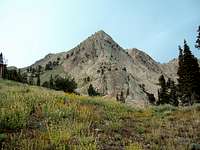 Mt Ogden from the Trail
Snow Basin Trailhead starts at 6,350 feet and the Mt Ogden summit is 9,572 feet high. Total elevation gain for this route is 3,222 feet.
The route is part of the Great Western Trail System. Should you opt to not return to the Snow Basin, the trail continues down the west side of the mountain thru Beus Canyon (6.1 miles) to 46th Street Ogden. You can also go down Malan Basin/Waterfall Canyon to 29th Street in Ogden (also about 6 miles).
During winter the route is closed for obvious reasons (it’s a ski resort!), but can be hiked after the resort closes in the spring until it reopens in the late fall. For early/late season hikes, you can expect most of the trail to be covered in snow. Snow patches on the upper trail/traverse may be present from October into July.
Route Description
 Route winds under Ski Lifts
 Fork on Service Road near Wildcat
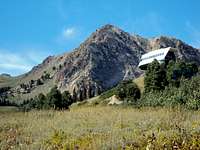
The only place you can possibly get on the wrong road is at the top of the Wildcat Ski Lift (41.200356,-111.866022). At this point, the road forks left and right. The left fork continues toward Needles Lodge. Take the right fork as it goes downhill a little ways before going toward Mt Ogden.
At Wildcat, Mt Ogden is right in front of you, but its close appearance is deceptive. You still have about a mile or so before reaching the Saddle. Once on the Saddle, you can see Ogden City to the West and you will be standing immediately below Mt Ogden. Everything looks really obvious at this point. The service road goes sharply north up the mountain. Keep your eyes open for a small sign “trail to Mt Ogden”. The last 50 yards is a very rocky trail up to the helipad. The best way to climb up on the helipad is from the north.
An alternate route to this route (for under motivated hikers) is to pay the $14 and take the Snow Basin gondola up to Needles Lodge from the resort parking lot. From Needles, follow the service road to Wildcat Ski Lift, take the left fork and follow the road to Mt. Ogden. The Gondola will take you to 8,600 feet, cutting 2,250 feet of elevation gain and about 2.25 miles off the hike. Taking the Gondola is popular with tourists as there is a restaurant at Needles Lodge and about ½ of the remaining 2 miles is relatively flat (but there’s still a 900 foot gain!). The Gondola runs during summer months but does close for lightening storms.
Getting There
 Gondola Station at Trailhead
The Trailhead is located at 41.218307,-111.86275.
From Interstate 15, turn onto I-84E, drive 11.7 miles and take Exit 92 to Mountain Green/Huntsville. Drive .2 miles to UT-167 (North Trappers Loop Road) and follow the UT-167 for 5.5 miles. You’ll see the turn to Snow Basin (UT-226) on the top of the hill. Drive 3 miles on UT-226, Snow Basin Rd. Once you arrive at the resort, park in the main parking lot to go up Mt Ogden.
Essential Gear
Most of the year, you should only need standard hiking gear. Water is unavailable the entire route; recommend at carrying at least 2 quarts during the summer. The trails get icy early/late in the season and light traction devices might come in handy.Red Tape, Terrain and Camping
 Mt Ogden from Wildcat
RED TAPE: No fees but keep in mind the area is private property...be extra courteous so the Snow Basin people continue to welcome hikers. Mountain biking is allowed (and there are a series of events during the summer), but no horses are allowed.
TERRAIN AND WILDLIFE: The area around the trailhead has the usual Utah wildlife including deer, elk, mountain goats, rabbits, ermine, squirrels, and the like. It is also heavily populated with moose, so be extra cautious and bring pepper spray (they sometimes are really ill-tempered!). It looks like local ranchers use the hillside for graze and there is the occasional cattle herd keeping the herbage down. The bird-watching in area is good with lots of high-altitude songbirds you don’t usually see in the area. Mosquitoes are negligible but the flies get really thick in the spring/summer. Like everywhere else in Utah, watch out for rattlesnakes.
The forest in the areas not cleared for skiing is thick pine, fir, aspen and oak. There are small swampy areas and drainage which draw a good deal of wildlife. Wildflowers are present into late summer but are most spectacular in July. The area also has nice leaf changes in the fall. The entire area, of course, gets copious amounts of snow in the winter.
CAMPING: Camping is NOT allowed because you are on a privately owned ski resort but sites are available for primitive camping in the Maples Campground and on the nearby USFS lands near Sardine Peak.
Other Websites
http://www.snowbasin.com/www.ogden-ut.com/hiking.html
www.utah.com/ogden/hiking_trails.htm
www.weberpathways.org
http://www.trails.com/tcatalog_trail.aspx?trailid=HGS320-004