
-
 6994 Hits
-
 78.26% Score
-
 9 Votes
|
|
Route |
|---|---|
|
|
42.13690°N / 9.09890°E |
|
|
Download GPX » View Route on Map |
|
|
Hiking, Scrambling |
|
|
Summer, Fall |
|
|
A long day |
|
|
UIAA II+ |
|
|
Overview
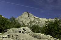
 Val d'Agnone from the upper part of the route Val d'Agnone from the upper part of the route |
Col de Vizzavona in the centre of Corsica is also located at the centre of Corsica's great trekking trail GR20. It is the only spot along the treck were treckers can find accommodation other than tents, where they can stock up on provisions and even take a shower. Also, many (half) treckers start or stop at Vizzavona, which makes the surrounding area quite crowded. Especially at the beginnings and ends of the days you will experience some kind of rush hour around the saddle.
Now, high above Vizzavona, located to the north of the saddle, you will find Corsica's number one lookkout mountain, Monte d'Oro, a huge standalone bulk of a mountain, made up from beautiful granite. One of the two normal routes, the Muratello Route, makes use of the trekking trail GR20 and indeed many treckers sidestep towards the summit, a difficult two hour scramble with a UIAA II+ climbing section up the summit block.
Taken by itself, the Muratello Route is a very strenuous affair. More than 1400m elevation gain at a distance of 14km need to be scaled, much of it on very steep terrain. There is a ridge traverse through a maze of granite blocks, a steep, shifting talus field and the final climbing section, itself also a maze. However, after all the effort you are awarded the best possible views. But take care to be early as weather often worsens around noon and fierce storms can develop out of nowhere.
Getting There
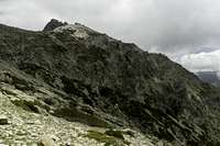
 The west ridge and Punta Migliarello during descent
Trailhead for Monte d'Oro is Col de Vizzavona, where you can find a huge parking lot. The saddle is one of the main road passes across the mountain backbone of Corsica. The road RN 193 connects the two main cities of the island (as well as airports). Bastia in the north and Ajaccio in the west.
Alternatively you can go to the village Vizzavona, which is located to the north-east of the saddle. The direct route along the Cascades des Anglais starts there but it requires about 100m elevation gain more. The parking lot in Vizzavona is near the train station.
Route Description
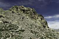
 Punta Cancellone and Punta Migliarello from above the gully
- General:
- Start altitude: 1200m
- Summit altitude: 2388m
- Prevailing exposure: S
- Type: Hike, Scramble, UIAA II climb
- Protection: None
- Start altitude: 1200m
- Effort: 3 - Elevation gain: 1400m
- Power: 3 - Strenuous
- Psyche: 3 - Chimney climb to the top
- Difficulty: 4 - UIAA II+
- Orientation: 3 - GR20 is marked, talus field and summit block difficult
Depending on whether you start at Vizzavona Village or Vizzavona Saddle the first half hour is rather different. From the village you follow GR20 through Val d'Agnone along the Cascades des Anglais beautiful cascades and waterfalls running through bathing basins. From the saddle you have to ascent to a shoulder with the ruins of an old hotel. From there a traverse takes you into Val d'Agnone where you join GR20.
 |  |  |
For the next hour you follow the valley along the cascades. The trail slowly gains elevation in many ups and downs until you get to the end of the flat part right beneath a big waterfall. Here the path turns to the left and very steeply climbs towards the Muratello Saddle in many switchbacks. However, before you reach the saddle the Monte d'Oro Route turns off to the right leaving GR20 behind.
 |  |  |
You traverse the slopes underneath the Monte d'Oro lower west ridge, slowly gaining ground until you reach a cut (gully). You have to descend a few metres into the cut, then climb back out of it (UIAA I+) across exposed ledges. Several more switchbacks take you up to the ridge, which you reach in a broad saddle and where you see the summit block for the first time.
 |  |  |
Turn right onto the ridge, which quickly narrows. The path switches sides as granite blocks and gendarmes block the way. You have to climb between several saddles, often steep and exposed. Finally you leave the ridge towards the south to pass one of the larger foresummits of Monte d'Oro.
 |  |  |
You hit a talus slope, which comes down from Epaule de la Jonction, the saddle to the south of the summit ridge. Here orientation is tricky as there are many trails which all lead upwards. The slope shifts a lot and since the scree is not very thick some spots are really tricky. Climb talus field upwards between the summit block and a tower to the south and you will directly hit the shoulder saddle, Epaule de la Jonction.
 |  |  |
From here a few steps take you to the summit block proper, where the technically most difficult part starts. The route winds around ledges to the west of the summit at first until it steeply climbs into the south face. Here a UIAA II+ Chimney of some 7m length takes you to a ledge on the eastern side and from there across exposed granite blocks to the summit.