
-
 2422 Hits
-
 77.48% Score
-
 8 Votes
|
|
Route |
|---|---|
|
|
42.86791°N / 0.20187°E |
|
|
Hiking |
|
|
Summer, Fall |
|
|
Half a day |
|
|
Hike and Scrable |
|
|
Overview
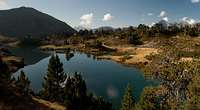
 Lac de Bastan Superieur Lac de Bastan Superieur |
The route from Col de Portet to the summit of Pic de Bastan is the shortest approach to the mountain, which is located quite central in the Néouvielle Natural Preseve. Also it is the approach with least elevation difference so that you mut be prepared to meet one or two crowds of people. It is a very beautiful route thanks to the many lakes you encounter in between.
Though some guidebooks claim the route to be a difficult hike, the biggest part of it does not pose any problems. The first third is a hike across the ski slopes of St. Lary, the middle half of the route crosses beautiful lake country to Col de Bastanet, from where the final 6th of the route runs across ledges with some exposure and finally - depending on the path you take - requires the use of your hands. However, an experienced hiker will manage the summit without any problems while the inexperienced ones turn around halfway up the ledge.
Getting There
 Starting out at Col de Portet
Col de Portet can be reached from Vieille Aure by a narrow mountain road, which is paved for about two thirds of the way.
- From Vieille Aure follow the signs to the Plat d'Adet and Espiaube ski resorts
- Where the parking lots of Plat d'Adet start a narrow road turns off to the right. It is paved but potholed and reported to be closed after September 30th.
Route Description
 Refuge de Bastanet
- Start altitude: 2215m
- Summit altitude: 2718m
- Prevailing exposure: N and W
- Type: Hike and Scramble
nbsp; - Protection: None
From Col de Portet follow the road for a couple of hundred metres onward. Here a narrow path (GR10) turns off to the right. It traverses the ski slopes underneath Pichalet, staying level for most of the time. A short descent into a valley and the path bends southward towards the southern end of the Pichalet south ridge. Here a sign marks the end of the ski runs and shortly afterwards you turn the corner to see the reservoir of Lac d'Oule lying 400m underneath.
 |  |  |
GR10 now heads north, steadily losing elevation until it reaches Lac de Bastan Inferieur, where a second ascent path joins from Lac d'Oule (also an option but roughly 400m more of elevation gain). The path heads for the right (southern) shore of the lake, does a quarter circle and heads up in eastward direction. After a short while it passes around a second small lake heading northward again. A few hundred metres and you stand on the shores of Lac de Bastan Medium.
 |  |  |
GR10 now heads along the eastern shore of this lake and quickkly climbs to a promontory on which you find Refuge de Bastanet overlooking Lac de Bastan Medium. Near the hut the path turns northward again and quickly reaches Lac de Bastan Superieur, which it only touches in its south-western corner. Turn left and traverse the rocks which bound the lake. Again heading north you reach a step in the terrain, which the path climbs in several switchback. Here orientation is a bit ambiguous as too many stone cairns mark too many paths, which all however follow the main valley leading underneath the final step beneath Col de Bastanet. Again, a few steep switchbacks take you higher and finally lead you into the saddle, from which the northern part of the Néouvielle Natural Preseve can be seen for the first time.
 |  |  |
Turn left onto the outreaches of the Bastan north-east ridge. There are two paths, one on each side of the ridge. Generally the northern path is considered to be the easier one as it avoids the scree fields south of the ridge. Both paths recombine in a small saddle which basically is located directly underneath the Bastan summit block. Here the ridge turns southward. Stay on its eastern side to avoid a rocky section but return to the ridge a few hundred metres later.
 |  | 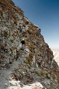 |
From here a ledge heads through the north face of Pic de Bastan. It is moderately exposed but rather steep and in one place there is a marble slab, dangerous in wet conditions. The ledge leads towards the west face and ends there. A narrow gully now heads down into the indication of a saddle, so steep that you'll have to use your hands as well. From the saddle the correct path heads up to the left onto the north-west ridge of the mountain. However, it is also possible to scramble straight ahead across the summit slopes towards the top.
 |  |  |