
-
 27759 Hits
-
 73.59% Score
-
 5 Votes
|
|
Route |
|---|---|
|
|
16.2667°S / 68.1833°W |
|
|
Download GPX » View Route on Map |
|
|
Mountaineering |
|
|
Spring, Summer, Fall, Winter |
|
|
One to two days |
|
|
PD+ / Ice+snow 45 degrees |
|
|
II |
|
|
Overview
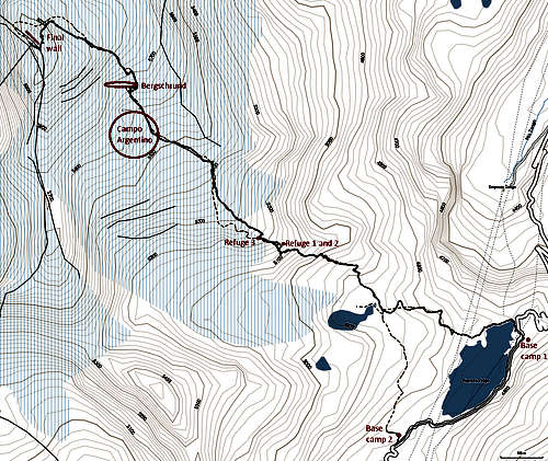
Annotated topo map
I will stick to objective information related to the route here; my trip report (Oh my guides!) contains more opinions that may help you plan an unguided climb or understand what to expect on a guided climb.
Getting there
See the mountain's main page. Have your transport drop you at either base camp.
Approach
There are gaps and overlaps between the pictures.
From the base camp closer to La Paz, follow the obvious trail up until it reaches a small glacier-fed lake. Follow the trail until on climber's right (North) of the lake. From the base camp further from La Paz, cross the dam and follow the aqueduct for a short distance. The trail forks left, following the reservoir, and ascends to climber's left (South) of a stream to join the other trail.
The trail now goes up a lateral moraine on climber’s right (North) of the glacier’s terminus and its lake. It starts ascending onto a ridge, then drops slightly in a cleft on climber’s right following a sign for the “punto de registro a turistas”, where you will part with 20 Bs. Since the trail then re-ascends the same ridge, it is obvious that it only drops at this point so that the “cash collector’s” hut can be in a sheltered area. You can stay on the ridge then scramble right, which some people have obviously done before, saving some scree (and 20 Bs if your ethics can live with that).
There is no more fork afterward, so just follow the trail up the South side of the moraine. The scree will become rocks and the last bit will ascend quite steeply, but footing is safe. When the first building is seen on the top of the moraine, it is the second refuge's outhouse. Aim past it for the tent sites, the third refuge or Campo Argentino. Traverse right (North) for the first refuge, as it is slightly lower and on climber’s right of the ridge.
When camping and going unguided, I would recommend to camp around the first two refuges since the spots are better, but do hike up to the third refuge to see the following day's route in daylight.
![Lower glacier]()
Lower glacier![Bergschrund]()
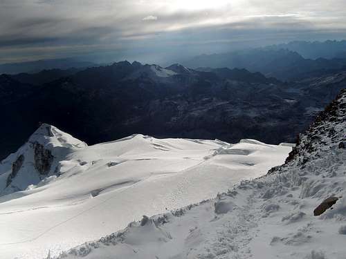
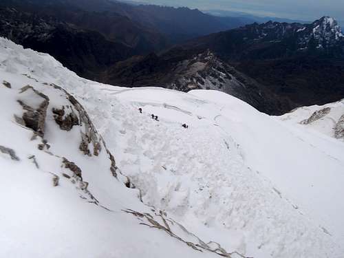
BergschrundFrom the third refuge, get the glacier travel gear on. The glacier drops not far on climber's left and there is a ridge far on climber's right; walk in-between. Aim up (Northwest) and right (North), getting to but not ascending the ridge, until a flat area at 5450 meters, Campo Argentino. This is at most easy route-finding on a wide and low-angled glacier. Truth to be told, unless you are the first team after a snowfall, there will be an obvious track around crevasses. Find your preferred spot for camping and you can go all the way to 5600 meters, but you will have a slight slope to manage.
![Upper glacier]()
Upper glacierAfter Campo Argentino, keep up and right (NNW) and you will face a bergschrund. The path will probably be obvious in the snow from earlier climbers, reaching the base of the bergschrund at the easiest crossing site. Try S16°15.931’ W68°08.814’ (WGS84) if you have a GPS, where there was a good quality snow bridge (![Snow bridge]()
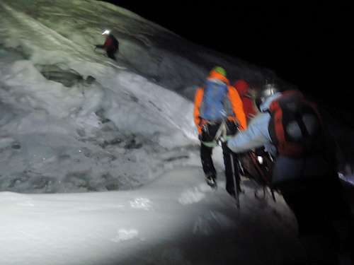
3 men on a snow bridgeas in 3 people were standing on it) reaching the middle of bergschrund's upper wall, followed by a diagonal crawl up and beyond its upper wall on 45° snow for 25 meters, on a trail almost a car-wide since everyone climbed there. If there is no snow bridge and one has to fully down-climb the bergschrund, 10 meters of AI2 may have to be climbed to scale its upper wall.
Route Description
Lower glacier
Bergschrund
Upper glacier
3 men on a snow bridge
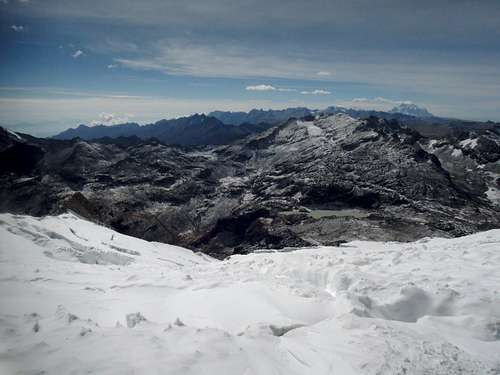
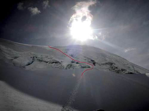
After the bergschrund, the glacier flattens, and it is again a matter of easy route-finding around crevasses, going up (Northwest) and left (West). Head past the South summit on climber's left, and you are at the final wall. ![Final wall]()
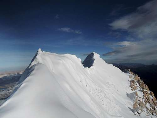
Final wallEither head straight up that wall, on 30-45° well protected snow and some short mixed terrain, to the Southern summit ridge, or go around to the Northern summit ridge and walk up that one, with more gentle slope. ![Final ridge]()
Southern ridgeOn both ridges, a short walk is required on a thin arête to reach the summit. Some guides may avoid that arête if it is heavily corniced.
Final wall
Southern ridge
Descend by the same way. The mixed part of the final wall may need to be down-climbed but there is no need for rock protection. The bergschrund may be down-climbed with snow or ice protection depending on conditions. Near the end of the descent, make sure you head to the correct base camp when the trail splits.
Essential Gear
Boots: front-pointing can come handy but is not necessary on the normal route. So if you already have warm boots, get strap-on crampons and you can skip the old plastic boots they rent.
Ice ax, crampons: mandatory, but unless you know how to inspect them, expect to rent dull crampons and an ice ax that is too long or too short. And bicycle helmets…
Ice screws, snow pickets: not all guides (and therefore rope teams) bring them. One should carry one or two of each if the team’s skill is low.
Crevasse rescue gear: guides do not bring them, but there are crevasses big enough to swallow a person. Decide for yourself.
About the guide packages
All the mountaineering agencies in La Paz will offer this trip. Prices quoted to me to join an existing group was 750 to 1000 Bs (without negotiating) in October 2016, for 2 days, refuge, meals and no equipment. Skipping on, equipment, meals or refuge may or may not affect the price depending on the agency. On the mountain, I found most people paid in the upper range or even more. For the same conditions, I was quoted 880 to 1200 Bs (with some negotiating) for a private guide.
Group vs private. With groups, try to have at least two guides in the group so that if one person has to head back, the rest can continue, but whatever they promise in La Paz may not be true once on the mountain. People who want to go faster or want to maximize their summit chance may choose to go private.
2 vs 3 days. On 2-day packages, one day is used to approach up to a high refuge and one for summiting and descending. The 3-day package adds a half-day mountaineering workshop and a night at the base camp. A proper mountaineering course is many days long, so do not expect too much. They may even cancel the workshop altogether "to not wet your gear" if the weather is not perfect (no money back obviously). The 3-day package helps for acclimatization too, but if this is your priority, you are better to head to the high refuge on the first day, learn mountaineering or "climb high sleep low" on the second day, and summit on the third day.
For the rest of the decisions, the packages will be similar across the board. All base camps and high refuges are actually quite similar, and food will be basic in all cases. The quality of rental equipment and guides will vary with agencies, but it is impossible to get objective information on which agency is better.
gilles debray - May 29, 2003 8:06 am - Hasn't voted
Route CommentIf youé planning to climb Huayna Potosi you should contact Bolivian Journeys. We did and it is a really good company, their guides are amazing, ask for Eulogio, Vicente or Luis.
Haliku - Apr 8, 2008 9:15 pm - Hasn't voted
Second hut?Isn't there a second hut now? Updated beta would be great. Cheers!
lenazavaroni - May 24, 2022 2:23 pm - Hasn't voted
Two-day Huayana Potosi climbI've just completed the two-day climb up Huayana Potosi. It went much as has been described on this site, although I was a bit out of shape and running on empty most of the time! This made my time 8hrs 20 mins, getting to 'la cumbre' at 9:20am. The other two in the group made it by 6am. The weather was optimal (May), meaning crisp, crunchy snow and great visibility. The views from the top in the brilliant sunshine were obviously spectacular, and one could see Lake Titicaca in the distance. I went with Jiwaki, whom I can't praise enough for their professionalism and, in my case, patience!
benbrough1 - Oct 1, 2022 7:24 am - Hasn't voted
2 Day Huayna Potosi ascent with William of JiwakiWe just climbed Huayna Potosi in 2 days (we cycled to the base camp from Condoriri so we were relatively confident of acclimatisation). We booked through Jiwaki tour agency who were incredibly helpful in organising rental equipment and water to be brought to base camp for us. Equipment was generally pretty good; ice axes weren't sized but were adequately sharp and not rusty, crampons were pre-set for our boots, helmets and harnesses we're both Petzl and in good condition, additional clothing was offered (we didn't need it) and was basic but very warm looking! We booked a private guide ~1300BOB but for logistics and convenience they ran the first part of the ascent to the high camp as a group, before we made the final ascent with our guide. The first part of the climb was extremely well run; great food, motivated and friendly guides and time to chat and meet the other climbers in the very comfortable 'Happy Day' refuge. The ascent to the summit went really well, the weather was excellent and we had amazing conditions most of the way. Our guide was both really competent and great to chat to on the way up (William's English was excellent, a real rarity in SA). We summitted around 6:30am, perfect timing for sunrise and were back down to the high camp around 8:30am. All in our experience was incredibly positive; we had considered doing the ascent without a guide (partly due to reports on this site and partly due to experiences in Peru) but in the end we were so so happy we opted for a guided ascent. Unlike our Peruvian guide (who was competent but uncommunicative in Spanish or English), William (and the other Jiwaki guides) really enhanced the experience. We also thought the route finding (around crevasses and across the final glacier approach) was more complex than indicated in other people's reports (although this was likely due to the lateness of the season and the general state of the glacier, I guess conditions and difficulty vary greatly). We didn't find the ascent to be technically difficult, our guide set up an abseil for the short section on to the ridge but down climbing would have been fine for a semi confident climber. Despite reports of 50% successful summit rate, all of the Jiwaki clients made it to the summit that day (there was a huge variety of experience and acclimatization levels) and I think a lot of that can be accredited to the guides. I wouldn't hesitate to recommend Jiwaki to anyone considering climbing Huayna Potosi. Our guide William can also be contacted directly on WhatsApp (+591 63194938) for ascents of any of the peaks around La Paz and further afield, again his English was excellent, his mountain competency was extremely high and his enthusiasm was infectious!