
|
|
Route |
|---|---|
|
|
0.26670°N / 78.1667°W |
|
|
Hiking, Scrambling |
|
|
One to two days |
|
|
Mid altitude scramble |
|
|
Class 4 |
|
|
Overview
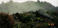 Typical vegetation en route
Imbabura's normal route is popular and to my knowledge a very high percentage of climbers and trekkers going to Imbabura aim for it. I have not heard of other routes on the peak.
It attract backpackers passing through Ecuador as well as mountianeers who want to acclimatize for higher peaks. It's not a technical climb, but persons with limited experience in the mountains can find it a bit scary to walk the crater rim and some scrambling may be too tough. An experienced climber will probably see at as a high altitude walk with nice views.
It's a quite long and also relatively strenuous walk for anyone.
Altitude gain from road's end (Chiruasi): 1600 meters.
Note!
It was a long time since I was on the peak and I only remember the general features of the route. The details I can't recall. If you have climbed Imbabura and feel something isn't correct or you want adopt this page; please drop me a line.
Getting There
 Grassy section, followed by some of the first scrambles
For detailed directions; see the main page.
Ecuador - Quito - Otavalo - (Ibarra)- La Esperanza - Chiriuasi - Imbabura.
If you head from La Esperanza to Chiriuasi on foot, it's about 3.5-4km. Ask the locals for directions on how to get to Imbabura. They seemed to be very used to this question.
No Spanish?
No problem.
Just point at the peak, look lost and say; "Imbabura"?
Route Description
 En route
Out of Chiriuasi there is a small motorable road. It was very muddy and quite steep in sections. I guess a good car can make it a km or two upwards, but it has to be dry. I had a hard time on my MTB.
The path is obvious and if in doubt, just follow the main ridge and you'll find the path very soon.
The walk is most of the time steep. In the beginning you're surrounded with some smaller trees here and there and a high, rough grass is covering the ground. If you loose the trail, the grass is hard to walk in.
The grass disappears gradually and more and more rock appears. The first rocky part goes along a good path without difficulties. Some very easy routefinding follows, but watch out if it's foggy/cloudy.
 Typical scrambling
More and more small "walls" appears, usually with some flattish sections in between. There are some easier scrambling and a few climbing moves. The rock is quite rotten, so be careful. If you loose the route, you better go back down a bit locating it, or the risk of having to deal with some steep climbing is big.
When on the rim itself you're mostly in for a walk on scree, with two scrambling sections. The first is the most tricky and I saw a large party of trekkers turn back here. I found it best to climb straight up to the top of the little rocky section. Be careful here and also on the rest of the walk to the true summit. The gravel is loose and the rock rotten and most of the way it's quite exposed. The highest point of the rim is a little rock formation. There are some small souvenirs and a cairn.
Essential Gear
Wind and waterproof clothing.Good boots, preferably also gaiters.
A little day pack with snacks and water.
Walking poles is an advantage.
A guided group brought a rope (no hardware or harnesses) for the scrambling sections.
Imbabura can be done in jogging shoes, shorts and t-shirt. I regretted that choice of outfit when in the cold clouds and the shoes constantly full of gravel.