
-
 21141 Hits
-
 86.37% Score
-
 22 Votes
|
|
Mountain/Rock |
|---|---|
|
|
42.25570°N / 108.856°W |
|
|
Hiking |
|
|
Spring, Summer, Fall, Winter |
|
|
8612 ft / 2625 m |
|
|
Overview, Getting There, and Route Description

Overview
Oregon Trail pioneers recognized the Oregon Buttes as the halfway point of their journey. North Oregon Butte, the highest of them and the closest to the road accessing them, is on the Continental Divide and is one of a few “triple divide” summits in the Rocky Mountain West. Rainfall on it runs west to the Pacific, east to the Atlantic, or into the vast Great Divide Basin, where it goes nowhere except into the thirsty ground.
Although a desert-and-sage sea surrounds it, North Oregon Butte and its neighbors are semi-moist islands. Limber pines grow on the eastern slopes and seem wildly out of place as one walks along the flat top of the butte. A few aspen groves, even more wildly out of place, exist on north-facing slopes. Elk and mountain lions even survive here, confined to these tiny ecosystems. Birds of prey, including golden eagles, are common.
Below the slopes, the jaws of the desert await. Where the ground is not an expanse of sagebrush, it is riddled with clay badlands that turn to mud when it rains and make for treacherous, exhausting footing when dry. A saddle connects North Oregon Butte to one just west of it, but South Oregon Butte stands isolated, a true desert island.
The buttes are in the Jack Morrow Hills section of the Great Divide Basin and are the centerpieces of the Oregon Buttes Wilderness Study Area, which has been recommended by the BLM for wilderness status.


Getting There
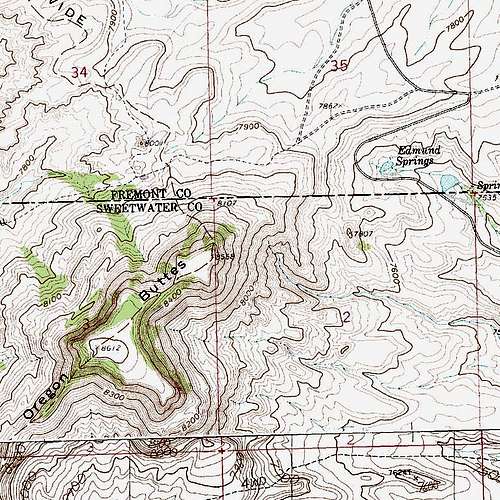
From WY 28 just west of the South Pass Rest Area beside the Sweetwater River, turn south onto Oregon Buttes Road. In dry weather, this road is easy to drive and is suitable for almost any car, but it can turn into an impassable gumbo when it is wet. At 9 miles, the road crests a rise in full view of the northern and southern buttes and then drops. About 0.3 miles from the crest, look for a faint road heading right. If you pass the last of the ponds of Edmund Springs, you have gone too far. Park here or drive the road for 0.1 mi to its end, where a sign indicates that the road beyond this point is closes to motor vehicles.
Note: You can save some hiking distance, elevation gain, and tedious hiking up clay badlands if you notice a faint road shortly BEFORE the rise at 9 miles. This leads to a gate on the slopes of the butte, and from the gate an old road climbs steeply upward as a de facto trail. It is this old road that I hiked to from the lower parking area.

Route Information
Basic Route Information: approximately 4 miles RT with 1200’ of elevation gain.
There is no trail system in the Oregon Buttes. Climbing North Oregon Butte, or any other of the Oregon Buttes, is really a matter of picking a way and seeing if it works. Erik Molvar describes a route in his book Wild Wyoming (Falcon Press), but I found his directions confusing and took my own way, which is the way I describe on this page.
From the parking area across from Edmund Springs, start hiking west to the badlands. Angle northwest you climb them unless you want to deal with deep ravines and a longer approach. Then start climbing north-northeast (past the badland formation shown in this section) until you reach an old road running up the butte at a steep grade. Follow this road as it turns into a path that reaches the top of the butte.

Don’t get too excited, because you’re not yet at the highpoint. You are on the eastern promontory (AKA the false summit) of North Oregon Butte. Hike west to a saddle that connects to the higher summit, but take some time to walk over to the northern and southern rims of the butte to take in the views, which include South Oregon Butte and the Great Divide Basin to the south and the Wind River Range and the badlands of the Whitehorse Creek area (studied but not recommended for wilderness status by the BLM because of its potential for oil and gas extraction) to the north.
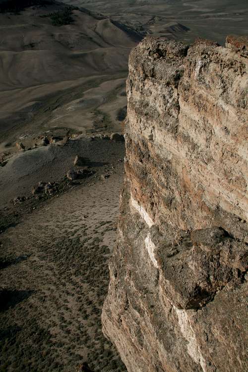
Crossing the saddle does not make you give up very much elevation. Once back atop the butte, find the highpoint (not marked) near the western end if you want, but do not miss the open clifftops at the southwestern end of the butte, where sheer cliffs drop to the desert floor and other buttes interrupt the monotony of the sagebrush ocean all around.

To descend, I found some moderate dirt and grass slopes on the western face, and they led me to a bench below the butte’s cliffs but above the desert floor. I then engaged on a cross-country trek back to my car, but I erred by dropping too low into the badlands and having to drop into and climb back out of a deep ravine, which was neither easy nor fun. If you go back this way, which is scenic and worth it, stay as high and as close to the butte as possible once you descend to the bench mentioned.
Some Summit Views


Red Tape and Precautions
Don’t drive past signs prohibiting motor vehicles.Spring through fall are the best times to visit the area, as winter can be bitter and snows can block the roads. But do be aware that summer can be brutally hot and with little or no shade from clouds and trees.
For water, follow the rule of one gallon per person per day. Any groundwater you find here will most likely be alkaline and unsuitable for drinking even after filtering or boiling it. In fact, since rain can make the roads impassable, don't head out here without at least one extra day's supply of food and water.
Camping
There are no campgrounds out here, but you can just set up camp practically anywhere. Avoid camping in washes and other low spots, of course.More Information
Good information about the Great Divide Basin is not easy to find; I have tried numerous Internet searches. To date, the best information source I have found is Erik Molvar’s Wild Wyoming (Falcon Press), which has its flaws as a guidebook (chief among them is the lack of maps and route diagrams) but has a large section on the Red Desert, which includes the Great Divide Basin.Also very valuable to have is the Wyoming Atlas and Gazetteer, which shows the roads out here.