
|
|
Mountain/Rock |
|---|---|
|
|
39.91769°N / 119.99517°W |
|
|
Washoe |
|
|
Hiking, Scrambling |
|
|
Spring, Fall, Winter |
|
|
5794 ft / 1766 m |
|
|
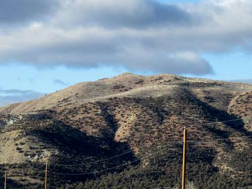
North Red Rock Summit from Red Rock Road
Located just within the Nevada border, this unnamed summit is the a worthy destination for peak baggers. It could be considered the west summit of Seven Lakes Mountain. But it is more appropriately the North Red Rock Summit. It rises above the Red Rocks in Lassen County, California and rises northeast into Nevada.
While unnamed, this summit actually does have a prominence of about 360’. The views are quite excellent with Northern Sierra Nevada peaks to the west and numerous desert peaks in every other direction, including a wonderful view of the Petersen Mountain Range to the south.
The best part about this mountain is the approach. The approach starts at the “Red Rocks”, an attractive area with vibrant colors and geology.
The mount is easily accessed, right next to a major highway. The summit is only 1.3 miles from a paved road.
The best time to hike in the Red Rocks area is late October through April. Avoid the area after rain storms; it is better hiked in dry conditions. The summer is too hot, and snakes can be an issue in rocky areas.
Getting There
There are two ways to reach the Red Rocks from the Reno/Sparks area. Take US 395 North towards Susanville, California. Once entering California, drive about 17 miles to the Red Rock Road exit. Drive ½ mile east on Red Rock Road and park on the left (north side of the road). A road leads towards the Red Rocks. The road starts at 39.90775, -120.0053.You can also take a longer scenic route up Red Rock Road from the south entrance. The driving mileage is similar, but the speed limits much lower, so it takes 10-15 minutes longer.
Starting at the Red Rocks is the best alternative. Although the summit can be reached from other directions, this is the most straight-forward and most scenic.
Route
From the parking area, hike up the road towards the Red Rocks. I prefer a loop, starting by looping up behind the Red Rocks and heading up the ridge. To do this walk below the Red Rocks, and take a road heading to the right. It leads to a dry creek bed. Stay on the left of the creek bed and head towards a ridge with a slight use trail heading west behind the top of the Red Rocks.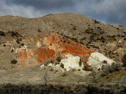
North Red Rock Summit above the Red Rocks
Head up the ridge, generally heading northeast to the summit. A Google Earth™ map is helpful. The summit itself is unnamed, and is noted only as “1766” on topographic maps, for 1,766 meters or about 5,794’.
The total one way distance via this route is about 1.3 miles, with an elevation gain of 1,235’. A good way to descend is to head east from the summit down to a ridge on the east side of the Red Rock canyon. This way you have views into the canyon on the descent. It is pretty steep on the way down, but not unmanageable. If doing this loop, the hike is about three miles round trip.
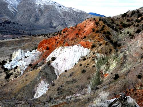
The Red Rocks seen from the east ridge