
-
 4158 Hits
-
 77.48% Score
-
 8 Votes
|
|
Route |
|---|---|
|
|
36.42346°N / 116.82597°W |
|
|
Hiking, Scrambling |
|
|
Spring, Fall, Winter |
|
|
Overview
The way up Manly Beacon is pretty intuitive, especially if you are approaching from Zabriskie Point, from which there is a spectacular view of the peak from the very start. The only real difficulty in dry conditions is finding the wash that accesses the base of the peak below its east face; from that wash, you take any of a few options to reach the summit ridge. In my opinion, the best option is to scramble up the loose clay gully and slopes at the end of the wash; that way reaches a small saddle between Manly Beacon and its neighbor, Red Cathedral, and it is just a walk, though sometimes a very steep, loose, narrow (sometimes the summit ridge is just wide enough for walking), and exposed one, the rest of the way. There are also some ridges that climb from the wash to the summit ridge, and I have used them before, but they are steeper, with worse footing, than the way I believe is the best one.
This page's purpose is less to provide a step-by-step route description and more to present a series of beta photos showing the route and conditions.
Round-trip distance from either Zabriskie Point or Golden Canyon is between 3 and 4 miles; elevation gain can be up to about 800'.
The Route
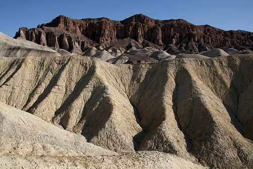 View of Red Cathedral from the off-trail approach to Manly Beacon's north ridge. You are looking for a wash that will take you to the base of the red cliffs on the left side of the formation while staying next to the base of Manly Beacon. If at first you don't find the correct wash, head over a ridge and down to try again.
 Follow this wash to access either the Manly Beacon-Red Cathedral saddle or one of the better east-side ridges branching from Manly Beacon's north ridge.
 End of the line-- This is the end of the wash that leads to the start of the route up Manly Beacon. The red cliffs are part of the Red Cathedral formation, which is not climbable from this position. To reach Manly Beacon, hike west (left) up the steep clay slopes at the end of the wash and reach a saddle, from which the route to the summit is obvious.
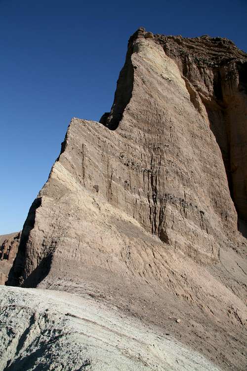 Seen from the saddle between Red Cathedral and Manly Beacon. Red Cathedral is NOT climbable from here; the rock is too unstable for protective gear, and the cliffs are too steep for all but the best and/or craziest free soloists. Better idea: take the hiking route and live to climb another day.
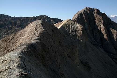 The summit ridge from the Manly Beacon-Red Cathedral saddle.
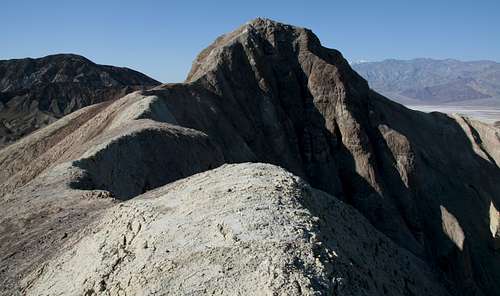 From between the Manly Beacon-Red Cathedral saddle and the steepest, narrowest parts of the summit ridge.
 From between the saddle between Red Cathedral and Manly Beacon and the final push up to the summit.
 Final push-- The route is only wide enough for one person here. There is significant exposure on both sides of the ridge most of the way. It is only Class 2+, but it is harder coming down, as it is very steep, narrow, and slippery.
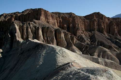 Looking back along the ridge to Red Cathedral
Getting There
Start at Zabriskie Point, the very popular and very beautiful viewpoint about 5 miles east of Furnace Creek on CA 190. An alternate approach can be made via Gower Gulch, which requires parking at the Golden Canyon Trailhead, about a mile south of Furnace Creek on CA 178.
Precautions
Please try to stay on the "real" rock and on the buttes that have hard-packed trails as much as possible. The makeup of many of the buttes is loose and easily damaged, and your fun does not justify making long-term scars on the formations.
This is one of the hottest places on the planet, with summer daytime highs usually topping 110 degrees Fahrenheit and often surpassing 120 (I have personally “experienced” 130 at nearby Badwater Basin). Not carrying enough water can be fatal (one gallon per person per day is the recommended amount). It is best to visit this area from late fall through early spring, but it is accessible all year long.
This is also a dangerous place to visit during wet conditions. Flash floods can be sudden and deadly, and it only takes a little moisture to turn the clays of the badlands into a goo that is almost impossible to hike through. Your feet can literally become stuck in the mud, and your next steps may leave your shoes behind.
Finally, avoid entering the numerous old mine openings in the area. You are allowed to go up to them and look inside, but it against park regulations to enter them. Among the reasons: deadly gases; scorpions, black widow spiders, and rattlesnakes (the old mine tunnels make perfect dens for these animals), and unstable ceilings.