
|
|
Route |
|---|---|
|
|
36.87000°N / 118.7333°W |
|
|
Scramble |
|
|
One to two days |
|
|
Class 3 (YDS) |
|
|
Approach
There are two general approaches that lead to Mount Harrington's east side from where you can ascend the North Ridge (most popular), South Arete, or East Face. The two approaches, described below, entail 9+ miles of class 1 hiking and 6,500+ feet of elevation gain to reach the summit.
LEWIS CREEK APPROACH: Use the Lewis Creek Trailhead (4,500') described in the main Getting There Section. This 9.3 mile class 1 route reaches Frypan Meadow (7,900') in 6.2 miles on the way to Grizzly Lakes (9,650') in another 3.1 miles. Along the way, the trail crosses a number of creeks on it's way to the summit including Comb Creek at 6,000' and Lewis Creek at 6,680' on the way to Frypan Meadows. After Frypan Meadow you will cross the East Fork of Grizzly Creek at 8,200' and 7.75 miles from the trailhead before reaching the last ridge before Harrington at 9,800'. From here you can climb Harrington or make your way down to camp at Grizzly Lakes (9,650').
DEER COVE APPROACH: Use the Deer Cove Trailhead (4,400') described in the main Getting There Section. This class 1 route is similar in length to the Lewis Creek Trail but: (1) offers better views of Mount Harrington, the Grand Dike, and the Great Western Divide, (2) cross less creeks (only 2 - East Fork of Grizzly Creek described above and Deer Cove (5,600') 2 miles from the trailhead), (3) is much more sandy for the majority of the hike, and (4) is not located in the National Park so is not subject to quota restrictions. Head north towards Wildman Meadow and then towards Grizzly Lakes (9,650') joining the route above just before the final ridge.
 |
Route Description
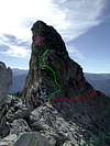
From the ridge at 9,800' or camp at Grizzly Lakes, hike into the meadow just beneath Mount Harrington's East Face at about 10,080'. Your immediate objective is the knob /bump at the base of Harrington's North Ridge and there are three general ways to get there. The most direct route is to head east and climb up the ridge to just north of the small knob / bump. Another popular and easier route is to head up northwest to the end (climber's right) end of the long short ridge crest (Monarch Divide) and boulder hop along the ridge crest to the knob at the base of the North Ridge. Finally, you can hike directly north to a gentle saddle (even more to climber's right than 2nd route and the longest distance) and head southwest along the Monarch Divide ridge crest to the base of the North Ridge.
Once you are at the base of the North Ridge, the route is fairly obvious - straight up! There are several variations the first of which being the first 30' where you can either take a direct class 3 climb up or traverse around the west side for a class 2 way up. There are a number of class 3 moves to the summit from there.
 |
Essential Gear
None during snow-free season. Ice axe, crampons, and snowshoes may be needed during early or late season ascents.
Miscellaneous Info
If you have information about this route that doesn't pertain to any of the other sections, please add it here.