

Dmitry Pruss - Sep 29, 2005 2:01 pm - Hasn't voted
more details for the mapPW,
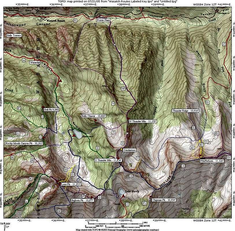
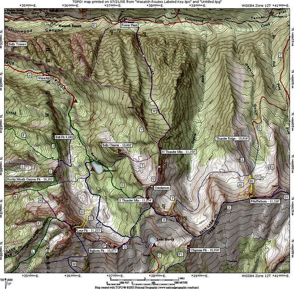
1) the "blue" route connecting to rte Y may be continued towards the "gendarmes" as class 2 - 3, it's a classic
2) the saddle behind Bells Cleaver is easily accessible from the NW all the way from meadow at the confluence of forks of Bells Cyn, as well as along the ridge connecting it with N-S Thunder ridge.
3) are you sure Sam Thomas route is where you placed it?
Thanks!

Joseph Bullough - Sep 29, 2005 2:49 pm - Hasn't voted
Re: more details for the map3) are you sure Sam Thomas route is where you placed it?
My understanding was that Sam Thomas begins in the first drainage west of Coalpit, then traverses east until it joins the Coalpit Gulch route. This would place it well to the right of the location currently shown.

PellucidWombat - Sep 29, 2005 9:28 pm - Hasn't voted
Re: more details for the mapI just took my best guess, based on what chute looked the most pleasant in terms of cliffs and vegetation as seen from the canyon and aerial photos - if someone knows for sure where it is, let me know!
Dmitry Pruss - Sep 29, 2005 4:07 pm - Hasn't voted
Another Qanybody knows anything F & G routes on this map? I've spent a good deal of time trying to locate any trails in these two drainages, but no luck...
PellucidWombat - Sep 29, 2005 9:30 pm - Hasn't voted
Re: Another QI got those 'trails' froma backcountry skiing map. I've hiked a number of trails in the LP area that were in the guide but not in the Wasatch Mtn Club topos, so its gotta be somewhat accurate. Next time I'm in SLC I'd like to find those trails to climb Rocky Mouth Canyon Pk & Bells Pk!
Dmitry Pruss - Sep 30, 2005 2:55 pm - Hasn't voted
next timePW, you mean this greenish-bluish map with a funky 3D representation of snowcover / avy danger and some aerial shots included? It had some interesting trails missing elsewehere, including my fav Argenta trail to Kessler... but some of its routes may be just that ... potential XC routes?
Drop me a line if you around and in the mood to explore it :)
PellucidWombat - Oct 3, 2005 7:30 pm - Hasn't voted
Re: next timeExactly - I'll let you know when I'm visiting SLC again :-D
Dmitry Pruss - Oct 31, 2005 1:13 pm - Hasn't voted
Actual Sam Thomas location / linkPW,
I posted a route description for Sam Thomas, along with a few GPS waypoints. It actually starts where you placed an "ice climbing" symbol (which in actuality belongs maybe 1/8th of an inch to the right, in the adjacent gully).
PellucidWombat - Nov 12, 2005 9:18 pm - Hasn't voted
Re: Actual Sam Thomas location / linkThanks! I've been too busy here at school to incorporate changes in my SP submissions, but this Winter Break I'll get on top of it!


Comments
Post a Comment