
|
|
Route |
|---|---|
|
|
39.92250°N / 105.69583°W |
|
|
Hiking, Mountaineering |
|
|
Summer |
|
|
Half a day |
|
|
Class 2 |
|
|
Overview
This is the easiest route up the mountain and is a pretty short climb. The route descends from the Rollins Pass Road to the beautiful Pumphouse Lake before climbing the Northeast Ridge of Mount Epworth to the summit. There is no real trail to the summit of the peak and there is some class 2 scrambling, but this is a steep, but fairly easy ascent that can be done in a few hours. Since the climb is short, I recommend this as a good sunset climb. The sunrise would be nice too, but higher mountains to the east would obscure the best of the sunrise.You can make the trip longer by combining it with the hikes to Corona Lake and/or Deadman Lake as well.
 This is the gentle section of the northeast ridge. Above this section, the route becomes more rugged.
Getting There
Drive Highway 40, either north of Fraser, or south of Berthoud Pass, to just north of the main Winter Park Ski resort. Between mile markers 231 and 232, turn east on to the road marked for Corona/Rollins Pass (14 miles from Highway 40). This is County Road 80 (the road becomes Forest Road 149 after reaching the forest boundary). Follow the main road about 12.5 miles to where you can clearly see Pumphouse Lake to the west and below as well as a trail heading down the hill. Deadman and Corona Lakes should also be visible and there is a wide spot to park in the road. The road is rough in places, but cars can make it all the way to the trailhead when driven slowly and with great care.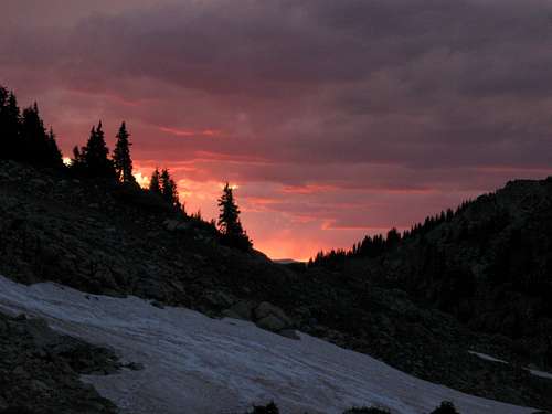 Sunset on the slopes of Mount Epworth on July 13 2009.
Route Description
From the trailhead, follow the old wagon road/old Jeep road down the hill and to the north. After a short distance, a trail braches off to the left and descends to Pumphouse Lake. Head to the north side of the lake and cross the creek to the opposite side.The northeast ridge of Mount Epworth is your objective, so just after crossing the creek, climb up to the ridge. There is no trail, but there are a few scattered cairns along the route. Follow the indistinct ridgeline through the tundra and boulder fields to the summit. There is some class 2 boulderhopping along the route, but anyone should be able to handle it. The steepest section of the route is just before the top, but after this short section you are rewarded with many spectacular views.
You could return the same way or explore the mountain more thoroughly and via other routes. In July and if you bring an ice axe, there are some good glissades on the way down. Also consider hiking to Corona and/or Deadman Lakes on your return.
The round trip distance to the summit and back is only two miles or so, but the route is steep and slow in places. A couple hours should be enough for most people if you climb the peak only, but you can make this into half day or even all day trip by exploring the nearby lakes and basins.
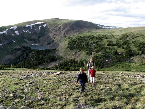
 Kessler waits on the summit of Mount Epworth for his mom and sister to complete the last section.