Introduction
This is the story of our grand trip through the Utah and Arizona Canyons that took place between April 11 and 20. The trip began with an email to Todd Martin, a well know Arizona canyoneer/climber. Todd runs the website
Todds Desert Hiking Guide and is also the author of the book
Arizona: Technical Canyoneering. I had been completely luckless trying to put a group together for a Buckfarm canyon and Saddle Canyon attempt for quite a while, in fact for several years. With the remoteness, ruggedness, climbing required, time and commitment it was hard to find anyone interested in such a trip. I was in luck because Todd had recently attempted Buckfarm Canyon twice and also wanted to complete the descent and climb out. A few others were interested, but it was Rich Rudow and Aaron Locander (who was also on one of the previous Buckfarm Canyon attempts) that committed to join us for this fantastic proposed trip. Plans were made and anticipation and enthusiasm was high.
For more photographs, see the various trip albums:
Buckfarm Canyon/Eminence Break
Silver Grotto/Shinumo Wash
Antelope Canyon
Round Valley Draw
Hackberry Canyon
Stone Donkey Canyon
Yellow Rock
Sand Canyon (Colorado)
April 11 2008
Today I hiked Sand Canyon in Southeast Colorado while alone. There are some nice ruins in the canyon and it’s a nice hike. I had a pretty late start and got back right at sunset.
Buckfarm Canyon/Eminence Break (Arizona)
April 12 2008
Today was spent meeting and putting together gear, plus doing the long car shuttle and logistics. The other three drove up from Phoenix and I was from Colorado. We drove out to Buckfarm Point and camped admiring the huge yawning seemingly bottomless abyss thousands of feet below us.
April 13 2008
Now for the good stuff! Todd Martin, Aaron Locander, Rich Rudow and I started on our grand adventure down Buckfarm Canyon in Grand Canyon National Park. The climbers from the dam builder crew around the year 1950 came in here with a mess of huge metal rebar spikes to try and rig a route through Buckfarm Canyon. Whether or not they succeeded in completing the entire canyon or just to the waterholes isn’t entirely clear (but I think they did go all the way through), but since then only two known groups have succeeded getting all the way through this remote canyon. If successful, our group would be the third. As mentioned, this would also be Todd’s third attempt of the canyon and Aaron’s second. The previous party that made it through required four days, but we would attempt the descent and climb in two.
The morning was just below freezing, fine for someone who lives in the cold part of Colorado, but a bit cool for the Phoenix crowd. I would take the cool over the heat any day.
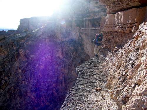
The excitement began right away. I pointed out a route down the initial cliff that I had found several years earlier, but it required the removal of packs and a spotter for the short downclimb. Todd and Aaron had found a more exposed route, but one that was quicker and didn’t require the removal of packs. We all started scrambling down a minor drainage until the bottom dropped out and it shot over a huge abyss. That’s when the action really started. We traversed left and onto a narrow ledge above a huge void. Narrow is the key word and the ledge got
really narrow as it rounded the corner. Hmm, this was getting a bit intimidating. As we crossed the ledge it got narrower and I could feel my legs getting shakier with the huge exposure and the carrying of the huge packs full of supplies, ropes and overnight gear. At the narrowest part we actually had to lean out over the void while using hand grips and slightly ducking and that’s when I could really hear my heart pounding in my ears. These ledges didn’t seem to bother Aaron or Todd as much, but I believe Rich found them exciting. I’m not as brave as I used to be and I found them to be very “exciting”. After we were all crossed safely I dubbed the traverse the “ledges of death”, a phrase that would be repeated many times in the upcoming trip. The other three were great climbers and it was a pleasure to be in such good company.
![Ledges of Death]() This is the first of the "ledges of death". Pictured is the easy part of the ledge, but Aaron is just coming around the corner where it was difficult. I couldn't photograph the scary part since there wasn't enough room for us to all stand there. Excuse the poor lighting, but the photo is a must for the trip report.
This is the first of the "ledges of death". Pictured is the easy part of the ledge, but Aaron is just coming around the corner where it was difficult. I couldn't photograph the scary part since there wasn't enough room for us to all stand there. Excuse the poor lighting, but the photo is a must for the trip report.
After the Ledges of Death the route became just a steep and difficult scramble down to the Supai layer of rock. There were a few fun downclimbs, but nothing like the previous ledges of death. We traversed the top of the Supai layer over to the south branch of Buckfarm Canyon. It was easy going until we had to find a route down through the Supai. Once again, Todd and Aaron had previously pioneered a direct route down into the south branch (there is a longer but easier route down to the south). There were some interesting climbs until we reached the next set of ledges. Dang, more ledges of death! These ones didn’t seem as bad at first until we set out to cross them. Might as well be free-soling the Hinterstosser I thought to myself while trying to keep a good sense of humor about this part of the route. These ledges pinched down to very narrow as well but this time the rock was loose and when Todd kicked one of the loose rocks off the ledge and it was a bit disheartening to hear how far it fell before hitting the ground. Here we were on the edge of oblivion with a gaping void below and crossing these ledges is a whole step up from roped rock climbing. We slowly made the traverse, but I wished I could keep my legs from shaking. I admit they were still shaking after completing the next set of the ledges of death.
![Part of route]() This is part of our climbing route in Buckfarm Canyon. This section was challenging, but not scary like the nearby "ledges of death". Tom Martin photo. Seen in the photo are Aaron, Rich, and me.
This is part of our climbing route in Buckfarm Canyon. This section was challenging, but not scary like the nearby "ledges of death". Tom Martin photo. Seen in the photo are Aaron, Rich, and me.
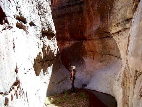
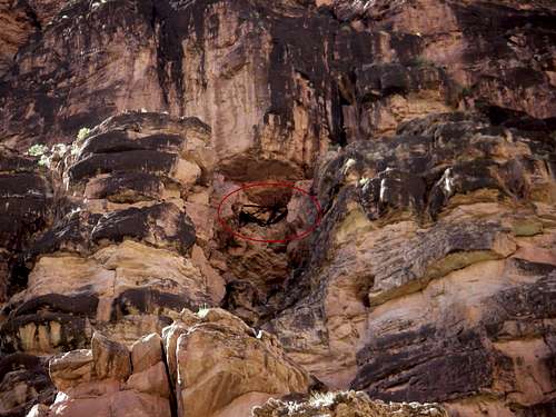
After the ledges were completed it was just a scramble down to the top of the Redwall Limestone layer. The north fork is where the old dam survey crew left rebar spikes, so we headed for there. Todd and Aaron had made it partially through the slot in late November 2007 so we already knew what to expect for the first half of the slot. It was amazing to see the old rebar spikes the dam survey crew hammered for an attempt to rig a rough route to the Colorado River (even though the spikes only existed half way through the slot the crew was probably successful, but that detail has been lost in time).
![Rich]() Aaron in a stone amphitheater on our climbing route through Buckfarm Canyon.
Aaron in a stone amphitheater on our climbing route through Buckfarm Canyon. ![Inside Buckfarm Canyon]() Inside Buckfarm Canyon.
Inside Buckfarm Canyon.
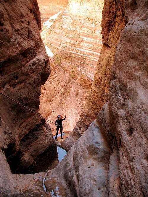
The technical section was actually quite straight forward and I found it to be the easiest part of the trip so far. There were four raps up to 160 feet and some very slippery down climbing on polished limestone, but getting through the technical section wasn’t too bad. Todd had brought a little pink kiddie raft to help float packs across pools and it made for some humorous photos and conversation. The technical section ended in a beautiful limestone amphitheater.
![Amphitheater]() Aaron in a stone amphitheater on our climbing route through Buckfarm Canyon.
Aaron in a stone amphitheater on our climbing route through Buckfarm Canyon.
We continued down canyon and found it amazingly beautiful. Water began to run, there were huge glowing red walls, blooming redbud trees, waterfalls and magical pools. We got to a fairly short waterfall (20-25 feet) in the Muav limestone where it slotted up. We were equipped with the gear, so we decided to do the slot directly. We rapped down the waterfall and with much wading and fun wet splashing and stemming we made it through the slot. It was then more or less a walk with several pitches of scrambling before we were finally at the beach of the mighty Colorado River.
![Beautiful Buckfarm]() A beautiful section of lower Buckfarm Canyon.
A beautiful section of lower Buckfarm Canyon.
We had made the full descent in a day, but we decided that we needed a bit more action. We headed down river (very tedious at first with some bushwhacking) down to what is known as Bert canyon (Bert Loper was a famous river rafter who died near here at age 80 while running the river). Berts Canyon was also very beautiful and ended in a hanging garden waterfall. We returned back to camp and spent the night on the beach.
April 14 2008
After a warm night it was time to get going early in the morning. We knew the day ahead would not be easy. We had four river miles to go down the Colorado and hiking along the river is never very easy. After that we would cross the Colorado River and have a 3000 foot class 4 chute to climb out before reaching the other vehicle.
Following the river required bushwhacking and climbing up and over many boulders. It was slow going but not too bad-yet.
We wanted to visit the ancient Bridge of Poles aka Anasazi Foot Bridge which is an old footbridge that is over 1100 years old and on a technical and very exposed route and was discovered in the 1970’s. The Anasazi were quite the climbers and Rich made the comment that judging from routes he had seen, if you weren’t born a 5.10 climber back then, then you were dead. Without a rope, the route up to the bridge is rather exposed(5.6) and the 1100 year old bridge is considered a mystery because it appears to end in highly technical big wall territory that some say was too hard for the Anasazi to climb. I don’t know though, judging from some of the other ancient Anasazi routes I’ve seen. The Anasazi have beyond doubt done routes in the 5.10 to 5.11 range and one route discovered out of Cow Canyon is a dead vertical 400 foot climb at least 5.10 in difficulty and the Anasazi did climb it (they left Moki steps to mark their passage). This Footbridge in the Redwall/Muav route would require some 900 feet to top out. Rumor has it that K. Grua and one other person have pushed the route all the way to the top of the Redwall (about 600 feet high) and that it is 5.12 in difficulty. Could the Anasazi have done a big wall ascent of such difficulty? Skeptics say no, but I think there is at least some evidence that they may have. There is a route up the cliffs through the Eminence Break on the opposite side of the Colorado and this route would make a full crossing of the Grand/Marble Canyon. Just the fact that they hauled large logs up the 5.6 pitches high on the wall says they were placed there for a purpose and that they were incredible climbers. There are also routes in other areas where they have climbed in the same difficulty range, but none so high. After climbing up the first pitches of the route (the Bridge itself is off limits and you wouldn’t want to cross it) we had to admire and tip our hats to the Anasazi climbers. It was quite scary especially climbing down the pitches and we weren’t hauling up any logs.
![Anasazi Foot Bridge]() Photo taken by Aaron of the Anasazi Foot Bridge.
Photo taken by Aaron of the Anasazi Foot Bridge.
After seeing and photographing the impressive Anasazi route and bridge it was time to cross the mighty Colorado River. We (or I should say Rich-I was carrying a climbing rope and we divvied up the gear) had carried a small raft down to cross the Colorado River. It sure looked like such a small raft to cross such a mighty river!
Anyway, there was one slight problem we hadn’t thought about. The small raft’s weight capacity was only 230 lbs. and taking chances on the frigid Colorado River is not a good idea and we all had heavy packs. Embarrassingly, I weight 232
without a pack. The only solution was to have Aaron (the lightest person) cross the river, drop his pack and return for mine.
Rich was quite experienced with crossing the Colorado and his plan was flawless. He had a cut off heavy duty fishing pole with a 135 pound test line (750 feet long). When someone crossed the river the test line was let out at the same speed the person was moving. When the person was finished crossing the test line was pulled back with empty raft.
Aaron was first to cross and did so with ease. The raft was small so he put on the life jacket and with the pack there was barely enough room, but still he only needed 350 feet of line. After Aaron, Todd also made the crossing with ease.
It was my turn now. Something went wrong at first since somehow the line was twisted around the paddle (but I was unaware until too late). It spun me around a few times, but it seemed OK. In the middle of the river the paddle snapped in two. To borrow from Steck (referring to the Colorado or any creek in the Grand Canyon), I was up Schist Creek without a paddle. I struggled to paddle across the river canoe style while thinking of how Todd and Aaron had such an easy time of it. Aaron grabbed me in the eddy to aid me to the shore.
Rich retrieved the raft and figured out a way to use the broken paddle in a scooping motion with each piece of the paddle in each hand. He also had an easy time of it. I guess I was really embarrassed by making such a dramatic crossing out of something that everyone else did with ease, but such is life.
![Crossing the mighty Colorado]() We crossed the mighty Colorado River in this tiny raft.
We crossed the mighty Colorado River in this tiny raft.
After we packed up the raft the going got tough. Hiking down river on the east side of the river was much more difficult than the west. There were more boulders and much more thorny and painful vegetation. It was also hot and temperatures soared to the mid 90’s which is quite warm for April. After what seemed like forever we were at the base of the Eminence Break chute which would be our route out of the canyon. We all took a break and since I was soaked in sweat and decided to take a dip in the frigid Colorado before attempting the nearly 3000 foot brutally steep chute in the full sun. I kept thinking the Phoenix members would have a much easier time in the heat than I would, but they said they were hot too.
The route up Eminence Break started out fairly easy. It was moderately steep but river runners had beaten a nice path up the cleft. It was still a very hot climb. The second half was much steeper and had loose rock. Todd was way ahead and every once in a while Todd and Rich would wait for me whenever there was meager shade. The upper end had some minor exposure and some stiff scrambling, but nothing over class 4. I found some small dinosaur tracks on the way out, but the others were too far ahead for me to call them to see them. The final part of the route had a huge bridge of sorts across the cleft that we would walk under. A rather large rock tower had fallen and jammed itself on either wall of the cleft and since the Eminence Break is a fault line, it probably happened during an earthquake.
After one move, we were all home free and the sun was just setting. It was a hard, but very rewarding day and a grand traverse of the Grand Canyon/Marble Canyon.
![Top of Eminence Break]() This is the top of Eminence Break and was our climbing route out. The route is only class 4, but quite steep. It was still much easier than our route down in through Buckfarm. Todd Martin photo.
This is the top of Eminence Break and was our climbing route out. The route is only class 4, but quite steep. It was still much easier than our route down in through Buckfarm. Todd Martin photo.
Since it was almost dark, we didn’t have time to poke around and loaded all our gear up and set off for the maze of “roads” and tracks in the Navajo Indian Reservation.
For the uninitiated driving in the Navajo Reservation is always “exciting” and it’s even more “exciting” at night. The best description I can come up with is that roads go everywhere and roads go nowhere. Even with our route traced on the photo from Google Earth and with careful preset GPS waypoints, we still got lost, but only a few times.
We were now at the head of 29.9 Mile Canyon aka Shinumo Wash. We spent a very windy night and some gear (such as Rich’s cot) was almost lost by blowing off the 1000+ foot cliff. We later learned that Page Arizona recorded 53 mph winds, but in our more exposed location it was surely higher. Rough night. We all could say we slept like a baby, but only the baby whose crib was left outside during a hurricane.
Note: In the essence of space, the rest of the trip report will be very brief.
Shinumo Wash/Silver Grotto (Arizona)
April 15, 2008
The next morning our happy and now hardened crew set out to attempt a full descent and ascent of Shinumo Wash/Silver Grotto, another Grand Canyon gem (Marble Canyon section). The route down was a straight forward, but very tedious and slow with much boulderhopping since we weren’t aware of the historic horse trail in the canyon bottom. It was a long trip down to the Redwall where the canyon became technical. Along with many spicy downclimbs, we brought six ropes and left one behind at each of the longer drops where we actually rappelled. A piton was pounded on the first drop, but we were able to extract it later as so to leave no trace. In addition to the raps and some quite difficult downclimbs there was swimming in frigid water in order to the top of the Silver Grotto. By the time we reached the Silver Grotto (known by river rafters coming up canyon, we were out of rope, so couldn’t descent into its depths, but we had made it to directly above the point where Rich Rudow had climbed up from the Colorado River while on a river trip.
![Into the green depths]() Aaron (top) and me (below) descending into the green depths of the Silver Grotto canyon. Only a few people have ever seen this section of canyon.
Aaron (top) and me (below) descending into the green depths of the Silver Grotto canyon. Only a few people have ever seen this section of canyon.
The hard part was coming back up the canyon. The other three ascended the rope but we decided to rig a haul system just for the heck of it I guess, but I didn’t mind since I don’t consider jugging to be much fun anyway. I climbed up the cliffs and when I couldn’t a haul system with pulleys was used. Excellent crevasse rescue practice for sure and the canyons are the only places where crevasse rescue is usually practiced in Arizona!
![Shinumo Wash]() Rich Rudow in Shinumo Wash/Silver Grotto Canyon. Todd Martin photo.
Rich Rudow in Shinumo Wash/Silver Grotto Canyon. Todd Martin photo.
On the return trip I found the old historic horse trail and we sped up considerably. We arrived back at the rim of the canyon at sundown.
Antelope Canyon (Arizona)
April 16, 2008
The original plan was a four day trip to Saddle Canyon, also in the Grand Canyon. Saddle Canyon is a pretty popular river stop, but apparently no one has connected the entire rim to river route yet. It was our grand goal for last week, but we gave up on it after being thrashed and beat by the other two routes we did in the previous days.
We attempted to obtain a Navajo permit for Aztec Creek, but were unsuccessful and so we headed to the Hackberry Canyon area of Utah. Before that we did a Quick trip through Lower Antelope since none of us but Aaron had seen it yet.
![Corkscrew]() The Corkscrew section of Antelope Canyon.
The Corkscrew section of Antelope Canyon.Round Valley Draw, Hackberry Canyon, Stone Donkey Canyon, Sam Pollock Canyon, and Yellow Rock (Utah)
After Antelope Canyon, we then headed for Round Valley Draw, Hackberry Canyon, Stone Donkey Canyon and Yellow Rock all in one shot in three days.
April 17, 2008
Round Valley is a really nice slot and great fun with some easy climbing. After meeting Hackberry Canyon and continuing down it, we also tried to climb up Booker Canyon. Though the first falls does have a bypass we enjoyed some rock climbing to surmount it more directly. Aaron (a much better climber than me) made a direct hit of the falls and climbed directly up the crack. I couldn’t do it in non-sticky shoes. Rich (a better climber than me) made a climb just to the left of the crack and then a tricky traverse to the falls. I asked Rich to take off his sticky shoes and throw them down the cliff so I could climb. I succeeded in climbed the wall right near Rich’s route, but on the way back could not climb Aaron’s route, at least not with the borrowed shoes that were over a size too big. They kept slipping out of the crack. The only person to attempt the climb up the second fall was Todd (he is also a better climber than me). He made it pretty close, but it looked too risky and I wouldn’t try it. We continued downcanyon and made 13.5 miles this day and camped below the Hackberry spring.
![Round Valley Draw]() Round Valley Draw. Todd Martin photo.
Round Valley Draw. Todd Martin photo.
Stone Donkey Canyon was incredible and a very hidden slot tucked way away in the backcountry. I believe we (Brownwyn Adams, Kimberly Patterson, Rusty Northrup and I) did the first documented descent of the canyon from the top some ten years ago. Todd had wanted to do the canyon for a while as well, but had been unable to find anyone interested in an overnighter. The Cathedral Rap, the tight narrows (so dark you need a headlamp in some sections) and downclimbing made the canyon a lot of fun and everyone was very impressed with the canyon. I had forgotten how good it was.
![Cathedral Room]() Me rapping into the Cathedral Room in Stone Donkey Canyon. Todd Martin photo.
Me rapping into the Cathedral Room in Stone Donkey Canyon. Todd Martin photo.
After Stone Donkey, we hiked down canyon and dropped the packs at Sam Pollock Canyon. We took a trip up to Sam Pollock Arch. One “interesting” even was that Todd, Rich and I noticed some large cougar footprints in the canyon. What was more “interesting” was that Aaron was a few minutes ahead of us and some of the cougar footprints were
inside his. After seeing the arch we returned back to the mouth of Sam Pollock Canyon.
![Samn Pollock Arch]() Sam Pollock Arch in Sam Pollock Canyon. Todd Martin photo.
Sam Pollock Arch in Sam Pollock Canyon. Todd Martin photo.
After a cold night in the mid-20’s, we hiked the rest of the beautiful Hackberry Canyon and climbed Yellow Rock, a fantastic wonderland of multi-colored rock. The other three headed home to Phoenix and I headed north to the Escalante area.
![The Crew on the summit of Yellow Rock]() Here we are after climbing to the summit of Yellow Rock. Castle Rock is in the background. Left to right: Scott Patterson, Todd Martin, Aaron Locander and Rich Rudow.
Here we are after climbing to the summit of Yellow Rock. Castle Rock is in the background. Left to right: Scott Patterson, Todd Martin, Aaron Locander and Rich Rudow.Tunnel and Zebra Slots (Utah)
After getting cleaned up I attended church in Escalante until noon. After that I headed southeast for more canyon adventures in Tunnel and Zebra Slot. Zebra was completely filled with tumbleweeds and I couldn’t get through until another flood reams it out. Too bad since I was excited to see it again since I hadn’t been for 16 years and since I was the one that named the now famous canyon (local ranchers had certainly known of it, but I don’t know if they had a name for it or what that name was). Tunnel was scenic as always.
Such ended a very grand trip in some amazingly spectacular country. The desert grows on you and despite the bruises, scrapes and beatings I know we will all be back.
![Slickrock]() Slickrock near the Zebra Slot.
Slickrock near the Zebra Slot.


Comments
Post a Comment