|
|
Mountain/Rock |
|---|---|
|
|
37.10620°N / 118.673°W |
|
|
13034 ft / 3973 m |
|
|
Overview
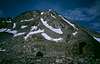
Mt. Solomons is a short, easy climb from Muir Pass on the John Muir Trail/Pacific Crest Trail (“JMT/PCT”). For JMT/PCT hikers, Mt. Solomons provides an easy opportunity to climb a nearby thirteener. Mount Solomons has excellent views of much of the High Sierra, including views of Mt. Ritter, Banner Peak, Mt. Goddard, Charybdis, Black Giant, Mt. Darwin, Mt. Whitney, the Palisades, the Kaweah Range and the Great Western Divide. To the east and over the Sierra Crest is White Mountain.
M.H. Pramme and F.F. Harms first climbed Mt. Solomons from Muir Pass in 1929. Now Mt. Solomons is climbed somewhat frequently.
Setting and Geology
Mt. Solomons is located 0.5 mile south of the JMT/PCT at the junction of LeConte Canyon, Ionian Basin, and Evolution Basin in a high, barren alpine area. Mt. Solomons is a granitic peak in an area that is dominated by dark metamorphic rock. However, the rock is not better for climbing because most routes involve climbing over a lot of talus.
Muir Hut
One of the most notable landmarks along the John Muir Trail is the Muir Hut, located on top of 11,955-ft. high Muir Pass. The Muir Hut was built in 1931 by the Sierra Club and named to honor its founding president and early Sierra explorer and conservationist. It was built for use as an emergency shelter for hikers. Although overnight stays are not allowed in the hut, stopping by and touring the hut is a highlight of a visit to the area.
 |  |  |  |  |
Established Routes:
No technical routes exist. The hardest route is rated class 3.
From Muir Pass:
Most people climb Mt. Solomons from Muir Pass. Many possible class 2 routes are available. Simply pick an appealing rib and follow it up. One class 2 route has some interesting rock to climb over and is shown below. That route climbs a rib that is to the left of a snowfield. When you reach the top of the rib, proceed up boulders to the summit. The rib is a nice break from talus. Easy snow climbs are possible on the snowfields between the ribs. Most routes will require 2-3 hours round trip to complete.
Other Routes include:
* Two class 2 routes, the West Ridge and South Ridge, from Ionian Basin.
* One class 3 route, the East Ridge.
See R.J. Secor, The High Sierra: Peaks, Passes, and Trails, or Steve Roper, The Climber’s Guide to the High Sierra (out of print), for additional information on routes.
 |
Theodore Solomons
Mt. Solomons was named after Theodore Solomons, who was among the first persons to envision a trail running along the Sierra Crest from Yosemite to Mt. Whitney. In 1896, he explored and described much of the San Joaquin River drainage, including the upper portion of Evolution Creek, hoping to find an easy route across the San Joaquin-Kings Divide that is “Practicable for pack animals.” He named many of the region’s most prominent peaks, including Mts. Darwin, Huxley, Haeckel, Wallace, Spencer and Fiske
See James G. Moore, Exploring the Highest Sierra.
Getting There
Several approaches to Muir Pass are possible:
Florence Lake
Either hike 5.2 miles around Florence Lake or take a ferry across the lake. Proceed up the Florence Lake Trail for another 6.2 miles until reaching the John Muir Trail (“JMT”). Continue up the JMT for 5.6 miles, reaching a trail junction. Then, hike 13 miles up Evolution Valley along the JMT to Muir Pass (11,955 ft.).
North Lake
From North Lake, hike 5.0 miles up to Piute Pass (11,423 ft.). Hike down from the pass following the Piute Canyon Trail for 12.4 miles until reaching the JMT. This is a beautiful trail. Continue up the JMT for 3.8 miles, reaching a trail junction. Then, hike 13 miles up Evolution Valley along the JMT to Muir Pass.
South Lake
From South Lake, hike 6.0 miles up Bishop Pass (11,972 ft.). This is a popular trailhead for approaching the Palisades. Hike down 6.6 miles to LeConte Canyon. Hike north up the JMT for 7.0 miles until reaching Muir Pass.
Other variations include crossing a few eastside cross-country passes such as Lamarck Col from North Lake or Echo Col from Sabrina Lake, which as Steeleman notes, is a lower and more direct eastside route than Lamarck Col (although more difficult, too). Another option is to traverse Ionian Basin from Martha Lake.
Red Tape
A wilderness permit is required for overnight stays in the John Muir Wilderness in Inyo or Sierra National Forests or Kings Canyon National Park. You only need to obtain a wilderness permit for your entry point. For example, if you enter in Sierra National forest, you do not need to obtain an additional permit for Kings Canyon National Park. Thus, only one permit is needed per trip.
Although it is located in Kings Canyon National Park, most people enter through Sierra or Inyo National Forests. For entry through Inyo National Forest, wilderness permits may be obtained at the White Mountain Ranger Station, located in Bishop, California. Permits can also be reserved in advance, which is recommended since many trailheads are subject to use quotas. Permits may be reserved for a fee of $5/person. Information on Inyo National Forest permit reservations is available online or call (760) 876-6200.
For entry through Sierra National Forest, wilderness permits may be obtained at the High Sierra Ranger Station, located in Prather, California. Permits can also be reserved in advance, which is recommended since many trailheads are subject to use quotas. Permits may be reserved for a fee of $5/person. Information on Sierra National Forest permit reservations is available online or call (559) 297-0706.
When To Climb
June-October. Winter climbs are possible but difficult because of the remote location.
Camping
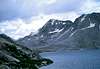
Wanda Lake, Lake McDermond and Helen Lake provide easy access to Mt. Solomons. To the south, Ionian Basin has several small lakes that are suitable for camping.
 |
Mountain Conditions
Kings Canyon National Park: (559) 565-3341
Inyo National Forest visitor information: (760) 876-6200
Sierra National Forest visitor information: (559) 855-5355
Updated weather information is also available.