
|
|
Mountain/Rock |
|---|---|
|
|
35.05240°N / 83.4775°W |
|
|
5280 ft / 1609 m |
|
|
Overview

AT to summit.
Albert Mountain is an outstanding and historically significant peak in the Standing Indian Basin section along the Appalachian Trail. Its summit is very rocky and involves quite a steep ascent from either north or south with some light scrambling if coming up from Mooney Gap. On the summit is a very fine fire lookout that was built in the early 50s to replace an older, wooden structure on Standing Indian Mountain. This fire tower is in excellent repair and was, in fact, a live-in tower with rangers manning it for extended periods.
 AT from Mooney Gap.
I'm not sure if the live-in section is ever open to the public. On my hike to the summit, it was locked, but the views from the catwalk must be exceptional. There are decent views available from the stair section, and from the cliff face upon which the tower is bolted.
Thunderstorms are notoriously dangerous along this section of the AT, and a bypass route is available for hikers if bad weather strikes and one does not wish to risk hiking on this prominent summit during a lightning event. Merely follow FS Road 67 to the bypass trail which will take one around the summit. Or take the bypass trail to the road and down to Bearpen Gap if headed in the other direction.
Albert Mountain sits just north of the Southern Nantahala Wilderness, with its eastern slopes plunging down into the gorge that is largely regulated by the Coweeta Hyrdological Laboratory. Wonderful views into this experimental area and south into the wilderness are evident from the cliffs at the top.
 |
 |
Getting There
From NC 64 take the Wallace Gap Road toward Standing Indian Campground. Pass the Campground entrance on FS Road 67 and continue past the Backcountry Information Center (a set of three large bulletin boards) where the road goes from hardtop to gravel. Drive on past Hurrican horse/camp area to the intersection with FS Road 83. Either take the lefthand turn where there's a sign indicating "Albert Mountain" and park as the intersection of the AT and Bearpen Gap Trail. Take the AT up to Albert for a very short hike of about half a mile with a very steep gain of about 400 feet to the summit.
Another option for a longer hike is to take FS Road 83 to Mooney Gap and follow the AT north to the summit of Albert Mountain. A hike of about 2.5 miles.
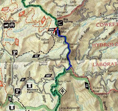 Map.
Map.Red Tape
No red tape, at all. Albert Mountain is in the Nantahala National Forest along the Appalachian Trail. No fees. No restrictions beyond those of the National Forest Service and common sense.
 |
 |
When To Climb
Albert Mountain can be climbed all year. Be aware of the frequency and severity of the thunderstorms that hit this part of the southern Appalachians. There is a bypass route along FS Road 67 and Trail 36A if the weather is severe.
 |
 |
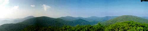 View
ViewCamping
Camping is available nearby at Standing Indian Campground ($14 per night), at the semi-developed Hurricane site ($6 per night), or for free at various sites inside the Nantahala National Forest. The nearest AT shelters are just north at Big Spring and about six miles south at Carter Gap.
Mountain Conditions
Check the weather for Franklin, NC. Subtract about ten degrees for the highest peaks.
 |
External Links
- Albert Mountain Fire Tower.
Nice link to a website with information about Albert Mountain. - Coweeta Hydrologic Laboratory.
Link to the Coweeta Hydrologic Laboratory, co-run by the University of Georgia. An excellent and fascinating site.